Atlantic

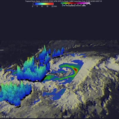
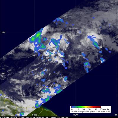
Ida Weakened by Strong Shear in the Atlantic

Tropical Depression Ida has struggled to maintain itself in the Central Atlantic well east of the Leeward Islands where it has been ravaged by strong wind shear. Since forming back on the 18th of September, Ida has not been able to strengthen beyond a moderate tropical storm, reaching a peak intensity of 45 knots (50 mph) early on the morning of the 21st before succumbing to the effects of strong northwesterly winds from an upper-level trough. Since that time, Ida has struggled maintain itself between a depression and a weak tropical storm, while being mired in the Central Atlantic. This most

Tropical Storm Danny Forms in the Atlantic

Tropical Storm Danny became the 4th named storm of the season yesterday afternoon when it formed in the central Atlantic about 1660 miles east of the Windward Islands. Danny originated from an African easterly wave that moved off of the coast of Africa 4 days earlier on the 14th of August. Storms that form in this region are known as Cape Verde storms and typically form towards the height of hurricane season. In a typical season, there are about 10 named storms and 6 hurricanes. With this year being a potentially strong El Nino year, Atlantic hurricanes are usually suppressed. However, it only
GPM Flies Over Hurricane Gonzalo
Download in Hi-Res from the Scientific Visualization Studio On October 16th, 2014 (1342 UTC) the Global Precipitation Measurement (GPM) mission's Core Observatory flew over Hurricane Gonzalo as it headed towards Bermuda. Hurricane Gonzalo remains a category 4 hurricane on the Saffir-Simpson Hurricane Scale, with maximum sustained winds at 130 mph. As of 12:00 UTC (8:00a.m. EDT) on Friday, October 17th, the National Hurricane Center forecast located the storm about 195 miles south southwest of Bermuda, where a hurricane warning is in effect. The GPM Core Observatory carries two instruments that...

Atlantic Tropical Storm Bertha Forms

The National Hurricane Center (NHC) upgraded a well defined low pressure center east-southeast of Barbados to tropical storm Bertha on July 31, 2014 at 0300 UTC (11 PM AST). Bertha's development is inhibited by vertical wind shear that may weaken as the tropical storm moves over the northeastern Caribbean Sea. The TRMM satellite had an excellent view of tropical storm Bertha on August 1, 2014 at 0713 UTC (3:13 AM AST). Rainfall from TRMM's Microwave Imager (TMI) and Precipitation Radar (PR) with this TRMM pass is shown overlaid on a GOES-EAST enhanced infrared image received at 0715 UTC. Those
GPM Satellite Sees First Atlantic Hurricane
Animation of NASA-JAXA's GPM satellite data of rain rates and internal structure of Hurricane Arthur on July 3 2014. Image Credit: NASA's Scientific Visualization Studio / JAXA Download the Hi-Res Video Here The Global Precipitation Measurement (GPM) Core Observatory flew over Hurricane Arthur five times between July 1 and July 5, 2014. Arthur is the first tropical cyclone of the 2014 Atlantic hurricane season. GPM is a joint mission between NASA and the Japan Aerospace Exploration Agency. The Core Observatory was launched Feb. 27 from Japan and began its prime mission on May 29, just in time...

GPM Dissects Hurricane Arthur

Submitted by JacobAdmin on Tue, 07/08/2014
Video Embed

The Global Precipitation Measurement mission's Core Observatory flew over Hurricane Arthur five times between July 1 and July 6, 2014. Arthur is the first tropical cyclone of the 2014 Atlantic Hurricane season. It formed as a tropical storm on Tuesday, July 1 and reached maximum intensity as a Category 2 hurricane on July 4, disrupting some coastal U.S. Independence Day celebrations. This visualization is taken from the flyover on July 3, 2014 with Hurricane Arthur just off the South Carolina coast.

TRMM Sees Arthur Intensifying

Tropical storm Arthur intensified and was upgraded to a hurricane by the National Hurricane Center (NHC) early this morning. The TRMM satellite flew above the intensifying tropical storm on July 2, 2014 at 2156 UTC (7:56 PM EDT). At that time TRMM found that Arthur hadn't formed an eye but had heavy rain near the center of a well defined circulation. Rainfall derived from TRMM's Microwave Imager (TMI) and Precipitation Radar (PR) is shown overlaid on a GOES-EAST Visible/Infrared image collected at the same time as the TRMM pass.

TRMM Looks At Potential Atlantic Storm

On 1 August 2011 at 0056 UTC the TRMM satellite traveled above an area of low pressure east of the Lesser Antilles that the National Hurricane Center (NHC) has assigned a high probability (90%) of becoming an Atlantic tropical cyclone within the next few days. TRMM's Precipitation Radar (PR) saw a few tall convective thunderstorm towers within this area (see below image).