Atlantic

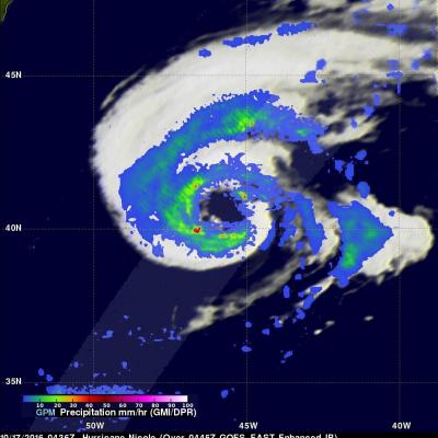
GPM Sees Hurricane Florence Swirling In The Central Atlantic

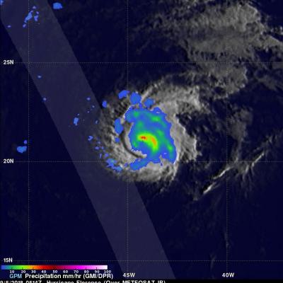
Hurricane FLORENCE became more powerful over the past few days while moving through the central Atlantic Ocean. Wind speeds increased from tropical storm force to hurricane force on Tuesday. FLORENCE's maximum sustained winds were about 85 kts (98 mph) early today making it a category two hurricane on the Saffir-Simpson Hurricane wind scale. Hurricane FLORENCE is being steered toward the northwest by the Atlantic subtropical ridge. Early next week the National Hurricane Center (NHC) predicts that hurricane FLORENCE will have moved to a location southeast of Bermuda. The GPM core observatory

Forming Tropical Storm Don's Rain Checked By GPM

On Monday July 17, 2017 at 5:00 PM EDT a tropical disturbance in the Atlantic Ocean was upgraded to tropical storm Don, the fourth Atlantic Tropical storm of 2017. The GPM core observatory satellite flew above the forming tropical storm much earlier in the same day at 3:17 AM EDT (0717 UTC). GPM's Microwave Imager (GMI) and Dual-Frequency Precipitation Radar (DPR) instruments collected data that were used to evaluate precipitation within the forming tropical cyclone. GPM's Radar data swath (shown in lighter shades) covered an area to the west of the greatest amount of rainfall. GPM's radar

Arlene Becomes Rare Atlantic Tropical Cyclone

Tropical storms are quite rare in the Atlantic at this time of the year, which is why the formation of Tropical Storm Arlene in the north Central Atlantic yesterday, Thursday April 20th at 5:00 pm EDT, was so unusual. The National Hurricane Center (NHC) noted that Arlene became only the 2nd tropical storm to form in the Atlantic during the month of April in the entire satellite era, the other being Tropical Storm Ana back in 2003. GPM captured this timely image of Arlene just after the NHC officially designated it to be a tropical storm. The image was taken at 21:56 UTC (5:56 pm EDT) on

GPM Sees the Formation of Early Atlantic Ocean Tropical Depression 1

A low pressure area in the Atlantic Ocean, located southwest of the Azores was designated as Subtropical Depression One on April 19 as NASA examined its rainfall. By April 20 it had become the Atlantic's first tropical depression. Just as the subtropical depression was forming in the North Atlantic Ocean on April 19 at 11 a.m. EDT (1500 UTC) the Global Precipitation Measurement Mission or GPM core observatory satellite flew directly over it and identified areas where rainfall was heaviest in the system. Data collected by GPM's Microwave Imager (GMI) and Dual-Frequency Precipitation Radar (DPR)

Hurricane Nicole Moving Over Cold North Atlantic

Hurricane Nicole has now been active for almost two weeks. Nicole was still a hurricane with winds of about 70 kts (81 mph) when the GPM core observatory satellite flew over on October 17, 2016 at 0436 UTC (2:36 am EDT). The GPM satellite had a good look at the rainfall in Nicole's large ragged eye. GPM's Dual-Frequency Precipitation Radar (DPR) swath sliced through the center of Nicole's eye and found some very heavy rainfall. A few strong storms in the southern side of the eye were dropping rain at a rate of over 113 mm (4.4 inches) per hour. GPM's radar (DPR KU band) data collected with

Gaston Hovers Around Hurricane Intensity as it Moves into the Central Atlantic

Gaston became the 3rd hurricane of the season early this morning (just after midnight EDT) as the storm was moving northwestward into the Central Atlantic about midway between the Leeward Islands and the Cape Verde Islands before weakening back into a tropical storm less than 12 hours later. Gaston is continuing to battle relatively strong environmental wind shear brought about by an upper-level low pressure center positioned to the west of Gaston. Winds flowing counter-clockwise around the upper low are blowing from the southwest while Gaston is moving northwest. These opposing winds are

GPM Satellite Sees Forming Atlantic Tropical Depression

Tropical Depression Six (TD06L) formed in the Eastern Atlantic Ocean southwest of the Cape Verde Islands late Tuesday evening. TD06L has become better organized today. The National Hurricane Center (NHC) predicts that the tropical depression will intensify and become tropical storm Fiona later today. The tropical storm is predicted to become slightly more powerful while moving toward the northwest over the open waters of the central Atlantic. The GPM core observatory satellite collected data when TD06L was forming on August 16, 2016 at 2031 UTC. GPM data showed that the forming tropical

GPM Sees Tropical Depression Bonnie In The Atlantic

The GPM core Observatory had another good look at revived tropical Depression Bonnie on June 3, 2016 at 0716 UTC (3:16 AM EDT). Rainfall calculated from data received by GPM's Microwave Imager (GMI) and and Dual-Frequency Precipitation Radar (DPR) instruments are shown in the first image. Those instruments found that Bonnie was dropping rain at a rate of over 65 mm (2.6 inches) per hour in storms south of the depression's center of circulation. GPM's Radar (DPR Ku Band) again measured the 3-D structure of rainfall within Bonnie and found that some storms were reaching heights of over 13 km (8

GPM Sees Potential Atlantic Tropical Cyclone

An area of low pressure located in the Atlantic Ocean between Bermuda and the Bahamas is being monitored today for possible development into a tropical or subtropical cyclone. Shower activity has increased in the area. The National Hurricane Center (NHC) has advised interests along the southeastern coast of the United States to monitor the progress of this low. The GPM core observatory satellite flew over this showery area on May 26, 2016 at 0932 UTC (5:30 AM EDT). GPM's Microwave Imager (GMI) and and Dual-Frequency Precipitation Radar (DPR) instruments measured precipitation around the low

Alex Becomes the Earliest Hurricane to Form in the Atlantic Since 1938

Alex is a rare storm indeed. Alex officially became a hurricane yesterday at 11:00 am Atlantic Standard Time (AST) with maximum sustained winds estimated at 85 mph by the National Hurricane Center (NHC), making it the earliest hurricane to form in the Atlantic since 1938, when the first storm of the season became a hurricane on the 4th of January. As with Alex, that storm too originated from an extratropical low pressure center. The last hurricane to occur in January was Hurricane Alice in 1955, but Alice had already become a hurricane in the year before at the end of December and survived