Bahamas

GPM Overpass of Hurricane Dorian
Tropical cyclones, known as hurricanes in the western hemisphere, can bring damaging high winds, storm surge, and flooding rainfall to the coastal communities they hit. Satellite instruments - and the detailed near real-time atmospheric data that they provide - have revolutionized the way we see hurricanes and other disasters as they happen. But it’s about more than just seeing. NASA, working with counterparts at NOAA, FEMA, and elsewhere are sharing ever more precise data to aid local communities in coping with disasters. With better information, emergency responders have the tools to make...
Hurricane Dorian Brings Heavy Rain to Bahamas
In addition to the powerful winds that have raked the northern Bahamas over the past few days, Hurricane Dorian’s slow motion has brought very heavy rainfall to the islands as well. Dorian first formed into a tropical depression on the 24th of August about 800 miles east southeast of Barbados in the Lesser Antilles from an area of low pressure; the depression was quickly upgraded to a minimal tropical storm and named Dorian by the National Hurricane Center (NHC) later in the day. As Dorian made its way westward under the influence of a high pressure ridge to the north, it was held in check...
GPM Observes Hurricane Dorian Over Bahamas
Download in high resolution from the NASA Goddard Scientific Visualization Studio. The NASA / JAXA Global Precipitation Measurement (GPM) Core Observatory flew over Hurricane Dorian on September 1st (5:22pm ET / 21:22 UTC) as the storm was directly over Abaco Island in The Bahamas. The satellite captured data on rainfall rates within the storm as it flew over using its Dual-frequency Precipitation Radar (DPR) and GPM Microwave Imager (GMI). In this animation the multi-satellite GPM IMERG product is shown first to illustrate rainfall rates prior to the overpass. When the camera zooms in data...

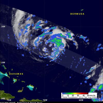
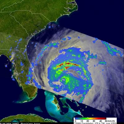
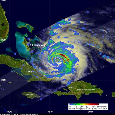
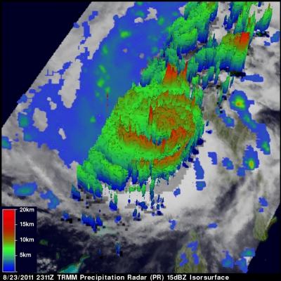
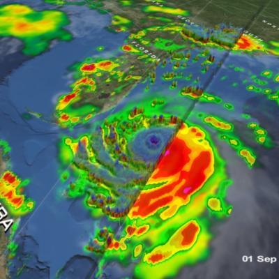
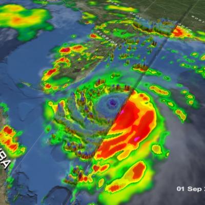
Matthew Brings Heavy Rains, Destruction to Parts of the Northern Caribbean

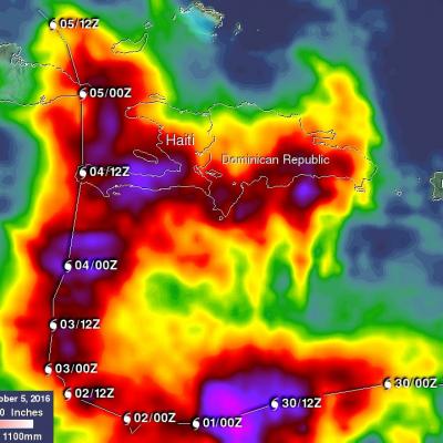
Matthew began as a fairly impressive tropical wave that emerged off of the coast of Africa on the 23rd of September but had to make its way all the way across the Central Atlantic before finally organizing into a tropical storm on the morning of the 28th while passing through the Windward Islands. Matthew then slowly but steadily intensified into a minimal hurricane by the early afternoon of the following day as it continued to track westward through the central eastern Caribbean. The next day, September 30th, Matthew underwent a period of rapid intensification; its winds increased in

TRMM Sees Subtropical Storm Sean

The National Hurricane Center (NHC) upgraded a low pressure center in the Atlantic Ocean to subtropical storm Sean at 0900 UTC ( 4:00 AM EDT). The TRMM satellite flew directly above Sean a little earlier on 8 November 2011 at 0731 UTC ( 2:31 AM EDT) collecting data used in the precipitation analyses shown. TRMM Precipitation Radar (PR) data in the 3-D display above show that scattered moderate storms within Sean were reaching maximum heights of only about 11km (~6.8 miles). The "top down" view on the right above shows that Sean was well organized but most rainfall was of low to moderate

Hurricane Irene Passes Through Bahamas and Heads Toward Cape Hatteras

Hurricane Irene was seen affecting the Bahamas twice during the daytime by the TRMM satellite on Thursday 25 August 2011 at 1624 UTC ( 12:24 PM EDT) and at 2118 UTC ( 5:17 PM EDT). A rainfall analysis from TRMM's Microwave Imager (TMI) data shows that Irene's eye had moved to the north of the islands of the Bahamas by the second pass. TRMM' Precipitation Radar (PR) data shows that at this time Irene contained bands of intense thunderstorms dropping rain at the rate of over 50 mm/hr (~2 inches) north of the hurricane's eye. Irene weakened slightly today (Friday) from a category 3 to a strong
TRMM image of hurricane Irene intesifying as it nears the Bahamas
UPDATE: Monday, August 29th, 2011 Irene Drenches Northeastern United States UPDATE: Friday, August 26th, 2011 Irene Passes Through the Bahamas, Heads Towards Cape Hatterus Wednesday, August 24th, 2011 After becoming a small hurricane while passing over Puerto Rico, Irene re-emerged over the warm, open waters of the western Atlantic northwest of the Dominican Republic on the morning of August 22nd. The storm quickly showed signs of intensifying as deep convective towers arose near the center of Irene, releasing heat into the core of the system. In response, Irene's central pressure fell and...

Irene Gathers Strength, Takes Aim at the Bahamas

After becoming a small hurricane while passing over Puerto Rico, Irene re-emerged over the warm, open waters of the western Atlantic northwest of the Dominican Republic on the morning of August 22nd. The storm quickly showed signs of intensifying as deep convective towers arose near the center of Irene, releasing heat into the core of the system. In response, Irene's central pressure fell and winds intensified, making it a Category 2 storm on the Saffir-Simpson hurricane intensity scale with sustained winds reported at 85 knots (~100 mph) by the National Hurricane Center by the end of the day