flooding

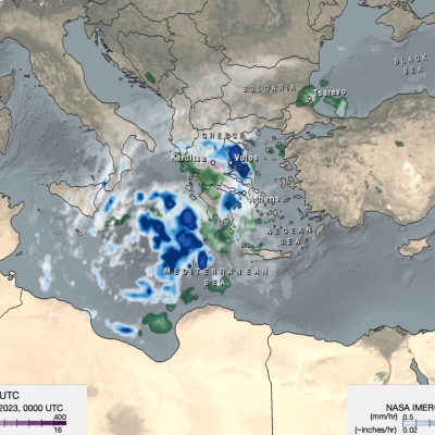
Map of IMERG precipitation estimates from recent flooding rainfall in Greece.
On Sept. 4, 2023, a low-pressure system developed over southeastern Europe that would lead to devastating floods over Greece and other parts of the region. The system was given the name “Daniel” by local meteorological agencies. Daniel was dynamically driven by strong cyclonic flow in the upper-level winds over southeastern Europe. The upper-levels winds combined with low-level winds from the northeast which supplied moisture from the unusually warm waters of the Aegean and Black Seas to central Greece. According to satellite infrared and microwave estimates from NASA's MUR and NOAA’s OISST v2

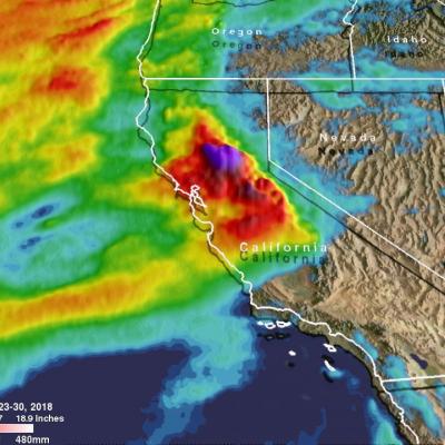
IMERG Measures Flooding Rainfall In Deadly California Wildfire Areas

Heavy precipitation has been falling in areas of California that were recently devastated by deadly wildfires. This flooding rainfall has resulted in evacuations in burn scarred areas such as Butte County where the deadly Camp Fire hit this month. Flash floods, debris flows and mudslides are now predicted in areas where deadly wildfires stripped away vegetation. On a positive note these Pacific storms are expected to dampen wildfires and replenish the Sierra Nevada snowpack. This snowpack is an important source of water for California's streams and rivers. NASA's Integrated Multi-satellitE

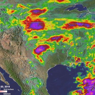
Heavy Rainfall Across the U.S. Measured from Space

For close to two weeks the combination of a nearly stationary front and tropical moisture caused almost continuous precipitation over much of the Mid-Atlantic. Record amounts of rain fell over the eastern United States with over a foot of rain reported in some parts of the Mid-Atlantic. The excessive rain led to flooding along several rivers including the Potomac river. This image shows anomalous rainfall for the period from May 11-20, 2018. This analysis used climatology data that were based on measurements by the Tropical Rainfall Measuring Mission (TRMM) satellite from 1997- 2015. The TRMM

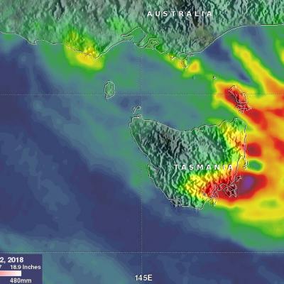
Tasmania's Flooding Rainfall Measured With NASA's IMERG

Last week Tasmanian's were evacuated, businesses were flooded and cars washed away as extreme rainfall accompanied a strong cold front and a low pressure system that spawned violent storms. Hobart city, located in southeastern Tasmania, received record breaking rainfall of more than 100 mm (3.93 inches) in a single day. A strong pressure gradient developed between the complex low pressure center over Tasmania and high pressure that was moving eastward over the Great Australian Bight (Southern Ocean). This strong pressure gradient resulted in destructively high south-easterly winds over

Severe Midwest Storms Probed By GPM Satellite

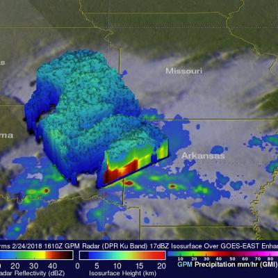
The GPM core observatory satellite flew over stormy weather in the Midwest on Saturday February 24, 2018 at 1610 UTC (10:10 AM CST). Floods and very severe thunderstorms were developing with this slow moving storm complex. Later in the day tornadoes within these storms caused destruction and injuries in the states of Kentucky, Arkansas, Missouri and Tennessee. Tornadoes and flooding were blamed for at least four fatalities. Kentucky was particularly hard hit with Saturday evening tornadoes moving through southwestern Kentucky causing multiple injuries and at least three deaths. GPM's microwave
GPM Examines Hurricane Irma
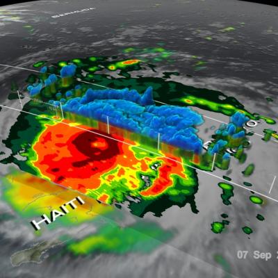
The GPM core observatory satellite had an exceptional view of hurricane Irma's eye when it flew above it on September 5, 2017 at 12:52 PM AST (1652 UTC). This visualization shows a rainfall analysis that was derived from GPM's Microwave Imager (GMI) and Dual-Frequency Precipitation Radar (DPR) data. Irma was approaching the Leeward Islands with maximum sustained winds of about 178 mph (155 kts). This made Irma a dangerous category five hurricane on the Saffir-Simpson hurricane wind scale. Intense rainfall is shown within Irma's nearly circular eye. This 3-D cross-section through Irma's eye was...

Irma’s Heavy Rainfall Measured With GPM IMERG

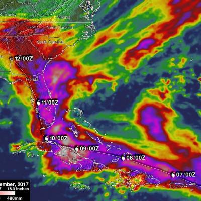
Hurricane Irma dropped extremely heavy rain at times during it’s trek from near the Cape Verdi Islands through the northern Leeward islands, Cuba and the southeastern United States. Over 16 inches (406 mm) of rain was reported in Guantanamo, in the easternmost province of Cuba, as the category five hurricane battered the country. Almost 16 inches (406 mm) of rain was also reported at Fort Pierce on the eastern side of Florida. Charleston, South Carolina reported 6 inches (152.4 mm) of rain in 24 hour. This heavy rainfall plus storm surge flooding caused the worst flooding in Charleston since
GPM Captures Hurricane Harvey's Rainfall
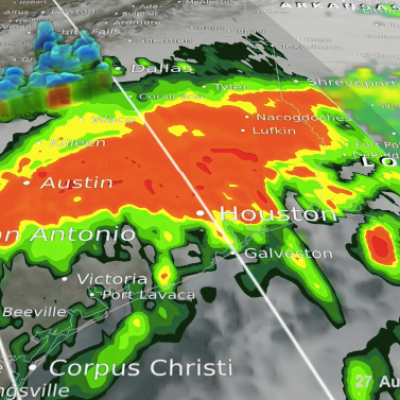
Music: "Whirlpool," Michael Jan Levine, Killer Tracks The Global Precipitation Measurement (GPM) Core Observatory captured these images of Hurricane Harvey at 11:45 UTC and 21:25 UTC on the 27th of August nearly two days after the storm made landfall as it was meandering slowly southeast at just 2 mph (~4 kph) near Victoria, Texas west of Houston. The image shows rain rates derived from GPM's GMI microwave imager (outer swath) and dual-frequency precipitation radar or DPR (inner swath) overlaid on enhanced visible/infrared data from the GOES-East satellite. Harvey's cyclonic circulation is...

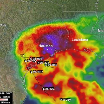
NASA's IMERG Shows Rainfall Accumulation Along Harvey's Track

Total rainfall estimates from NASA's Integrated Multi-satelliE Retrievals for GPM (IMERG) data are shown here for the period from August 23-29, 2017. During this period hurricane Harvey dropped heavy rainfall as it moved through the Gulf Of Mexico and stalled over Texas. It has been reported that Harvey dropped over 40 inches (1016 mm) of rain over southeastern Texas during this period. Hurricane Harvey's locations and track are shown here overlaid in white IMERG Data are produced using data from the satellites in the GPM Constellation, and is calibrated with measurements from the GPM Core