Mexico

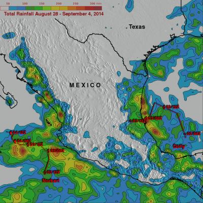
Hurricane Odile Rainfall Totals

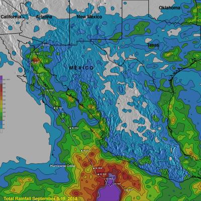
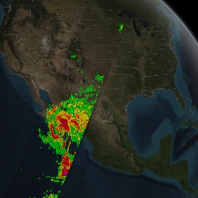
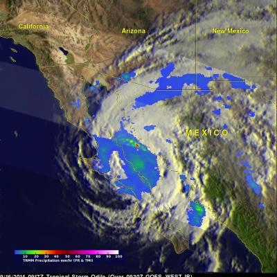
During the past week hurricane Odile and remnants have produced heavy rainfall that caused dangerous flooding over the Baja California peninsula and the southwestern United States. Rainfall from Odile may be welcomed in the Southwest where some areas have been experiencing extreme to exceptional drought conditions. The Tropical Rainfall Measuring Mission or TRMM satellite was launched in November 1997 with the primary mission of measuring rainfall in the Tropics using a combination of passive microwave and active radar sensors. The rainfall analysis above was made using real-time TRMM Multi
GPM Captures Hurricane Odile
​ ​ Animation revealing a swath of GPM/GMI precipitation rates over Hurricane Odile. The camera then moves down closer to the Hurricane to reveal DPR's volumetric view of Odile. As the camera rotates around the Hurricane, a slicing plane dissects Odile revealing it's inner precipitation rates closer to the eye. Shades of blue indicate frozen precipitation (in the upper atmosphere). Shades of green to red are liquid precipitation which extend down to the ground. On September 15, 2014 (15:11 UTC) the Global Precipitation Measurement (GPM) mission's Core Observatory flew over Hurricane Odile as...

Baja California Battered And Drenched By Odile

Category three hurricane Odile caused widespread destruction after hitting Baja California on Sunday night. Odile had weakened to a tropical storm with winds of about 55 kts ( 63.3 mph) when the TRMM satellite flew over on September 16, 2014 at 0917 UTC (2:19 AM PDT). Odile was still well organized and TRMM's Precipitation Radar (PR) measured rain falling at a rate of almost 130 mm (5.1 inches) per hour northeast of the tropical storms's center of circulation. The tops of some strong thunderstorms over the Gulf Of California were reaching heights of 13km (8 miles) and returning radar

Norbert & Dolly Rain On Both Mexican Coasts

Tropical storm Dolly dissipated quickly after coming ashore yesterday in eastern Mexico but dropped heavy rain in some areas near the Gulf coast. At the same time tropical storm Norbert was approaching from the west and contributing to rainfall near Mexico's Pacific coast. TRMM-based, near-real time Multi-satellite Precipitation Analysis (MPA) data for the period from August 28 to September 4, 2014 were used in the analysis shown above. The approximate past locations of the tropical cyclones at 0000Z and 1200Z are shown overlaid in red on this analysis. The heaviest rainfall totals were found

Tropical Storm Dolly Hits Eastern Mexico

Tropical storm Dolly is dissipating after coming ashore in eastern Mexico late yesterday evening. The TRMM satellite flew over tropical storm Dolly early on September 3, 2014 at 0844 UTC ( 3:33 AM CTD) providing data used in the image above. TRMM's Microwave Imager (TMI) collected with that orbit showed that Dolly was dropping light to moderate rainfall near the dissipating storm's center of circulation. Moderate to heavy rainfall, falling at a rate of over 30 mm ( about 1.2 inches) per hour, was shown in a strong band of showers moving ashore north of Dolly's center. The TRMM satellite had a

Cristina Now A Hurricane

Tropical storm Cristina intensified and was a category one hurricane with wind speeds of over 65 kts (about 75 mph) when the TRMM satellite flew over on June 11, 2014 at 1142 UTC (4:42 AM PDT). A rainfall analysis that used data from TRMM's Microwave Imager (TMI) and Precipitation Radar (PR) instruments is shown overlaid on an enhanced infrared image received by the GOES-EAST satellite at 1145 UTC. TRMM TMI data clearly revealed that an eye had developed indicating that Cristina was definitely a hurricane. TRMM PR found that rain was falling at a rate of over 74.4 mm/hr (about 2.9 inches) in a

Heavy Rainfall For Mexico & Central America

The movement of tropical storm Boris into southern Mexico and a nearly stationary low pressure system in the southern Gulf Of Mexico has been causing heavy rainfall in that area. The TRMM-based, near-real time Multi-satellite Precipitation Analysis (TMPA) at the NASA Goddard Space Flight Center monitors rainfall over the global Tropics. TMPA rainfall totals are shown here for the period May 29 to June 6, 2014. The highest rainfall totals of over 535 mm were analyzed where tropical storm Boris came ashore in southern Mexico. The slow moving low pressure center in the Bay Of Campeche is

Boris Intensifies, Hits Mexico And Dissipates

Tropical Depression TWO-E was upgraded to tropical storm Boris yesterday at 1800 UTC (11AM PDT) but Boris weakened to a tropical depression after going ashore in Mexico. The TRMM satellite passed above tropical depression Boris on June 4, 2014 at 1457 UTC and collected data used in this rainfall analysis. TRMM rainfall data are shown overlaid on a GOES-EAST enhanced infrared/visible image received at 1445 UTC. TRMM's Microwave Imager (TMI) data show that Boris was still dropping light to moderate rain over southern Mexico in the area of the Gulf Of Tehuantepec. Click on this animation to see a

Hurricane Raymond Soaking Mexican Coast

A month ago hurricane Manuel caused caused landslides and extensive flooding along Mexico's Pacific Ocean coast. Recently formed hurricane Raymond is expected to cause heavy rainfall in nearly the same area. The TRMM satellite flew directly above hurricane Raymond on October 21, 2013 at 0111 UTC (October 20 at 6:11 PM PDT). TRMM Precipitation Radar (PR) data from that orbit shows that hurricane Raymond contained towering thunderstorms on the western side of the eye wall that were reaching to heights above 15km (~9.3 miles). TRMM PR also recorded precipitation in Raymonds eye wall that was

Mexico Flooded by Tropical Storm Manuel and Hurricane Ingrid

Mexico's Pacific and Gulf coasts were both inundated by deadly tropical rainfall at the same time. Hurricane Manuel dropped extremely heavy rainfall along Mexico's Pacific coast. At least 55 people have been reported killed in Mexico due to flooding and landslides caused by extreme rainfall. Hurricane Ingrid weakened to a tropical storm and came ashore from the Gulf Of Mexico into the state of Tamaulipas near La Pesca, Mexico on Monday September 16,2013. The approximate 0000Z and 1200Z locations of the tropical cyclones are shown overlaid in white. The TRMM-based, near-real time Multi-