Mexico

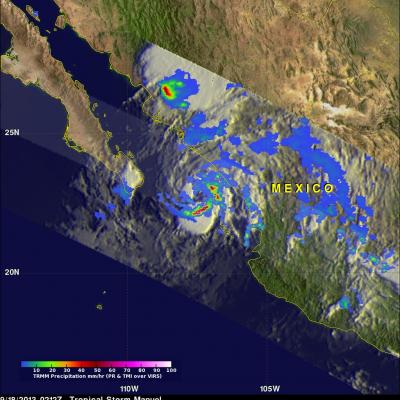
Deadly Manuel Becomes A Hurricane

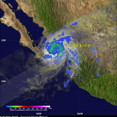
As predicted by the National Hurricane Center (NHC), tropical storm Manuel became a category one hurricane yesterday evening. Manuel, located over the southern Gulf Of California, was an intensifying tropical storm with maximum wind speeds of about 50kts (~57.5 mph) when viewed by the TRMM satellite on September 18, 2013 at 1845 UTC. Manuel had intensified and was a minimal hurricane, hugging Mexico's coast, with wind speeds of about 65kts (~75.8 mph) when seen again by TRMM on September 19, 2013 at 0116 UTC. Rainfall analyses that used TRMM's Microwave Imager (TMI) and Precipitation Radar (PR

Mexico Flooded by Tropical Storm Manuel and Hurricane Ingrid

Mexico's Pacific and Gulf coasts were both inundated by deadly tropical rainfall at the same time. Tropical storm Manuel dropped extremely heavy rainfall along Mexico's Pacific coast. At least 55 people have been reported killed in Mexico due to flooding and landslides caused by extreme rainfall. Hurricane Ingrid weakened to a tropical storm and came ashore from the Gulf Of Mexico into the state of Tamaulipas near La Pesca, Mexico on Monday September 16,2013. The approximate 0000Z and 1200Z locations of the tropical cyclones are shown overlaid in white. The TRMM-based, near-real time Multi-

Heavy Rainfall on Mexico's Pacific and Gulf Coasts

Mexico's Pacific and Gulf coasts are both being inundated by tropical cyclone rainfall at the same time. Tropical storm Manuel has dropped very heavy rainfall along Mexico's Pacific coast. 21 people have been reported killed in this area due to flooding and landslides caused by extreme rainfall. At the same time hurricane Ingrid weakened to a tropical storm and came ashore from the Gulf Of Mexico into the state of Tamaulipas near La Pesca, Mexico . The approximate 0000Z and 1200Z locations of the tropical cyclones are shown overlaid in white. The TRMM-based, near-real time Multi- satellite

Tropical Storm Ingrid Getting Stronger

Tropical storm Ingrid in the southern Gulf Of Mexico was strengthening when the TRMM satellite flew over on September 13, 2013 at 2008 UTC (4:08 PM EDT). A band of very strong convective storms north of Ingrid's center was observed by TRMM's Precipitation Radar (PR) instrument to contain rain falling at the rate of over 143 mm/hr (~5.6 inches). Powerful thunderstorms in this area were also found by TRMM PR to reach heights above 16km (~9.9 miles). These "hot towers" are often a sign that a tropical cyclone will intensify.

Tropical Storm Fernand Causes Deadly Mudslides

Heavy rain with tropical storm Fernand generated mudslides that caused the reported deaths of 13 people in the Mexican state of Veracruz. TRMM precipitation data are used to calibrate rainfall estimates from other satellites. The resulting TRMM- based, near-real time Multi-satellite Precipitation Analysis (TMPA) at the NASA Goddard Space Flight Center is used to estimate rainfall over a wide portion of the globe. The analysis above shows estimated TMPA rainfall totals for the period from August 20-27, 2013 when Fernand was developing and moving through the area. Total Rainfall greater than

Intensifying TD02 Moves Into The Bay Of Campeche

The TRMM satellite passed above tropical depression two on June 18, 2013 at 2336 UTC (6:43 PM CDT). A red circle shows the approximate location of TD02 just before it entered the Bay Of Campeche in the the southern Gulf Of Mexico. Data from TRMM's Microwave Imager (TMI) and Precipitation Radar (PR) instruments showed that TD02 was still only producing light to moderate rainfall. The most intense rainfall over land, at about 28.7mm/hr (~1.1 inches), was found by TRMM's TMI in a line of storms extending from northwestern Guatemala into the Gulf Of Mexico. The National Hurricane Center (NHC)

Hurricane Barbara Comes Ashore in Southern Mexico

Hurricane Barbara recently made landfall along the southern Pacific coast of Mexico. According to the National Hurricane Center (NHC), the center of the storm came ashore around 19:50 UTC (12:50 pm PDT) Wednesday May 29th about 35 km (~20 miles) west of Tonala, Mexico as a minimal Category 1 hurricane with maximum sustained winds of 75 mph. TRMM captured the first image of Barbara several hours after it made landfall. The image was taken at 6:46 pm PDT 29 May (01:46 UTC 30 May) 2013 and shows the horizontal distribution of rain intensity within the storm. Rain rates in the center of the swath

Hurricane Carlotta Moves Toward Mexican Coast

The TRMM satellite flew over hurricane Carlotta again on Friday June 15, 2012 at 1018 UTC. TRMM's Microwave Imager (TMI) showed that Carlotta was much better organized and revealed a developing eye. Heavy rainfall in bands spiraling into the center of Carlotta are shown by TRMM's Precipitation Radar (PR). Past positions and the National Hurricane Center's forecast positions are shown overlaid in white. Carlotta is forecast to become a category two hurricane tomorrow with sustained wind speeds increasing to 85kts (~98 mph) as it nears the Mexican coast.

Hurricane Bud Threatens Western Mexico's Coast

The TRMM satellite passed above hurricane Bud early this morning at 0429 UTC (9:30 PM PDT May 24, 2012). A large area of moderate to heavy rainfall with rates of over 30mm/hr (~1.2 inches) was revealed in Bud by TRMM's Microwave Imager (TMI) instrument. The rainfall analysis was overlaid on an enhanced infrared image derived from TRMM's Visible and InfraRed Scanner (VIRS). Bud's past and predicted locations are shown overlaid in white. Heavy rainfall from hurricane Bud's slow movement may result in severe flooding and dangerous landslides as it moves over Mexico's rugged coastal terrain.

Another Tropical Cyclone Developing

While Tropical storm Aletta is forecast to weaken and dissipate another tropical cyclone appears to be forming in the eastern Pacific south of Acapulco, Mexico. The TRMM satellite passed above this tropical disturbance (92E) on 18 May 2012 at 0957 UTC. Data captured with this pass by TRMM's Microwave Imager (TMI) and Precipitation Radar (PR) instruments were used in the rainfall analysis shown. This analysis indicates that this area contained very heavy rainfall in the northeastern quadrant of the disturbance. Some storms were producing rainfall at a rate of over 50 mm/hr (~2 inches). A 3-D