Mexico

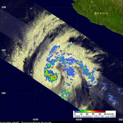
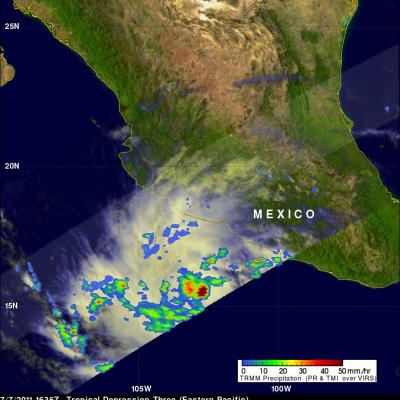
Tropical Storm Aletta Forms JacobAdmin Tue, 05/15/2012
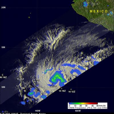
The eastern Pacific hurricane season starts today. Just slightly ahead of schedule tropical storm Aletta formed yesterday well to the southwest of the Mexican coast. The image above uses data captured when the TRMM satellite passed above Aletta on 15 May 2012 at 0253 UTC. TRMM's Microwave Imager (TMI) instrument had a good look at the newly formed storm and showed that Aletta had a large area of light to moderate rainfall north of the storm's center of circulation. The TMI rainfall analysis is shown overlaid on an enhanced infrared image from TRMM's Visible and InfraRed Scanner (VIRS)

Tropical Storm Kenneth

The TRMM satellite had a good view of tropical storm Kenneth in the eastern Pacific Ocean when it passed above on 21 November 2011 at 0510 UTC (20 November 2011 9:10 PM PST). The National Hurricane Center (NHC) upgraded Kenneth to a hurricane on 21 November 2011 at 1500 UTC (7:00 AM PST) after determining that a ragged eye was forming. The image on the right shows a rainfall analysis derived from TRMM's Microwave Imager (TMI) and Precipitation Radar (PR) instruments. TMI data show that heavy rainfall was occurring around the center of Kenneth's circulation.

TRMM Views Area Of Possible Tropical Cyclone Development

The TRMM satellite flew over an area of disturbed weather in the southeastern Gulf Of Mexico on 17 October 2011 at 1310 UTC (9:10 AM EDT). The National Hurricane Center (NHC) has given this area of low pressure a medium chance (40%) of becoming a tropical cyclone during the next 48 hours. A rainfall analysis from TRMM's Microwave Imager (TMI) and Precipitation Radar (PR) data shows that a large area of rainfall associated with this disturbance extends from the northern tip of Mexico's Yucatan Peninsula to the southwest coast of Florida. Several stormy areas within this disturbed weather are

Tropical Systems bring Heavy Rain to Mexico and Central America

Within just the past week, the East Pacific has seen a resurgence in tropical activity with the formation of three tropical systems: two hurricanes and a depression. Two of the systems, the two that would go on to become hurricanes, formed on the evening and night of 5 October 2011. The first was TD #10E, the 10th tropical depression of the season in the East Pacific. It formed about 1000 km (~625 mi) south of the Mexican coast and later strengthened into Hurricane Jova. Jova intensified to a Category 3 hurricane before eventually making landfall as a Category 2 storm on Wednesday October 12th
Hurricane Jova Starting to Affect Mexico JacobAdmin Thu, 10/13/2011
The TRMM satellite passed above hurricane Jova off the west coast of Mexico on 11 October 2011 at 1700 UTC. The image above shows a rainfall analysis from TRMM's Microwave Imager (TMI) and Precipitation Radar (PR) overlaid on a combination visible and infrared image from Visible and InfraRed Scanner (VIRS). This TRMM orbit shows that rainfall bands from the powerful category three hurricane were starting drench coastal Mexico.
Tropical Storm Jova a Possible Threat to Mexico JacobAdmin Fri, 10/07/2011
Two tropical cyclones called Irwin and Jova have developed in the eastern Pacific southwest of Mexico. The TRMM satellite traveled above tropical storm Jova on 7 October 2011 at 0413 UTC collecting data used in the images above. Jova is predicted to become a hurricane on the morning of 8 October and move northeastward toward the Mexican coast. TRMM's Precipitation Radar (PR) data, shown above, reveals that Jova had a cluster of very powerful thunderstorms near the center of the intensifying storm. Some of these thunderstorms were reaching to heights of over 17 km (~10.6 miles).

Tropical Storm Greg Forms

A tropical depression (7E) off the southern coast of Mexico was upgraded by the National Hurricane Center (NHC) to tropical storm Greg shortly after the TRMM satellite saw it on 17 August 2011 at 0534 UTC. TRMM's Microwave Imager (TMI) showed that intense convective thunderstorms within the developing storm were dropping rainfall at rates greater than 30mm/hr (1.2 inches) in an area near the center of the storm. Greg is expected to enhance rainfall over the southwest coastline of mexico for the next day or so. Greg is forecast by the NHC to intensify to hurricane strength within 24 hours while
Intensifying Tropical Storm Eugene JacobAdmin Mon, 08/01/2011
The TRMM satellite showed that tropical storm Eugene was very well organized with heavy thunderstorms located south of a forming eyewall on 1 August 2011 at 1350 UTC. Eugene is expected to move to the northwest and stay off the Mexican coast as have all eastern Pacific tropical cyclones except Beatriz so far this year.
TRMM Views Hurricane Dora JacobAdmin Wed, 07/20/2011
The TRMM satellite had an excellent view of hurricane Dora in the eastern Pacific Ocean southwest of Mexico when it passed over on 20 July 2011 at 1015 UTC. Dora is predicted to become a powerful category 3 hurricane but stay well off the Mexican coast.
Tropical Depression Three Intensifying JacobAdmin Thu, 07/07/2011
Tropical depression Three was showing much better organization with more heavy rainfall when the TRMM satellite saw it again on 7 July 2011 at 1636 UTC. Data from TRMM's Microwave Imager (TMI) showed that heavy rainfall was present in a large area over the center of the intensifying depression and in a feeder band to the west of the center. There were also a few showers shown along the Mexican coast to the northwest of the storm.