tropical cyclones

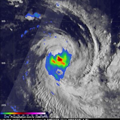
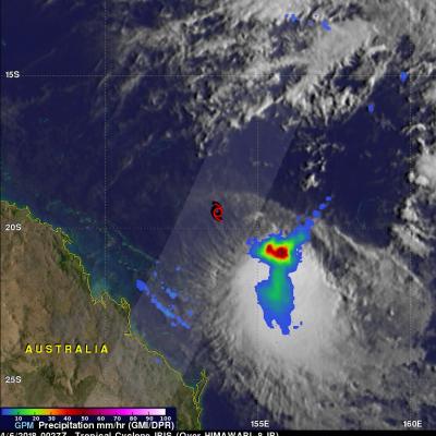
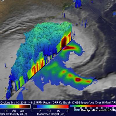
Potential Eastern Pacific Tropical Cyclone Viewed By GPM

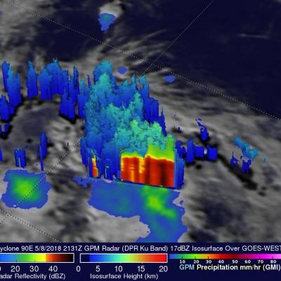
The Eastern Pacific hurricane season officially starts on May 15, 2018. A low pressure center located well to the southwest of the Baja California Peninsula may develop into this area's first tropical cyclone of 2018. Low vertical wind shear and warm ocean temperatures in the vicinity of the low are providing favorable conditions for this low's development into a tropical cyclone. If it develops it will be called Aletta. The GPM core observatory satellite passed over the center of the most intense convective storms in this potential tropical cyclone. Rainfall data collected by GPM's satellite

GPM Satellite Views Tropical Cyclone Flamboyan's Rainfall

Tropical cyclone FLAMBOYAN formed in the middle of the South Indian Ocean well to the west of Australia on April 28, 2018. Today FLAMBOYAN's wind speeds have increased to about 70 kts (81 mph) as the tropical cyclone curved toward the south-southwest around the subtropical ridge. The Joint Typhoon Warning center (JTWC) predicts that FLAMBOYAN will start weakening soon as it moves even farther to the south and encounters increasing vertical wind shear and colder ocean temperatures. The GPM core observatory satellite had a good view of the rainfall in tropical cyclone FLAMBOYAN when it flew over

GPM Sees Tropical Cyclone Fakir Forming Near Madagascar

The southwest Indian Ocean cyclone season started on November 15, 2017 and will officially end on April 30, 2018. A tropical cyclone labeled FAKIR by Meteo France formed today near northeastern Madagascar. FAKIR is expected to intensify as it moves toward the southeast and could be a significant tropical cyclone tomorrow. This cyclone season has already seen Madagascar battered and drenched by tropical cyclones Ava, Dumazile, and Eliakim. The GPM core observatory satellite flew above the forming late season tropical cyclone near northeastern Madagascar on April 22, 2018. The satellite's
Tropical Cyclone Keni Drops Heavy Rain Over Fiji With A Direct Hit To Kadavu JacobAdmin Wed, 04/11/2018
As expected, tropical cyclone KENI followed a track similar to tropical cyclone JOSIE and passed to the southwest of Fiji's main island of Viti Levu on April 10, 2018 (UTC). No casualties were reported with KENI even though it was a more powerful tropical cyclone than JOSIE. KENI was still intensifying when it passed directly over the island of Kadavu located just south of Viti Levu. Flash flooding was reported on Viti Levu and Kadavu. Maximum sustained winds of greater than 70 kts (81 mph) were responsible for widespread damage caused by the direct hit to Kadavu. KENI's peak winds of 85 kts
GPM Sees Keni Following Tropical Cyclone Josie's Track JacobAdmin Mon, 04/09/2018
Another tropical cyclone called KENI has formed in the South Pacific Ocean between Vanuatu and Fiji. The Joint Typhoon Warning Center (JTWC) issued it's first warning for tropical cyclone KENI on April 8, 2018 at 2100Z. Tropical cyclone KENI is following a track similar to tropical cyclone JOSIE that recently caused deadly flooding in Fiji. The GPM core observatory satellite passed above tropical cyclone KENI on April 9, 2018 at 1109Z. This analysis of rainfall around tropical cyclone KENI was accomplished using data collected by GPM Microwave Imager (GMI) and Dual Frequency Precipitation

GPM Shows Rainfall Southeast Of Sheared Tropical Cyclone Iris

The GPM core observatory satellite again passed over the center of tropical cyclone IRIS on April 6, 2018 at 0027 UTC (10:27 AM AEST). The location of IRIS' low level center of circulation is shown here with a red tropical storm symbol. Data collected by GPM's Microwave Imager (GMI) revealed that heavy convective rainfall was sheared to the southeast of IRIS' surface center of circulation. Those GMI data showed that precipitation in that area of strong convection was falling at a rate greater than 59 mm (2.3 inches) per hour while data received by GPM's Dual Frequency Precipitation Radar (DPR)

GPM Satellite Probes Tropical Cyclone Iris Near Australian Coast

IRIS has taken a long, fluctuating and serpentine trek since the tropical cyclone formed in the Coral Sea northeast of Australia on March 24. For a while IRIS weakened and was downgraded to a tropical low. The tropical low moved toward the northeastern coast of Australia and was upgraded again to tropical cyclone IRIS on April 2. The tropical cyclone has then moved generally southeastward parallel to the Australian coast. This analysis from data collected by Microwave Imager (GMI) and Dual Frequency Precipitation Radar (DPR) instruments shows that extremely heavy rain was falling west of IRIS'

Tropical Cyclone Josie's Deadly Flooding Rainfall Examined With IMERG

Tropical cyclone Josie didn't make landfall in Fiji but it's heavy rainfall resulted in deadly flooding. Approximate locations of tropical cyclone Josie, as it moved close to Fiji, are shown overlaid in white. Josie's clockwise circulation streamed moisture over Fiji causing flooding that led to the deaths of at least four people. This rainfall accumulation analysis used Integrated Multi-satellitE Retrievals for GPM (IMERG) data. Those data are generated by NASA's Precipitation Processing System every half hour within about 6 hours from when data are acquired. IMERG data are acquired from the

Tropical Cyclone Nora's Flooding Rains Measured With IMERG

Tropical Cyclone NORA produced heavy rainfall when it came ashore in northwestern Queensland on March 24, 2018 (GMT). NORA's peak intensity of 95 kts (109 mph) was reached when the tropical cyclone was located in the central northern Gulf Of Carpentaria. Winds had decreased slightly to 90 kts (104 mph) by landfall. The Australian Bureau of Meteorology (BOM) reported that NORA produced over 110 mm (4.3 inches) of rain in 24 hours. Flooding, landslides, lost electrical power, and structural damage were also a companion of the tropical cyclone's arrival. After landfall NORA weakened but the

GPM Flies Over Intensifying Tropical Cyclone Nora

Intensifying tropical cyclone NORA has been moving southeastward into the Gulf of Carpentaria since it formed in the Arafura Sea north-northeast of Darwin,Australia. The Joint Typhoon Warning Center (JTWC) issued it's first warning for Tropical cyclone NORA on March 22, 2018 at 0900Z. After that NORA's winds increased to over 65 kts (75 mph). That means that today NORA became the equivalent of a category one hurricane on the Saffir-Simpson hurricane wind scale. The GPM core observatory satellite scanned tropical cyclone NORAas it passed above on March 22, 2018 at 1847 UTC. GPM's Microwave