tropical cyclones

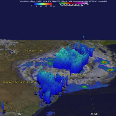
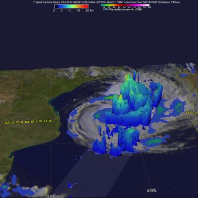
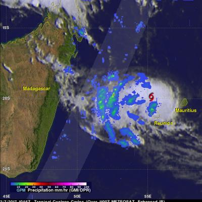
Tropical Cyclone's Remnants Examined By GPM

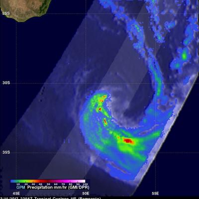
The GPM core observatory satellite flew above the remnants of tropical cyclone 11S on March 14, 2017 at 2356 UTC. The remnants were located south-southeast of Madagasgar and were rapidly transforming into an extra-tropical low. GPM showed the locations of intense rainfall still being produced by the low. GPM's Dual-Frequency Precipitation Radar (DPR) data showed that rain was falling at a rate of over 205 mm (8 inches) in a few storms. GPM's radar (DPR Ku Band) found that some storm tops in the remnants were reaching heights above 13 km (8 miles). GPM satellite radar (DPR Ku Band) data were

Tropical Cyclone Enawo's Rainfall Totals Updated With IMERG

Tropical cyclone Enawo is now responsible for the deaths of at least five people in Madagascar. Many thousands of people were also displaced due to flooding and destroyed homes. The tropical cyclone dropped heavy rainfall as it soaked the island from north to south. This rainfall analysis was updated to include recent precipitation estimates from NASA's Integrated Multi-satelliE Retrievals for GPM (IMERG) rainfall data. It shows rainfall estimates from IMERG data collected during the period from March 3-10, 2017. As expected, the eastern side of Madagascar had the highest rainfall total

Deadly Tropical Cyclone Enawo Drenches Madagascar

Tropical cyclone Enawo hit Madagascar on Tuesday with powerful winds and drenching rain. At least three people have been reported killed by the tropical cyclone. Floods and landslides are likely as Enawo moves southward down the center of Madagascar. Tropical cyclones rotate in a clockwise direction in the southern hemisphere so the eastern side of Madagascar will have a strong onshore flow. The extreme amount of moisture flowing onto Madagascar from the Indian Ocean is expected to produce flooding and landslides. NASA's Integrated Multi-satelliE Retrievals for GPM (IMERG) data are produced

Powerful Tropical Cyclone Enawo Threatens Madagascar

Tropical cyclone Enawo has continued to intensify while moving toward Madagascar. Enawo had winds of about 90 kts (103.5 mph) when the GPM core observatory satellite flew over on March 6, 2017 at 0306 UTC (0606 AM local time). These powerful winds make Enawo the equivalent of a category two hurricane on the Saffir-Simpson Hurricane wind scale. GPM revealed that the tropical cyclone had heavy rainfall in distinct feeder bands on the western side and in the northeastern side of the eyewall. Precipitation was measured by GPM's DPR falling at a rate of over 220 mm (8.7 inches) per hour in intense

GPM Examines Deadly Tropical Cyclone Dineo

Dineo has now weakened to a tropical depression but the tropical cyclone had winds of over 70 kts (80.5 mph) when it hit Mozambique. Four people have been reported killed by Dineo. The GPM core observatory satellite flew over Mozambique on February 16, 2016 at 0916 UTC after Dineo's maximum sustained winds had fallen to about 60 kts (69 mph). Data collected by GPM's Microwave Imager (GMI) and Dual-Frequency Precipitation Radar (DPR) instruments showed that the tropical cyclone was still dropping light to moderate rainfall over a large area of southern Mozambique. This GPM view revealed that

Intensifying Tropical Cyclone Dineo Seen By GPM

Tropical cyclone Dineo was intensifying in the middle of the Mozambique Channel when the GPM core observatory satellite flew over on February 14, 2017 at 0926 UTC. Dineo had winds of about 55 kts (~ 63.3 mph) at the time of this GPM pass. Very heavy precipitation was found in feeder bands on Dineo's northeastern side. The most intense rainfall was measured by GPM's Dual-Frequency Precipitation Radar (DPR) falling at a rate of over 132 mm (5.2 inches) per hour in the intense storms in the northeastern quadrant of the tropical cyclone. GPM's radar (DPR Ku Band) sliced through the center of

GPM Sees Carlos Moving Past Reunion Island

The GPM core observatory satellite flew above tropical cyclone Carlos on February 7, 2017 at 1056 UTC. Carlos was moving past Reunion Island with maximum sustained winds estimated at 45 kts (51.8 mph). GPM's Microwave Imager (GMI) and Dual-Frequency Precipitation Radar (DPR) data show that rain bands west of Carlos' center were producing heavy rainfall. GPM's DPR swath is shown in a lighter shade. DPR measured a few downpours in the bands west of the Carlos' center of circulation dropping rain at a rate of over 120 mm (4.7 inches) per hour. GPM's radar (DPR Ku Band) found that a few storm tops

GPM Sees Possible Tropical Cyclone Developing Near Australia

So far this year no tropical cyclones have developed in the Southwest Indian Ocean. The Joint Typhoon Warning Center (JTWC) recently warned that a low moving westward over northwestern Australia may soon become a tropical cyclone. Warm Indian Ocean waters and low vertical wind shear are providing a good environment for tropical cyclone development. The GPM satellite flew over northwestern Australia on January 25, 2017 at 2351 UTC. GPM's Microwave Imager (GMI) and Dual-Frequency Precipitation Radar (DPR) measured precipitation within strong convection in the Indian Ocean northwest of the lows

GPM Finds Rainfall Increasing With Tropical Cyclone Yvette

The GPM core observatory satellite again flew over tropical cyclone Evette (02S), located off the northwestern coast of Australia, on December 21, 2016 at 0941 UTC. Maximum sustained winds had increased to about 40 kts (46 mph). The GPM satellite's Microwave Imager (GMI) revealed that the area of continuous rainfall around Yvette's center of circulation had increased in size. Convective storms were shown by GPM to be dropping rain at rates of over 60 mm (2.4 inches) per hour. Tropical cyclone Yvette is predicted to intensify slightly by tomorrow to about 50 kts (58 mph). Yvette continues to be

Tropical Cyclone 02S Formation Observed By GPM

Australia is normally affected by 11 cyclones a year but only three formed during Australia's last summer. This year sea surface temperatures in the tropical waters around Australia are much warmer so an average tropical cyclone is forecast by the Bureau of Meteorology (BOM). Tropical cyclone 02S formed in the Indian Ocean northwest of Australia yesterday. Another tropical cyclone is also expected to form soon in an area of intense convection west-northwest of Darwin, Australia. The GPM core observatory satellite flew above tropical cyclone 02S just a few hours after it's formation on December