tropical cyclones

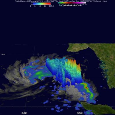
GPM Sees Tropical Cyclone Vardah (05B) Intensifying

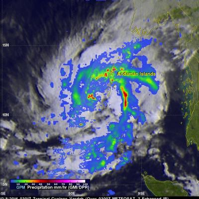
The GPM core observatory satellite had another excellent view of tropical cyclone Vardah (05B) in the eastern Bay of Bengal on December 8, 2016 at 0301 UTC. GPM found that Vardah had become better organized since it formed on December 7, 2016. Maximum sustained winds had increased to an estimated 45 kts (~52 mph). GPM's Microwave Imager (GMI) showed that two intense feeder bands were bringing moisture from the Andaman Sea into the northeastern side of the tropical cyclone. GPM's Dual-Frequency Precipitation Radar (DPR) coverage is shown in a slightly lighter shade through the center of the

Forming Tropical Cyclone Examined By GPM

A tropical cyclone (TC05b) formed on December 7, 2016 in the eastern Bay Of Bengal. The Joint Typhoon Warning Center (JTWC) issued it's first advisory when TC05B was located just west of the Andaman and Nicobar Islands with winds of 35kts (~40 mph). On December 6, 2016 at 1441 UTC the GPM core observatory satellite passed over the forming tropical cyclone. This image shows a rainfall analysis that was derived from GPM's Microwave Imager (GMI) and Dual-Frequency Precipitation Radar (DPR) data. GPM's radar (DPR Ku band) showed that the forming tropical cyclone had two bands of convective storms
GPM Takes Parting Look At Hermine JacobAdmin Wed, 09/07/2016
Post Tropical Cyclone Hermine was still rotating in the Atlantic Ocean east of New Jersey when the the GPM core observatory satellite flew above on September 6, 2016 at 2:05 PM EDT ( 1806 UTC). Hermine's power was greatly dissipated from the hurricane that hit Florida on September 2, 2016. Hermine still had maximum sustained winds of about 58 mph (50 kts). Hermine was also still producing some light to moderate showers. Precipitation data shown here were derived from GPM's Microwave Imager (GMI) and Dual-Frequency Precipitation Radar (DPR) instruments. Those data showed that rain was falling
Increased Western Pacific Tropical Cyclone Activity Seen By GPM JacobAdmin Fri, 08/19/2016
The first typhoon in the western Pacific Ocean (NEPARTAK) didn't form until July this year. Since then tropical cyclone activity has increased with four of the named tropical cyclones coming near Japan. Typhoon Chantu recently brought strong winds and heavy rain to northern Japan. Tropical storm Lionrock quickly followed Chantu and is predicted to strengthen little while moving past to the south of Japan. Another tropical storm called Mindulle formed today in the Pacific Ocean northwest of Guam. Mindulle is predicted to move northward, intensify and become a typhoon just before hitting

GPM Observes Tropical Storm Ivette

On August 2, 2016 Ivette became the 11th tropical cyclone this year in the eastern Pacific. Tropical cyclones have formed in the eastern Pacific this year at almost the same frequency as in 2015. Ivette has been moving toward the central Pacific Ocean. Warm ocean water and low vertical wind shear are expected to help Ivette intensify to hurricane intensity in a few days. The GPM core observatory passed over the eastern side of tropical storm Ivette on August 4, 2016 at 0606 UTC. GPM's Microwave Imager (GMI) and Dual-Frequency Precipitation Radar (DPR) data showed that storms around Ivette

IMERG Shows Darby's Rainfall Over The Hawaiian Islands

Most of the Hawaiian Islands were spared serious damage from tropical storm Darby. The location of Darby's track through the Hawaiian Islands resulted in the islands of Hawaii and Oahu being the most affected. Flash flooding was common on Oahu due to a reported 177.8 mm (7 inches) of rain drenching the island. Interstate H-1 was flooded in some locations. Lightning damage was reported in Kaneohe on the windward side of Oahu. Estimates of rainfall accompanying tropical storm Darby were produced using NASA's Integrated Multi-satellitE Retrievals for GPM (IMERG) data. These IMERG rainfall

GPM Sights Another Forming Tropical Cyclone

The eastern Pacific Ocean continues to spawn tropical cyclones. Seven named tropical cyclones have already formed in the Eastern Pacific ocean this year. The National Hurricane Center (NHC) has indicated that another tropical cyclone is likely to form in a broad area of low pressure southwest of Acapulco, Mexico. The GPM core observatory satellite flew directly above this increasingly organized stormy area on July 21, 2016 at 0851Z. GPM found that powerful thunderstorms in that area contained intense showers. Rain was measured by GPM's Dual-Frequency Precipitation Radar (DPR) instrument

Southern Hemisphere Tropical Cyclone Abela Viewed By GPM

Tropical cyclone 01S (Abela) formed in the South Indian Ocean on July 16, 2016. Abela was the first tropical Cyclone to form in July over the South Indian Ocean since 2007 so it is a little unusual. The GPM core observatory satellite recently had two good views of Abela. GPM saw the newly formed tropical cyclone on Jul 16, 2016 at 2216 UTC. Precipitation data collected by GPM's Microwave Imager (GMI) and Dual-Frequency Precipitation Radar (DPR) instruments showed that ABELA contained a large area of rainfall on July 16, 2016. Then again on July 18, 2016 at 2206 the satellite passed above after

GPM Sees Bonnie as a Tropical Depression Again

Tropical storm Bonnie weakened to a tropical depression on May 29, 2016. The circulation was labeled as "Post-Tropical" and has been moving very slowly to the northeast near the Carolinas coastline. Bonnie developed organized convection near the center and the system has again been labeled a tropical depression. The GPM core observatory satellite saw Tropical Depression Bonnie on June 1, 2016 at 2226 UTC (6:26 PM EDT). GPM's Microwave Imager (GMI) and and Dual-Frequency Precipitation Radar (DPR) instruments measured precipitation in a few powerful convective thunderstorms falling at a rate of

GPM Examines Tropical Depression Bonnie In The Carolinas

The GPM core observatory satellite had an excellent view of Tropical Depression Bonnie as it flew over the southeastern United States on May 29, 2016 at 2326 UTC (7:26 PM EDT). Rainfall was analyzed using data collected by GPM's Microwave Imager (GMI) and and Dual-Frequency Precipitation Radar (DPR) instruments. GPM's radar (DPR) showed rain falling at a rate of over 25.4 mm (1 inch) per hour in South Carolina. GPM's Radar (DPR Ku Band) was able to see through cloud cover in the tropical depression and show the vertical shape of rain within storms. The heights of storm tops were derived from