tropical depressions

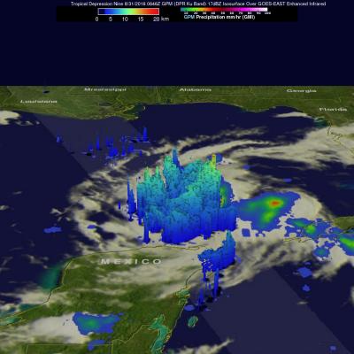
GPM Sees Potential Tropical Depression Developing In The Gulf Of Mexico

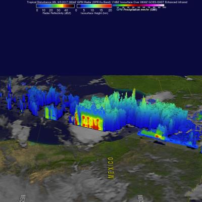
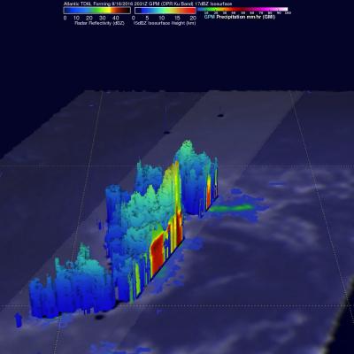
The GPM Core Observatory satellite had an excellent view of a potential tropical depression developing in the Gulf Of Mexico on September 5, 2017 at 3:34 AM CDT (0834 UTC). GPM found that powerful convective storms were dropping heavy rainfall in the Gulf of Mexico east Mexico's coast. GPM's Dual-Frequency Precipitation Radar (DPR) instrument measured rain falling at a rate of over 9.2 inches (233 mm) per hour in an intense band of storms. GPM's Radar (DPR Ku Band) data was used to examine the 3-D structure of precipitation in this area of strong convective storms. GPM's DPR showed that storm

Tropical Depression 03W In The Pacific Examined By GPM

Tropical Depression 03W formed in the Pacific Ocean west of Guam on April 24, 2017. The GPM core observatory satellite had an excellent view of TD03W when it flew over on April 14, 2017 at 1901 UTC. The GPM satellite found that the newly formed tropical depression contained some very powerful convective storms. Intense storms in the middle of the organizing convective cluster were dropping precipitation at extreme rates. GPM's Microwave Imager (GMI) and Dual-Frequency Precipitation Radar (DPR) instruments unveiled tall convective storm towers on the eastern side of this cluster of storms that

Tropical Depression MA-ON Evaluated With GPM Data

Tropical cyclones have been forming frequently in the Western Pacific Ocean since July 2016. 36 named tropical cyclones have formed in the Western Pacific in less than 5 months with 14 of them becoming typhoons. Tropical Depression MA-ON Formed on November 10, 2016 northeast of Guam. MA-ON had maximum sustained winds estimated at 30 kts (34.5 mph) when the GPM core observatory satellite flew over on November 10, 2016 at 0701Z. GPM's Microwave Imager (GMI) and Dual-Frequency Precipitation Radar (DPR) instruments showed that the tropical depression contained some very heavy showers. Strong bands

GPM Views Still Energetic Tropical Depression Karl

Tropical Depression Karl's strength has fluctuated. Karl formed on September 14th in the eastern Atlantic, strengthened to tropical storm intensity on September 16th and was downgraded to a tropical depression yesterday. The GPM core observatory satellite had an outstanding view of Karl when it passed above today at 1201 UTC (8:01 AM EDT). Data collected by GPM's Microwave Imager (GMI) and Dual-Frequency Precipitation Radar (DPR) instruments uncovered heavy rainfall inside storms within the tropical depression. DPR found that powerful convective storms near Karl's center of circulation were

Intensifying Tropical Depression Nine Checked By GPM

The National Hurricane Center (NHC) expects Tropical Depression Nine to intensify over the next day or so. Vertical wind shear is predicted to be low and the tropical depression is moving over warmer water. Both of these factors will provide fuel for intensification. The GPM core observatory satellite scanned the tropical depression on August 31, 2016 at 2:46 AM EDT (0646 UTC). GPM's Microwave Imager (GMI) and Dual-Frequency Precipitation Radar (DPR) instruments saw heavy rainfall in strong convective storms in the Gulf Of Mexico northwest of Cuba. GPM's DPR found that some of these intense

Tropical Depression Nine Forms

The frequency of tropical cyclone formation has definitely increased in the Atlantic Ocean basin. A tropical wave that the National Hurricane Center (NHC) had been monitoring for development since it left the African coast almost two weeks ago was upgraded to Tropical Depression Nine (TD09L) on August 28, 2016. The low pressure became a little better organized after moving into the Florida Strait and that led to the upgrade. The GPM core observatory satellite passed above the still relatively poorly organized tropical depression on August 29, 2016 at 2:56 AM EDT (0656 UTC). Maximum sustained

GPM Satellite Sees Forming Atlantic Tropical Depression

Tropical Depression Six (TD06L) formed in the Eastern Atlantic Ocean southwest of the Cape Verde Islands late Tuesday evening. TD06L has become better organized today. The National Hurricane Center (NHC) predicts that the tropical depression will intensify and become tropical storm Fiona later today. The tropical storm is predicted to become slightly more powerful while moving toward the northwest over the open waters of the central Atlantic. The GPM core observatory satellite collected data when TD06L was forming on August 16, 2016 at 2031 UTC. GPM data showed that the forming tropical

GPM Observes Newly Formed Tropical Depression Eight-E

The eastern Pacific Ocean continues to show that it's environment is favorable for the birth of tropical cyclones. Tropical Depression EIGHT-E (TD08E) quickly followed tropical storm FRANK as the latest example of tropical cyclogenesis in the eastern Pacific Ocean. The GPM core observatory satellite examined TD08E when it flew directly above on July 22, 2016 at 0931 UTC. At that time maximum sustained winds were only estimated to be about 30 kts (34.5 mph). Rainfall was examined in TD08E using data collected by GPM's Microwave Imager (GMI) and Dual-Frequency Precipitation Radar (DPR)

GPM Sees Tropical Depression SIX-E Forming

A large area of low pressure in the eastern Pacific Ocean was sufficiently organized and developed that the National Hurricane Center (NHC) designated it as tropical depression SIX-E on July 15, 2016 at 1500Z (9:00 AM MDT). With the development of tropical depression SIX-E there are currently three active tropical systems in the eastern Pacific Ocean. The GPM core observatory had a good view of forming tropical depression SIX-E when it flew over on July 15, 2016 at 1056 UTC (4:56 AM MDT). Precipitation data were calculated from data collected by GPM's Microwave Imager (GMI) and Dual-Frequency

GPM Sees Tropical Depression Bonnie In The Atlantic

The GPM core Observatory had another good look at revived tropical Depression Bonnie on June 3, 2016 at 0716 UTC (3:16 AM EDT). Rainfall calculated from data received by GPM's Microwave Imager (GMI) and and Dual-Frequency Precipitation Radar (DPR) instruments are shown in the first image. Those instruments found that Bonnie was dropping rain at a rate of over 65 mm (2.6 inches) per hour in storms south of the depression's center of circulation. GPM's Radar (DPR Ku Band) again measured the 3-D structure of rainfall within Bonnie and found that some storms were reaching heights of over 13 km (8