tropical storms

GPM Overpass of Tropical Cyclone Fred on August 16, 2021.
Tropical Storm Fred, the 6th named storm of the 2021 Atlantic hurricane season, began as a westward moving disturbance in the central Atlantic east of the Lesser Antilles. The system passed through the southern Leeward Islands during the early morning hours of August 10 but still lacked a well-defined center of circulation. Despite significant thunderstorm activity within the system, it wasn’t until late that evening, when the system was passing just south of Puerto Rico, that the National Hurricane Center (NHC) identified a well-defined circulation and upgraded the system to Tropical Storm
IMERG Rainfall Rates and MUR Sea Surface Temperatures from the 2020 Hurricane Season
Forecasters predicted an above-normal hurricane season for 2020. They weren’t wrong. As the 2020 Atlantic hurricane season smashed records with an unprecedented 30 named storms , NASA’s Earth Applied Sciences Disasters Program stood up to the challenge. The Disasters Program helps leaders and responders at national, regional, and local levels leverage NASA’s technology and expertise to assess, predict, and understand disasters' impacts. The Disasters Program targets a wide range of hazards and disasters , and while NASA is not an operational response agency, the agency offers access to unique
Hurricane Eta over Florida
After striking the northeast coast of Nicaragua as a powerful Category 4 storm back on November 3, Hurricane Eta weakened rapidly over Central America but still brought major flooding and triggered numerous landslides that so far have resulted in at least 250 fatalities across the region, according to media reports. Eta was down to a tropical depression when the center re-emerged over the northwestern Caribbean on the evening of November 5. An upper-level trough over the Gulf of Mexico first steered Eta northeastward towards Cuba on the 6th. Because it was disorganized after its trek across

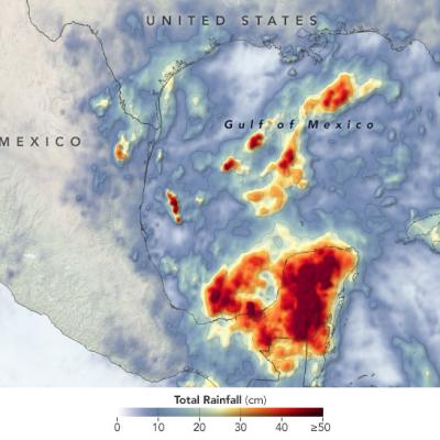
Short-lived Bertha Brings Heavy Rains to Parts of Florida

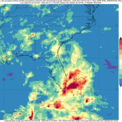
Bertha was a named storm for just the briefest of periods, becoming a tropical storm on the morning of Wednesday May 27th at 8:30 am EDT just one hour before it made landfall along the South Carolina coast near Charleston. After making landfall, Bertha quickly weakened into a tropical depression and was then accelerated northward by the southerly flow between a deep trough of low pressure over the Mississippi Valley to the west and a ridge of high pressure located just off the US East Coast. Because of this, rainfall totals over the Carolina’s were not very heavy. Bertha’s biggest impact actually occurred when it was still in the formation process, before it became organized enough to be named. On Monday May 25th, a trough of low pressure became established over the Florida Straits, initiating shower and thunderstorm activity in the region. Over the next day, as this trough, which extended eastward over the warm waters of the Gulf Stream and eventually led to Bertha, slowly moved northward up the Florida peninsula, it provided a focus for showers and thunderstorms, which brought heavy rains to southeast Florida.

Cristobal Drenches Central America

The 2020 Atlantic hurricane season is off to a busy start. By the first week of June, Tropical Storm Arthur had already brushed North Carolina , Tropical Storm Bertha had drenched South Carolina , and the third named storm of the year— Cristobal—was dropping torrential rain on the Yucatán Peninsula. The storm first developed in the Pacific in late May as Tropical Storm Amanda, spinning off the southern end of a seasonal low-pressure pattern called the Central American Gyre . After making landfall in Guatemala and causing deadly floods in El Salvador , Amanda weakened and became less organized

GPM Sees Developing Tropical Storm Barry in the Gulf of Mexico

NASA / JAXA’s GPM Core Observatory passed over developing Tropical Depression 2 (which was upgraded to Tropical Storm Barry later in the morning) in the Gulf of Mexico the morning of July 11th 2019 at 8:26am CT, capturing estimates of rainfall rates within the storm. The first image shows rainfall rates collected by GPM’s Microwave Imager, while the second image shows 3D rainfall rates within the atmospheric column from GPM’s Dual-frequency Precipitation Radar (DPR). The DPR measured storm top heights as high as 18 km, which is extremely high and indicative of intense thunderstorm activity

NASA's IMERG Used To Analyze Tropical Storm Usagi's Rainfall

Usagi strengthened to hurricane intensity as it approached Vietnam from the South China Sea but weakened to tropical storm intensity when coming ashore. Very heavy rainfall and damaging winds accompanied tropical storm Usagi when it hit Vietnam's southern coast. More than 350 mm (14 inches) of rainfall was reported causing widespread flooding around Ho Chi Minh City. NASA's Integrated Multi-satellitE Retrievals for GPM (IMERG) data were used to show estimates of rainfall accumulation produced by Usagi as the tropical cyclone moved across the South China Sea into Southeast Asia. This IMERG

GPM Probes Tropical Storm Isaac

Hurricane Florence, tropical storm ISAAC and hurricane Helene are currently active in the Atlantic Ocean. Tropical storm ISAAC is the next tropical cyclone to affect the western Atlantic. It is moving westward toward the Leeward and Windward Islands. The National Hurricane Center (NHC) predicts that ISAAC will pass through the Leeward and Windward Islands and move into the Caribbean Sea over the next few days. The NHC predicts that ISAAC will weaken as it encounters moderate vertical shear and nearby dry air. The GPM core observatory satellite had an excellent view of tropical storm ISAAC on

Tropical Storm Gordon's Rainfall Measured With IMERG

Tropical Storm Gordon became the seventh named system of the 2018 Atlantic hurricane season on Monday September 3, 2018. GORDON became more intense as it moved through the eastern Gulf Of Mexico but didn't quite make it to hurricane force before landfall. GORDON was a strong tropical storm with winds of about 70 mph (~ 61 kts) when it hit southeastern Mississippi on September 5, 2018. GORDON continued to produce rainfall as it moved inland. Weakening GORDON spawned a tornado near Picayune, Mississippi on Thursday September 6, 2018. Today, tropical depression GORDON is still responsible for

Tropical Storm Miriam's Formation Observed by GPM

Tropical cyclone's continue to regularly develop in the eastern Pacific Ocean. Tropical Depression Fifteen-E formed in the eastern Pacific Ocean about 1000 nautical miles (1852 km) southwest of the Baja California peninsula early on Sunday August 26, 2018. TD15E became better organized with increased banding later in the day and was upgraded by the National Hurricane Center (NHC) to tropical storm MIRIAM. The GPM core observatory satellite saw the forming tropical storm earlier on August 26, 2018 at 0223 UTC. Heavy rainfall near the center of the forming tropical cyclone was examined with the