tropical storms

Tropical Storm 14W Examined By The GPM Satellite

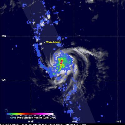
Tropical storm 14W formed in a remote area of the western Pacific Ocean southeast of Wake Island on August 11, 2017. The GPM core observatory satellite flew above the center of the newly formed tropical storm on August 11, 2017 at 0902 UTC. The "core" satellite carries advanced radar and radiometer systems that measure precipitation from space and serves as a standard that is used to unify precipitation measurements from a constellation of research and operational satellites. Tropical storm 14W was revealed by GPM to be small but well organized with very intense convective storms near the

More Organized Tropical Storm Gert's Rainfall Examined by GPM

The GPM core observatory satellite passed above tropical storm Gert on August 14, 2017 at 9:36 EDT (1336 UTC) when winds had reached about 57.5 mph (50 kts). Data collected by GPM's Microwave Imager (GMI) and Dual-Frequency Precipitation Radar (DPR) instruments were used to show the coverage and the intensity of rainfall arround tropical storm Gert. The area covered by GPM's radar swath (shown in lighter shades) revealed that the most intense rainfall, measuring greater than 3.5 inches (90 mm) per hour, was located in bands of rain on the eastern side of the storm. This GPM pass was mentioned

GPM Sees Intensifying Tropical Storm Franklin

The GPM core observatory satellite had an informative pass over Tropical storm Franklin on August 9, 2017 at 0302 UTC. The intensifying tropical storm had moved from Mexico's Yucatan Peninsula into the southwestern Gulf Of Mexico's Bay of Campeche. GPM's Microwave Imager (GMI) and Dual-Frequency Precipitation Radar (DPR) data showed that Franklin contained a few heavy bands of convective rainfall. GPM's DPR found rain falling at a rate of over rain 2.4 inches (62 mm) per hour in bands of intense storms moving around the southwestern side of the storm. This 3-D view of tropical storm Franklin

Forming Tropical Storm Don's Rain Checked By GPM

On Monday July 17, 2017 at 5:00 PM EDT a tropical disturbance in the Atlantic Ocean was upgraded to tropical storm Don, the fourth Atlantic Tropical storm of 2017. The GPM core observatory satellite flew above the forming tropical storm much earlier in the same day at 3:17 AM EDT (0717 UTC). GPM's Microwave Imager (GMI) and Dual-Frequency Precipitation Radar (DPR) instruments collected data that were used to evaluate precipitation within the forming tropical cyclone. GPM's Radar data swath (shown in lighter shades) covered an area to the west of the greatest amount of rainfall. GPM's radar

Weakening Tropical Storm Eugene Investigated With GPM Satellite

The GPM core observatory satellite had another excellent view of Eastern Pacific tropical storm Eugene on July 11, 2017 at 0231 UTC. Eugene was weakening as it traveled toward the northwest over progressively cooler waters. The only remaining strong convective activity was seen in Eugene's northwestern quadrant. GPM's Dual-Frequency Precipitation Radar (DPR) data revealed that some of these convective storms northwest of Eugene's center of circulation were dropping rain at a rate of more than 70 mm (2.8 inches) per hour. A 3-D view of the dissipating tropical storm was developed using GPM's

NASA's IMERG Shows Cindy's Extreme Rainfall

Tropical storm Cindy was downgraded to a tropical depression after moving onshore near the Texas and Louisiana Border on Thursday June 22, 2017. Flooding was reported along the the Gulf Coast even before Cindy made landfall. The rainfall around tropical storm Cindy was asymmetrical. The majority of heavy rainfall with the tropical cyclone was located east of Cindy's center in the states along the Gulf Coast from Louisiana through the Florida Panhandle. The tropical depression continued to spread heavy rain and occasionally severe thunderstorms after it came ashore. Severe thunderstorms spawned

GPM Observes Tropical Storm Merbok

Tropical storm MERBOK formed in the South China Sea west of the Philippines on June 11, 2017. The GPM core observatory satellite flew above MERBOK on June 10, 2017 at 0631 UTC when the tropical storm was forming. GPM's Microwave Imager (GMI) and Dual-Frequency Precipitation Radar (DPR) showed that the future tropical storm was starting to get organized. Feeder bands were shown converging into the center of the circulation located in the South China Sea west of Luzon. GPM passed over the western side of tropical storm MERBOK again on June 12, 2017 at 0621 UTC when it's maximum sustained winds

GPM Monitors Tropical Cyclone Donna

The above window displays an interactive visualization of GPM data collected from Tropical Cyclone Donna on 5/7/17. Over the weekend tropical cyclone Donna dropped very heavy rain over Vanuatu as it moved toward the west of the islands. Donna had intensified and had maximum sustained winds of 115 kts (132 mph) on Monday morning. This made it the equivalent of a category four on the Saffir-Simpson hurricane wind scale. The GPM core observatory satellite had two excellent views of the intensifying tropical cyclone Donna on succeeding days. When GPM flew over Donna on May 6, 2017 at 0146 UTC the

GPM Satellite Reveals Intensity Of Powerful Storms In The Timor Sea

The GPM satellite flew over a stormy area of the Timor Sea northwest of Australia on February 7, 2017 at 1926Z. GPM found that this stormy area contained some extremely powerful convective storms. GPM's Dual-Frequency Precipitation Radar (DPR) found that the most intense storms were dropping rain at a rate of over 268 mm (10.6 inches) per hour. Data received by GPM's Radar (DPR Ku Band) also revealed the 3-D anatomy of precipitation hidden inside these unusually powerful storms. GPM's radar found that these storm tops were pushing to altitudes greater than 19 km (11.8 miles). GPM radar data

Tropical Storm Carlos Forms

Tropical storm Carlos formed in the Southwest Indian Ocean north of the French Islands of Reunion and Mauritius on February 4, 2017 (UTC). This ended an unusual drought of tropical cyclone formation in that part of the Indian Ocean that began in July 2016. NASA's GPM core observatory satellite flew above tropical storm Carlos on February 5, 2017 at 1056 UTC when Carlos had maximum sustained winds of about 45 kts (51.8 mph). GPM collected data that showed the intensity and structure of precipitation within Carlos. GPM's Dual-Frequency Precipitation Radar (DPR) measured rain falling at a rate of