tropical storms

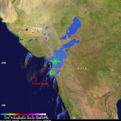
GPM Sees Ockhi's Rain Reaching India's Western Coast

NASA's GPM Core Observatory satellite passed over western India on December 5, 2017 at 0521 UTC. GPM's Microwave Imager (GMI) and Dual-Frequency Precipitation Radar (DPR) instruments showed precipitation from dissipating tropical cyclone OCKHI reaching India's western coast. GPM's radar (DPR Ku band) indicated that rain was falling at a rate of over 101.6 mm (4 inches) per hour in a few storms near India's coast. OCKHI's low level center of circulation, shown with a red tropical cyclone symbol, was located well to the southwest of the storms that were moving onto India's western coast. This 3

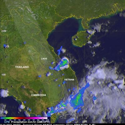
GPM Sees Remnants Of Tropical Storm Haikui Affecting Vietnam

The GPM core observatory satellite provided information about rainfall associated with the remnants of tropical storm Haikui on November 2017 at 0929 UTC. Earlier this month, typhoon Damrey caused widespread destruction when it hit Vienam on November 4, 2017. Fortunately tropical storm Haikui dissipated over the South China Sea before it reached Vietnam. Rainfall data collected by GPM's Microwave Imager (GMI) and Dual Frequency Precipitation Radar (DPR) instruments revealed that some storms with tropical storm Haikui's remnants contained light to moderate precipitation. A small cluster of

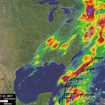
IMERG Measures Rainfall From Tropical Storm Philippe Plus Northeast Low

NASA's Integrated Multi-satellitE Retrievals (IMERG) data were used in this analysis to show total rainfall accumulation estimates during the period from October 27 - 31, 2017. Tropical storm Philippe formed and dissipated during that period. The tropical storm formed over the western Caribbean from tropical depression eighteen on October 28, 2017. Philippe then drenched western Cuba as it moved toward the northeast. It dropped a reported 10 inches (254 mm) of rain over southeastern Florida before dissipating in the Atlantic Ocean. Moisture from Philippe's remnants added to heavy rainfall

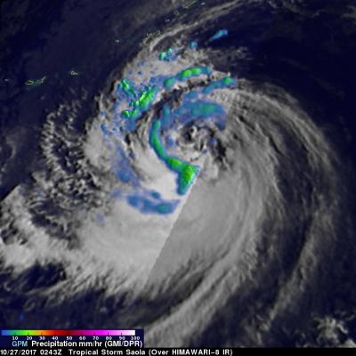
GPM Measures Tropical Storm Saola's Rainfall

The GPM core observatory had a fairly good view of tropical storm Saola on October 27, 2017 at 0243 UTC. This image shows the GPM satellite's coverage (lighter shades) of surface rainfall around tropical storm Saola. GPM's Microwave Imager (GMI) and Dual-Frequency Precipitation Radar (DPR) instruments received data showing the intensity of rainfall over the western half of tropical storm Saola. GPM's radar (DPR Ku Band) discovered that rain was falling at a rate of over 66 mm (2.6 inches) per hour in feeder bands wrapping around that side of the tropical storm. The most intense convective

Strengthening Tropical Storm Ophelia Observed By GPM

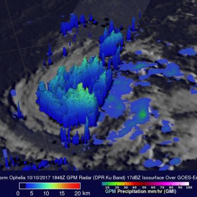
On Monday October 9, 2017 at 1100 AM AST (1500 UTC) tropical depression seventeen (TD17) was upgraded to tropical storm Ophelia. The tropical storm is located over the open waters of the the eastern Atlantic southwest of the Azores. The GPM core observatory satellite had a good view of tropical storm Ophelia on October 10, 2017 at 2:46 PM AST (1846 UTC). GPM's Microwave Imager (GMI) and Dual-Frequency Precipitation Radar (DPR) revealed that the storm was organized but most of the rainfall in the storm was only of light to moderate intensity. The area covered by GPM's 151.9 mile wide (245 km)

GPM Examines Forming Tropical Storm Nate (TD16)

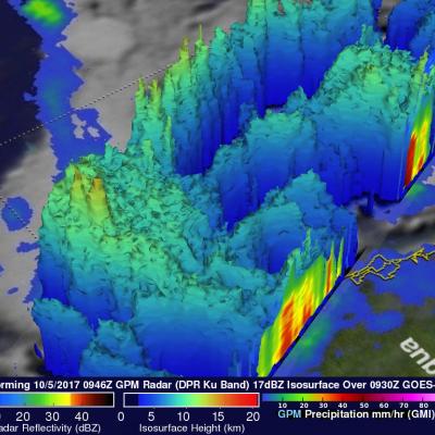
The GPM core observatory satellite passed above forming tropical storm Nate (TD16) on October 5, 2017 at 5:46 AM EDT (0946 UTC). TD16 was located in the western Caribbean near the coast of Nicaragua with winds of about 34.5 mph (30 kts). Data received by GPM's Microwave Imager (GMI) and Dual-Frequency Precipitation Radar (DPR) shows bands of rain producing heavy rainfall East of TD16's center of circulation. Downpours in the Caribbean Sea East of Nicaragua were measured by GPM's Radar (DPR Ku Band) dropping rain at a rate of over 6.4 inches (162 mm) per hour. This close-up 3-d cross section

Intensifying Tropical Storm Jose

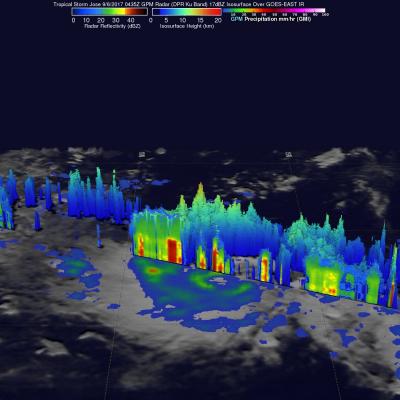
On September 5, 2017 tropical Storm Jose became the tenth named storm of the Atlantic hurricane season. The GPM core observatory satellite passed above the intensifying tropical cyclone on September 6, 2017 at 00:45 AM AST (0435 UTC). Data collected by GPM's Microwave Imager (GMI) at that time showed that weak bands of rain were starting to develop around Jose's center of circulation. GPM's Dual-Frequency Precipitation Radar (DPR) data swath revealed the location of heavy rain in a feeder band on Jose's western side. DPR found that rain in this area was falling at a rate of over 5.3 inches

GPM Satellite Sees Tropical Storm Irma Forming Near Cape Verde Islands

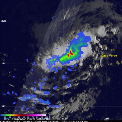
The National Hurricane Center (NHC) upgraded a low pressure area in the far eastern Atlantic Ocean to tropical storm Irma on August 30, 2017 at 11:00 AM AST (1500 UTC). Tropical cyclones that form in that part of the Atlantic Ocean are often the largest and most powerful hurricanes of the season. Hurricanes Ivan (2004), Isabel (2003), Hugo (1989) and Allen (1980) are examples of past powerful hurricanes that formed near the Cape Verde islands. The GPM core observatory satellite flew above forming tropical storm Irma on August 30, 2017 at 1:56 AM EDT (0556 UTC). This new tropical cyclone was

Reviving Tropical Storm Harvey's Remnants Observed By GPM

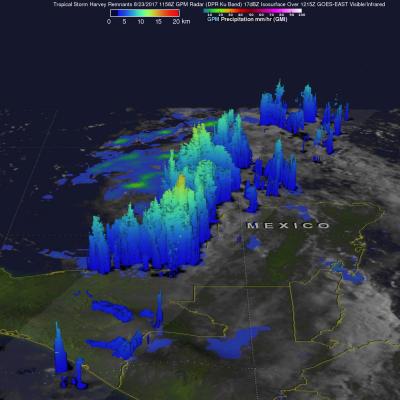
The National Hurricane Center (NHC) upgraded the remnants of tropical storm Harvey to a tropical Depression on August 23, 2017 at 10:00 AM CDT (1500 UTC). Harvey became better organized and was revived after moving from Mexico's Yucatan Peninsula into the Bay of Campeche. The warm waters of the Gulf of Mexico and favorable vertical wind shear promoted the regeneration of the tropical cyclone. The GPM core observatory satellite flew over the regenerating tropical cyclone on August 23, 2017 at 6:58 AM CDT (1158 UTC). Data collected by GPM's Microwave Imager (GMI) and Dual-Frequency Precipitation

GPM Sees New Tropical Storm Harvey

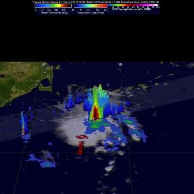
The National Hurricane Center (NHC) upgraded a tropical disturbance that they were monitoring east of the Lesser Antilles to Tropical storm Harvey on August 17, 2017 at 5:00 PM EDT (2100 UTC). The GPM core observatory satellite flew over newly designated tropical storm Harvey on August 17, 2017 at 6:21 PM EDT (2221 UTC). Easterly vertical wind shear was causing the strongest convection to be pushed to the west of the tropical storm's center of circulation. GPM's Microwave Imager and Dual-Frequency Precipitation Radar (DPR) found that some of these strong convective storms were dropping very