Cyclone Nathan Circles Back

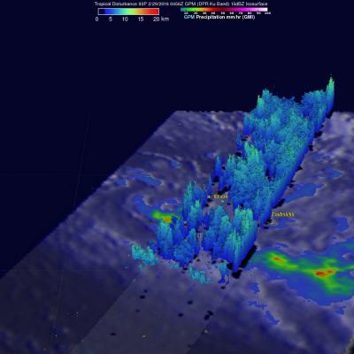
Cyclone Nathan located in the Coral Sea off Australia's Queensland coast has made another loop and is again headed slowly toward the Cape York Peninsula. Rainfall derived from the TRMM satellite's Microwave Imager (TMI) and Precipitation Radar (PR) instruments is shown with data collected on March 18, 2015 at 0758 UTC. The heaviest rainfall was measured by TRMM PR falling at a rate of over 119 mm (4.7 inches) on the eastern side of Nathan's eye. TRMM PR data were used in this 3-D view of cyclone Nathan. Storm heights in a rain band circling Nathan's northwestern side were found reaching

Cyclone Pam Departs Vanuatu

As one of the strongest cyclones every recorded in the South Pacific, Cyclone Pam devastated the island archipelago of Vanuatu. As the cyclone bore down on Vanuatu's central islands on the afternoon (local time) of March 13th, Pam's maximum sustained winds were estimated to have increased to 270 kph (~167 mph) by the US Joint Typhoon Warning Center (JTWC), making it a category 5 storm on the US Saffir-Simpson scale. The storm caused immense, widespread damage with the islands of Erromango and Tanna suffering a direct hit. Although damage is still being assessed, the number of reported

TRMM PR Data Distribution Resumes

TRMM/PR data distribution resumes during the experimental operation period. The satellite has descended to an altitude of around 350 km on February 12, 2015, which is the original nominal altitude before 2001. Verification of the data quality concluded and JAXA and PPS started distribution of PR data around the 350 km altitude (orbit number from 98231) to the public. PR available data period around 350 km altitude will be about 40 days since February 12, 2015. Please see TRMM/PR data distribution for further information and for the data locations.

Tropical Cyclone Eunice

Tropical cyclone Eunice became the fourth tropical cyclone of the 2015 Southern Indian Ocean season when it formed well east of Madagascar on January 27, 2014. Maximum sustained winds within the tropical cyclone have increased to about 85kts (~98 mph) and Eunice is predicted by the Joint Typhoon Warning Center (JTWC) to continue becoming more powerful as it travels toward the southeast. The GPM (core satellite) flew directly over the eye of newly formed tropical cyclone on January 28, 2015 at 1049 UTC. GPM's Microwave Imager (GMI) found that rain was falling at a rate of only 30.2 mm (about 1

Initial IMERG Products Released

PPS is re-releasing the first public version IMERG products The Integrated Multi-satellitE Retrievals for GPM (IMERG) merges precipitation estimates from passive microwave sensors, geo-IR, and monthly surface precipitation gauge analysis data (where available) to provide half-hourly and monthly precipitation estimates and related fields on a 0.1° lat./long. grid over the domain 60°N-S. The current period of record is mid-March 2014 to the present (delayed by about 3 months) .Please refer to the IMERG Release notes , the technical IMERG document and the IMERG Algorithm Theoretical Basis