Extreme Weather

Extreme weather news and updates.

Hurricane John (Sept 2024) IMERG rainfall accumulation
[ Goto Spanish translation; Ir a la traducción al español] On Monday evening, Sept. 23, 2024, an unusual hurricane struck southern Mexico, dumping 20 inches of rainfall along the coast according to estimates from NASA's IMERG precipitation product. The following image shows these rainfall estimates: Click here for a full resolution version of this image. Observations from an international constellation of satellites were the starting point for calculating these estimates, and the data confirm that forecasters in prior days were right to warn of possible heavy rainfall. Forecasters did have
3D map of GPM precipitation estimates from within Hurricane Francine as it approached the Gulf Coast.
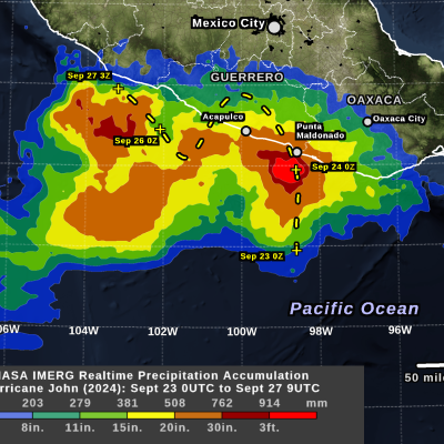
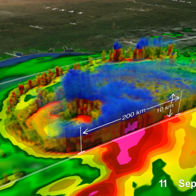
Updated: Wednesday, September 18, 2024 Hurricane Francine made landfall on Wednesday, September 11, at 5:00 p.m. CDT on the southern coast of Louisiana, approximately 30 miles south-southwest of Morgan City. The National Hurricane Center (NHC) classified it as a Category 2 storm, with maximum sustained winds estimated at 100 mph. Francine originated from a westward-moving tropical wave of low pressure, known as an African easterly wave. This wave, as is typical, emerged off the west coast of Africa before traversing the tropical Atlantic and Caribbean. These waves often serve as seedlings for
Screenshot of IMERG animation of Hurricane Beryl
On the morning of Sunday, June 30, Hurricane Beryl became a rare early season major hurricane when it reached Category 3 status with sustained winds of 115 mph as it was moving across the Atlantic 420 miles east-southeast of Barbados in the direction of the Leeward Islands. Then, just a few hours later at 11:35 a.m. EDT, Beryl became the earliest Category 4 hurricane on record in the Atlantic with sustained winds reported at 130 mph by the National Hurricane Center (NHC), surpassing Hurricane Dennis from the epic 2005 Atlantic hurricane season. Beryl also became historic as the strongest and
Screenshot of the IMERG animation showing rainfall totals from the atmospheric river in Jan. and Feb. 2024.
A pair of powerful atmospheric river events brought heavy precipitation across much of coastal California this week, resulting in record rainfall totals, extensive flooding, numerous landslides, hurricane-force winds, and power outages. These types of atmospheric river events that impact the U.S. West Coast are also known as the “Pineapple Express” due to their transport of moisture up from the Tropics originating around Hawaii. The first event had the greatest impact on northern and central California. It was initiated when a large low-pressure trough located in the northeast Pacific
jasper-screenshot.png
In mid-December 2023, the far north region of Australia’s Queensland state experienced heavy precipitation and flooding as a result of Tropical Cyclone Jasper, which made landfall on December 13 north of the town of Port Douglas. The Joint Typhoon Warning Center began issuing bulletins on Jasper on December 5 as it developed into a tropical depression over the Western South Pacific Ocean. By December 7, Jasper had strengthened to a Category 4-equivalent cyclone on the Saffir-Simpson scale as it tracked southwestward. By the time it made landfall on December 13, Jasper’s winds had weakened back
GPM Overpass of Hurricane Otis
After rapidly intensifying overnight, Hurricane Otis made landfall near Acapulco, Mexico around 1:25 a.m. CDT (06:25 UTC) on Wednesday Oct. 25 as a powerful Category 5 hurricane. Otis had maximum sustained winds estimated at 165 mph by the National Hurricane Center (NHC), making it the first Category 5 as well as the most powerful storm to hit the Pacific coast of Mexico on record. Otis formed into a tropical depression (TD 18-E) on the morning of Sunday Oct. 22 about 530 miles (850 km) south-southeast of Acapulco from a broad area of low pressure. The depression was moving slowly northward
GPM Overpass of Cyclone Bolaven
Typhoon Bolaven began as a tropical depression over the West Pacific Ocean on Oct. 7, 2023. On Oct. 10, Bolaven became a Typhoon and passed over the Mariana Islands as it tracked to the northwest. Bolaven then rapidly intensified over 12 hours from a Category 1 to a Category 5 storm on the Saffir-Simpson scale, starting around 12 UTC on Oct. 10. Several factors contributed to the rapid intensification, including modest shear in the atmosphere and warm sea-surface temperatures. This animation shows precipitation within Typhoon Bolaven around the time that rapid intensification began. The global
Map of IMERG precipitation estimates from recent flooding rainfall in Greece.
On Sept. 4, 2023, a low-pressure system developed over southeastern Europe that would lead to devastating floods over Greece and other parts of the region. The system was given the name “Daniel” by local meteorological agencies. Daniel was dynamically driven by strong cyclonic flow in the upper-level winds over southeastern Europe. The upper-levels winds combined with low-level winds from the northeast which supplied moisture from the unusually warm waters of the Aegean and Black Seas to central Greece. According to satellite infrared and microwave estimates from NASA's MUR and NOAA’s OISST v2
GPM Overpass of Hurricane Idalia
After threatening much of Florida’s western coast, Hurricane Idalia made landfall Wednesday morning in the Big Bend region of Florida’s northwest coast near Keaton Beach at 7:45 a.m. EDT, Aug. 30, as a strong Category 3 storm with sustained winds reported at 125 mph by the National Hurricane Center. Idalia’s formation was somewhat unusual. Typically, when entering the heart of the hurricane season tropical storms and hurricanes form and expand eastward across the tropical Atlantic region towards Africa’s coast. However, storms occasionally still form in the western Caribbean, as was the case
GPM Overpass of Tropical Storm Franklin on Aug. 29 2023
After becoming a tropical storm in the east-central Caribbean on the afternoon of Aug. 20 and moving generally westward for two days, Tropical Storm Franklin took a northward track and struck the southern coast of the Dominican Republic south of Barahona on the morning of Aug. 23 as a moderate tropical storm with sustained winds reported at 50 mph by the National Hurricane Center (NHC). Franklin brought heavy rains and flooding to the area, resulting in landslides, power outages and at least 2 fatalities in the Dominican Republic according to media reports. After traversing the mountainous