Extreme Weather

Extreme weather news and updates.

Tropical Storm Carlos Viewed By GPM

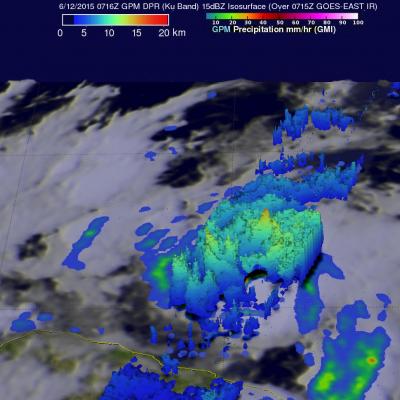
Tropical storm Carlos is the third tropical cyclone in what promises to be a busy 2015 eastern Pacific hurricane season. The GPM core observatory satellite flew directly above Carlos on June 12, 2015 at 0716 UTC. GPM's Microwave Imager (GMI) and Dual-Frequency Precipitation Radar (DPR) instruments showed that heavy rain was falling in a band of powerful storms to the southeast of the tropical storm's center of circulation. Rainfall was measured by GPM radar (Ku band) falling at a rate of almost 70 mm (2.8 inches) per hour in Carlos' most intense areas of rainfall. Those same radar data were

Tropical Cyclone Ashobaa Contains Powerful Storms

The GPM core observatory had another excellent view of tropical cyclone Ashobaa in the Arabian Sea over on June 8, 2015 at 2131 UTC. As expected, Ashobaa was more powerful than when seen by GPM earlier in the day. GPM's Microwave Imager (GMI) and Dual-Frequency Precipitation Radar (DPR) instruments showed that rain was falling at a rate of over 70.5 mm (about 2.8 inches) per hour in bands of storms west of the center of circulation. Very powerful storms were seen west of tropical cyclone Ashobaa's center of circulation by GPM's Ku Band Radar. A 3-D view constructed from GPM's Ku band radar

GPM Flys Over Tropical Cyclone In Arabian Sea

A rare tropical cyclone in the Arabian Sea west of India was seen by the GPM core observatory satellite when it flew over on the morning of June 8, 2015 at 0811Z. Tropical cyclone Ashobaa (TC01A) had sustained wind speeds of about 40 kts (46 mph) when the satellite passed over head. GPM's Microwave Imager (GMI) and Dual-Frequency Precipitation Radar (DPR) instruments measured rain falling at a rate of over 60 mm (2.3 inches) per hour in strong thunderstorms southwest of the storm's center of circulation. A 3-D view was constructed using data from DPR Ku band radar data. This 3-D view of GPM

India's Monsoon Starts

Monsoon rainfall, although a little later than normal, has started in southern India. Due to El Nino conditions India's monsoon is predicted to bring below normal rainfall this year. Cooling rainfall comes to the country after high temperatures preceding the monsoon have caused the reported deaths of over 2300 people. Data from the NASA's Integrated Multi-satellitE Retrievals for GPM (IMERG) was used in this animation to show the advent of India's monsoon. Rainfall estimates for the past few days (4-5 June 2015) show that some heavy showers have dropped over 120mm (4.7 inches) of rain in the

Hurricane Blanca Seen Traveling to Baja

After moving very little for the last few days hurricane Blanca has again started to move toward the Baja Peninsula. The GPM core observatory satellite passed directly over Blanca on June 4, 2015 at 2056 UTC when the hurricane had maximum sustained wind speeds of about 85 kts (~98 mph). GPM discovered that Blanca had very little convective rainfall in the center of a large cloudy eye. The satellite's Microwave Imager (GMI) and Dual-Frequency Precipitation Radar (Ku Band) instruments measured rain falling at a rate of over 85mm (3.3 inches) per hour in a band of powerful storms moving around

GPM Passes Over New Tropical Storm Blanka

Today a new tropical storm called Blanka formed in the eastern Pacific Ocean off southwestern Mexico. The GPM core observatory satellite flew over the forming tropical storm on June 1, 2015 at 1031 UTC (5:31 AM CDT). Rainfall data collected by GPM's Microwave Imager (GMI) and Dual-Frequency Precipitation Radar (DPR) instruments are shown The location of Blanka's center of circulation within a large area of convective thunderstorms was clearly outlined by GPM's GMI derived rainfall. A 3-D view derived from DPR's Ku Band radar data shows that several areas of intense rainfall were located east

First 2015 Tropical Storm Forms In Eastern Pacific

Tropical storm Andres became the first tropical storm of the the 2015 Eastern Pacific hurricane season today at 1500 UTC (9 AM MDT). The GPM core observatory satellite flew over the intensifying tropical cyclone (TD1E) at 1225 UTC ( 6:25 AM MDT). Rainfall data from GPM's Microwave Imager (GMI) and Dual-Frequency Precipitation Radar (Ku Band) instruments are shown overlaid on an enhanced GOES-EAST satellite infrared image received at 1230 UTC (6:30 AM MDT). Rain was found by GMI to be falling at a rate of over 60 mm (2.4 inches) per hour in powerful convective storms near Andres' center. Data

Severe Flooding Hits Central Texas, Oklahoma

A stagnant upper-air pattern that spread numerous storms and heavy rains from central Texas up into Oklahoma has resulted in record flooding for parts of the Lone Star State. One of the hardest hit areas was in Hays County Texas south of Austin where the Blanco River rose rapidly and set a new record crest at over 40 feet, 13 feet above flood stage, following a night of very heavy rain in the area, with over 12 inches reported locally in a short period of time, in an area already wet from previous storms. The combination of high pressure over the southeastern United States and a persistent

Typhoon Dolphin Weakening after Drenching Guam

Typhoon Dolphin battered and drenched the islands of Guam and Rota as it passed over the channel between them last Saturday. Luckily for Guam, Dolphin's most powerful winds occurred after passing to the northwest of Guam. By May 16, 2015 Dolphin had winds estimated at 140 kts (161 mph) making it a category five super typhoon on the Saffir-Simpson hurricane wind scale. The GPM core observatory satellite flew above the weakening typhoon early this morning when winds had dropped to less than 100 kts (115 mph). GPM's Microwave Imager (GMI) found that Dolphin was dropping rain over the open waters

Typhoon Dolphin Brushes Guam

Typhoon Dolphin passed through the Northern Marianas today just to the north of Guam with sustained winds estimated at 95 knots (~109 mph) by the Joint Typhoon Warning Center. The center passed through the Rota Channel less than about 25 iles from the northern tip of Guam, close enough for the southern half of the eye wall to rake the northern part of the island with powerful winds. A wind gust of 106 mph was reported at Andersen Air Force Base located on the northeast corner of Guam. NASA's GPM Core observatory satellite captured this image of Dolphin just as the center was exiting the Rota