Images and caption by Hal Pierce (SSAI/NASA GSFC)

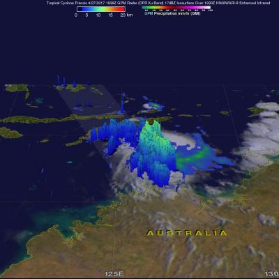
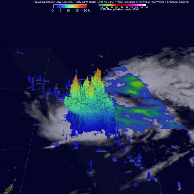
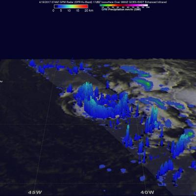
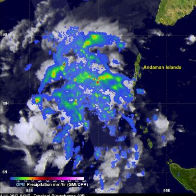
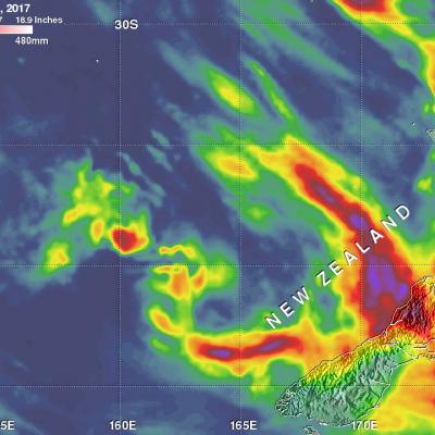
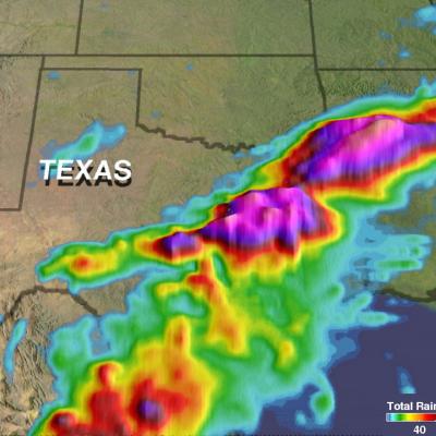
Extreme U.S. Rainfall Analyzed With IMERG Data

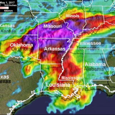
Tornadoes have accompanied severe weather over the United States almost daily during the past week. Severe storms spawned tornadoes from Texas and Oklahoma eastward through Mississippi. Upper Midwest states such Illinois, Indiana and Kentucky were also visited by tornadoes. Extreme rainfall caused deadly flooding in Missouri. More than a dozen people in the Midwest and South have been reported killed by tornadoes or flooding. The same weather system is spreading severe storms through East and Northeastern states today. NASA's Integrated Multi-satelliE Retrievals for GPM (IMERG) data were used

Intensifying Tropical Cyclone Francis Inspected By GPM

Tropical cyclone Francis formed north of Melville Island, Australia on April 27, 2017. Francis has been gradually intensifying while moving south-southwestward through the Timor Sea. Francis had maximum sustained winds estimated at 50 kts (57.5 mph) when the GPM core Observatory flew over on April 27, 2017 at 1936 UTC. The rainfall analysis shown here used data collected by GPM's Microwave Imager (GMI) and Dual-Frequency Precipitation Radar (DPR) instruments. DPR data indicated that strong convective storms near the center of the tropical storm were dropping rain at a rate of over 70 mm (2.8

Tropical Depression 03W In The Pacific Examined By GPM

Tropical Depression 03W formed in the Pacific Ocean west of Guam on April 24, 2017. The GPM core observatory satellite had an excellent view of TD03W when it flew over on April 14, 2017 at 1901 UTC. The GPM satellite found that the newly formed tropical depression contained some very powerful convective storms. Intense storms in the middle of the organizing convective cluster were dropping precipitation at extreme rates. GPM's Microwave Imager (GMI) and Dual-Frequency Precipitation Radar (DPR) instruments unveiled tall convective storm towers on the eastern side of this cluster of storms that

GPM Sees the Formation of Early Atlantic Ocean Tropical Depression 1

A low pressure area in the Atlantic Ocean, located southwest of the Azores was designated as Subtropical Depression One on April 19 as NASA examined its rainfall. By April 20 it had become the Atlantic's first tropical depression. Just as the subtropical depression was forming in the North Atlantic Ocean on April 19 at 11 a.m. EDT (1500 UTC) the Global Precipitation Measurement Mission or GPM core observatory satellite flew directly over it and identified areas where rainfall was heaviest in the system. Data collected by GPM's Microwave Imager (GMI) and Dual-Frequency Precipitation Radar (DPR)

GPM Sees Tropical Cyclone Maarutha Develop

Tropical Storm Maarutha became the first tropical cyclone of 2017 in the Bay of Bengal when it formed on April 15, 2017. Maarutha intensified slightly as it moved northeastward toward Burma (Myanmar). Maarutha reached it's maximum sustained wind speed of 45 kts (52 mph) over the open waters of the Bay Of Bengal. The GPM core observatory satellite had a good view of the forming tropical cyclone on April 14, 2017 at 0121 UTC when it was in the Bay Of Bengal west of the Andaman Islands. GPM had another excellent view just before the organizing tropical cyclone was designated tropical storm

New Zealand's Extreme Rainfall Examined With IMERG

Two extra-tropical cyclones recently dropped very heavy rain over New Zealand. Tropical cyclone Debbie dumped extreme amounts of rain over the northeastern coast of Australia when it hit the Queensland coast on March 28, 2017. After drenching northeastern Australia Extra-tropical Cyclone Debbie transported a river of water over New Zealand last week. Debbie's remnants dropped heavy rainfall that caused widespread flooding near the Bay of Plenty on New Zealand's northeastern coast. Thousands of residents needed to be evacuated with extra-tropical cyclone Debbie. This week extra-tropical cyclone

Texas' Heavy Rain Measured By IMERG

Over the past few days a slow moving frontal system moving through the Southwest produced heavy rain resulting in flooding and mudslides over central Texas. One person was reported swept away by flood water near Fort Hood Texas. NASA's Integrated Multi-satellitE Retrievals for GPM (IMERG) data were used to provide an estimate of rainfall accumulation over Texas. From April 10-12, 2017 IMERG estimates indicate that over 8 inches (203 mm) of rain fell in the area from central Texas through northern Louisiana.

GPM Observes Tropical Cyclone Forming North of Australia

The GPM Core Observatory satellite flew directly above a forming tropical cyclone in the Timor Sea northeast of Darwin, Australia on April 10, 2017 at 1146 UTC. Data collected by GPM's Microwave Imager (GMI) and Dual-Frequency Precipitation Radar (DPR) instruments showed that convective storms within the tropical low contained very heavy rainfall. GPM's DPR (Ku Band) data revealed that a line of intense storms west of the Bathurst and Melville islands was dropping rain at a rate of over 161 mm (6.3 inches) per hour. A 3-D examination of the forming tropical cyclone's cloud tops showed that

Deadly Flooding Rains Near Mocoa, Colombia Measured By IMERG

Late Friday night and Saturday morning flash flooding and mudslides killed over 250 people in Mocoa, Colombia. Extremely intense storms added heavy rain to water logged terrain around Mocoa. Water from this heavy rainfall converged into a river that runs close to Mocoa causing it to overflow it's banks with deadly results. Integrated Multi-satellitE Retrievals (IMERG) data were used to estimate the amount of rain that fell near Mocoa, Colombia during the seven day period from March 26 to April 2, 2017. IMERG indicates that area rainfall totals during the week were frequently greater than 80 mm

Tropical Cyclone Caleb's Rainfall Revealed By GPM

Tropical cyclone Caleb formed today in the South Indian Ocean southwest of the Indonesian Island of Sumatra. The GPM core observatory satellite had a fairly good view of the the newly formed tropical cyclone when it flew over on March 23, 2017 at 0756 UTC. The satellite's Microwave Imager (GMI) revealed the locations of rainfall within the tropical cyclone. Rainfall measurements derived from the GMI showed that convective storms's were dropping rain at a rate of almost 84 mm (3.3 inches) per hour on Caleb's eastern side. The Joint Typhoon Warning Center (JTWC) predicts that tropical cyclone