Images and caption by Hal Pierce (SSAI/NASA GSFC)

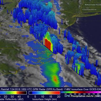
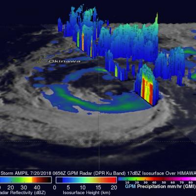
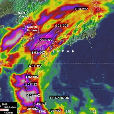
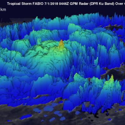
Subtropical Depression Five Observed By GPM

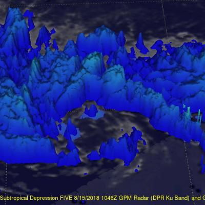
Subtropical Depression FIVE formed in the central Atlantic Ocean early today. The National Hurricane Center (NHC) classified it as subtropical. It is moving over warm ocean waters and has low vertical wind shear aloft so the system is predicted to slightly intensify. The GPM core observatory satellite passed above the western side of newly formed Subtropical Depression FIVE on August 15, 2018 at 1046 UTC. The GPM's Microwave Imager (GMI) and Dual-Frequency Precipitation Radar (DPR) instruments revealed that most of the rainfall within the subtropical depression was outside the middle of the

NASA's IMERG Estimates Of Rainfall Over The Eastern United States

Most of the Eastern half of the United States had rainfall during the past week. Some parts of the country experienced heavy rainfall that resulted in flash floods and various other problems. Slow-moving storm systems and nearly stationary fronts were the cause of heavy rainfall over Virginia this past weekend. Several trees were brought down by a severe storm that hit Fredericksburg, Virginia Sunday Afternoon. Fallen trees blocked several roads, flash flooding occurred and electrical power was lost in that area. Continuing heavy rain also fell in Texas over the weekend. This provided some

GPM Passes Over Weakening Hurricane John

The GPM core observatory satellite provided very good coverage of hurricane JOHN when it passed above the eye of the tropical cyclone on August 8, 2018 at 0:59 AM MDT (0659 UTC). JOHN's maximum sustained wind speeds had started to decrease. GPM's Microwave Imager (GMI) and Dual-Frequency Precipitation Radar (DPR) instruments showed that most of JOHN's precipitation was then located in the eastern half of the hurricane. A large cloud free area had developed between the center of the hurricane and an intense feeder band wrapping around the northern and western side of the hurricane. GPM's radar

GPM Views Tropical Storm John

The GPM core observatory satellite had an extremely good view of tropical storm John on August 6, 2017 at 1:08 AM MDT (0708 UTC). The satellite passed right over John's center of circulation. GPM's Microwave Imager (GMI) and Dual-Frequency Precipitation Radar (DPR) instruments provided excellent coverage of precipitation associated with tropical storm John. GPM showed that the large tropical cyclone was becoming well organized and had intense rainfall within feeder bands that were spiraling toward John's center. GPM's radar (DPR Ku Band) revealed that a band of powerful storms northeast of

GPM Sees Tropical Storm Hector Forming

Tropical storm Hector was forming in the eastern Pacific Ocean southwest of Mexico when the GPM core observatory satellite passed over on July 31, 2018 at 1:40 PM PDT (2040 UTC). Hector's maximum sustained winds at that time were estimated to be about 30 kts (34.5 mph). Powerful convective storms were wrapping around the western side of the deepening tropical low's center of circulation. GPM's Dual-Frequency Precipitation Radar (DPR) instrument collected data showing that rain in some of these storms was falling at a rate of almost 198 mm (7.8 inches) per hour. The GPM satellite's radar data

Flooding Rainfall Over the U.S. East Coast Examined by GPM

Flood watches and warnings have been issued today for states from North Carolina through New York. Major flooding of rivers and streams is forecast in Pennsylvania as heavy rainfall continues. A Large blocking high located east of Nova Scotia and Low Pressure over the upper mid west has been funneling moisture over the Mid-Atlantic states. This weather pattern includes a strong upper level trough with it’s axis becoming oriented from the Great Lakes through the eastern Gulf Of Mexico. This resulted in a dip in the jet stream that has been transporting tremendous amounts of moisture from the

Tropical Storm Ampil's Rainfall Evaluated With GPM Satellite Data

Tropical storm AMPIL was moving toward the northwest with winds of about 50 kts (57.5 mph) when the GPM core observatory satellite flew above on July 20, 2018 at 0656 UTC. Data received by the satellite's Microwave Imager (GMI) and Dual-Frequency Precipitation Radar (DPR) instruments were used in this analysis of AMPIL's precipitation. GMI and DPR showed that the northern side of the tropical storm was nearly dry and that rain bands in that area were producing only light to moderate rainfall. Moderate to heavy precipitation was found by GPM in a rain band wrapping around the southern side of

GPM IMERG Analyzes Rainfall from Powerful Typhoon Prapiroon

The image above shows estimates of accumulated rainfall using IMERG (Integrated Multi-satellitE Retrievals for GPM) data formed during the period from June 28-July 6, 2018. Typhoon PRAPIROON developed in the northwest pacific Ocean east-northeast of the Philippines on June 28, 2018. PRAPIROON became a typhoon on July 2nd as it approached the Korea Strait between Japan and Korea. Stormy weather had already produced heavy rainfall in Korea and Japan before typhoon PRAPIROON moved through the area. IMERG estimates indicated that PRAPIROON and other stormy weather dumped over 512 mm (20.2 inches)

Eastern Pacific Tropical Storm Fabio Examined With GPM Satellite

NASA's GPM core observatory satellite flew above tropical storm FABIO in the eastern Pacific Ocean south of Mexico on June 30, 2018 at 10:46 PM MDT (July 1, 2018 at 0446 UTC). FABIO has continued to intensify since then and the National Hurricane Center (NHC) predicts that the tropical storm will become a hurricane later today. FABIO is then expected to become a major hurricane on July 3, 2018 and reach it's peak intensity with wind speeds of about 105 kts (121 mph). Rainfall measurements by GPM's Microwave Imager (GMI) and Dual-Frequency Precipitation Radar (DPR) instruments showed that FABIO