Images and caption by Hal Pierce (SSAI/NASA GSFC)

Tropical Storm Prapiroon Probed By GPM Core Observatory Satellite

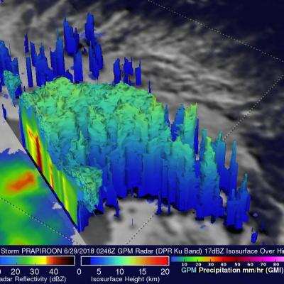
Tropical depression 09W was located in the northwest Pacific east of the Philippines when it was upgraded today to tropical storm PRAPIROON. The tropical storm is in a favorable environment for intensification. Vertical wind shear is low above the tropical cyclone and sea surface temperatures are warm below. NASA's GPM core observatory satellite had a good view of tropical storm PRAPIROON on June 29, 2018 at 0246 UTC. PRAPIROON was just barely a tropical storm with maximum sustained wind speeds estimated at about 35 kts (40.3 mph). GPM's Microwave Imager (GMI) and Dual-Frequency Precipitation

Oklahoma Mesoscale Convective System (MCS) Examined With GPM

The GPM Core observatory satellite's passed over Oklahoma on Monday, June 25, 2018 04:08 AM CDT (0508 UTC). The satellite makes measurements of precipitation with it's GPM's Microwave Imager (GMI) and Dual-Frequency Precipitation Radar (DPR) instruments every 95 minutes as it orbits the earth at 252.3 miles (407 km). The area covered by GPM's radar is shown in lighter shades. GPM passed directly over the center of a Mesoscale Convective System (MCS) that was moving across Oklahoma. GPM found that the MCS contained some intense storms. GPM's DPR can make accurate rainfall measurements along it

Southern Texas' Flooding Rainfall Examined With IMERG

Extremely heavy rainfall caused a flash flood emergency over southern Texas this week. More than 15 inches (381 mm) of rain fell in Hidalgo County, Texas since Tuesday June 19, 2018. The Governor of Texas declared a state of emergency for six counties in South Texas Thursday afternoon. Heavy rain had ended Friday morning but occasional showers were still occurring over southern Texas. At 4:28 AM CDT Friday June 22, 2018 the National Weather Service in Brownsville, Texas issued a "Flood Warning for Urban Areas and Small Streams in... Southwestern Hidalgo County in Deep South Texas..."

GPM Satellite Probes Storms In The Western Gulf Of Mexico

A mid-level and surface trough over southern Texas is producing heavy rainfall. Heavy rainfall is expected to continue in the area through Wednesday evening. On June 19, 2018 at 3:37 PM CDT ( 2037 UTC) the GPM core observatory satellite passed over the western Gulf Of Mexico. This GPM pass revealed extreme rainfall that was being produced by a tropical disturbance in the northwestern Gulf Of Mexico. GPM's Microwave Imager (GMI) and Dual Frequency Precipitation Radar (DPR) instruments probed powerful storms that were dropping rain at a rate of 3.5 inches (88 mm) per hour. The GPM satellite's

Hurricane Bud's Rainfall Measured with GPM IMERG

Beneficial rainfall from hurricane Bud's remnants has spread into the Desert Southwest. This rainfall may be helpful in an area that has been experiencing exceptional drought accompanied by wildfires. Bud's rainfall may also signal the beginning of the summer monsoon over the Desert Southwest. The image above shows estimates of accumulated rainfall using IMERG (Integrated Multi-satellitE Retrievals for GPM) data generated during the period from June 9-18, 2018. This rainfall occurred during the period when Bud formed southwest of Mexico, intensified into a powerful category four hurricane

GPM Probes Tropical Storm Maliksi

The GPM core observatory satellite had an excellent view of tropical storm MALIKSI when it passed over southern Japan on June 10, 2018 at 1759 UTC. GPM's Microwave Imager (GMI) and Dual Frequency Precipitation Radar (DPR) instruments collected data that revealed the horizontal and vertical extent of precipitation within the tropical storm. GPM's GMI showed that heavy downpours were occurring in a rain band wrapping around MALIKSI's northeastern side. GPM's radar (DPR Ku Band) found that bands of storms moving around the northwestern side of the tropical storm were dropping rain at a rate of

GPM Flies Over Intensifying Hurricane Aletta

As expected, tropical storm Aletta intensified and became a hurricane. Aletta was a powerful hurricane with winds of about 85 kts (98 mph) when the GPM core observatory satellite passed over head on June 7, 2018 at 18:38 PM MDT (June 8, 2018 at 0038 UTC). GPM's Microwave Imager (GMI) and Dual Frequency Precipitation Radar (DPR) instruments showed that hurricane Aletta contained powerful storms that were producing heavy precipitation. Very strong convective storms were producing heavy rainfall in Aletta's eye wall while the most extreme downpours were shown in a large feeder band wrapping

Tropical Storm Aletta Forms In Eastern Pacific

Early today Tropical Depression Two-E was upgraded to tropical storm Aletta. This is the first tropical storm of the 2018 eastern North Pacific season. Aletta was located well southwest of Mexico. The National Hurricane Center (NHC) predicts that Aletta will become a hurricane tomorrow as it moves westward over the open waters of the eastern North Pacific ocean. The GPM core observatory satellite passed above developing tropical storm Aletta on June 6, 2018 at 0046 UTC. This image shows precipitation measurements that were calculated from data collected by GPM's Microwave Imager (GMI) and Dual

GPM Examines Forming Subtropical Storm Alberto

At 10:00 AM CDT today the National Hurricane Center (NHC) upgraded low pressure center (90L) to Subtropical Storm Alberto. Alberto moved over the waters of the northwestern Caribbean Sea. Alberto is expected to bring heavy rainfall and flash flooding to the northeastern Yucatan, western Cuba and Florida over the Memorial Day weekend. The GPM core observatory satellite passed above the Yucatan Peninsula on May 24, 2018 a 11:19 PM EDT (May 25, 2018 at 0319 UTC). With this pass GPM saw areas of heavy precipitation within the western Caribbean and in the Gulf Of Mexico west of Cuba. GPM's Dual

Tropical Cyclone Mekunu Examined With GPM Satellite

The second tropical cyclone in less than a week has formed in the western Arabian Sea early on May 22, 2018. This tropical cyclone called MEKUNU is intensifying as it heads toward Oman. The Joint Typhoon Warning Center (JTWC) predicts that MEKUNU will have winds of about 85 kts (98 mph) when it hits southwestern Oman in about three days. This will make it the equivalent of a category two hurricane on the Saffir-Simpson hurricane wind scale. Tropical cyclone MEKUNU follows on the heels of destructive and deadly tropical cyclone SAGAR that just made landfall over northwestern Somalia a few days