Images and caption by Hal Pierce (SSAI/NASA GSFC)

Heavy Rainfall Across the U.S. Measured from Space

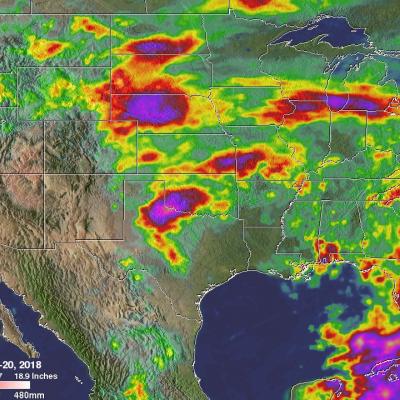
For close to two weeks the combination of a nearly stationary front and tropical moisture caused almost continuous precipitation over much of the Mid-Atlantic. Record amounts of rain fell over the eastern United States with over a foot of rain reported in some parts of the Mid-Atlantic. The excessive rain led to flooding along several rivers including the Potomac river. This image shows anomalous rainfall for the period from May 11-20, 2018. This analysis used climatology data that were based on measurements by the Tropical Rainfall Measuring Mission (TRMM) satellite from 1997- 2015. The TRMM

Tasmania's Flooding Rainfall Measured With NASA's IMERG

Last week Tasmanian's were evacuated, businesses were flooded and cars washed away as extreme rainfall accompanied a strong cold front and a low pressure system that spawned violent storms. Hobart city, located in southeastern Tasmania, received record breaking rainfall of more than 100 mm (3.93 inches) in a single day. A strong pressure gradient developed between the complex low pressure center over Tasmania and high pressure that was moving eastward over the Great Australian Bight (Southern Ocean). This strong pressure gradient resulted in destructively high south-easterly winds over

Potential Eastern Pacific Tropical Cyclone Viewed By GPM

The Eastern Pacific hurricane season officially starts on May 15, 2018. A low pressure center located well to the southwest of the Baja California Peninsula may develop into this area's first tropical cyclone of 2018. Low vertical wind shear and warm ocean temperatures in the vicinity of the low are providing favorable conditions for this low's development into a tropical cyclone. If it develops it will be called Aletta. The GPM core observatory satellite passed over the center of the most intense convective storms in this potential tropical cyclone. Rainfall data collected by GPM's satellite

NASA's IMERG Shows Devastating Rainfall Over East Africa

Heavy seasonal rainfall has recently caused flooding in Kenya resulting in displacement of over 244,000. This deluge follows the severe drought that afflicted East Africa in 2017. The estimated death toll from flooding and mudslides has recently been increased to about 100 people. Rainfall accumulation estimates from NASA's Integrated Multi-satellitE Retrievals for GPM (IMERG) data are shown here for the period from April 27 to early May 4, 2018. During this period heavy seasonal precipitation fell over Kenya. Rainfall totals in some areas near the Indian Ocean coast were estimated by IMERG to

Developing Severe Weather in the U.S. Midwest Examined By GPM

Until yesterday tornado alley was experiencing a drought of spring tornadoes. The eighteen tornadoes reported in the area yesterday may be a sign of things to come. Moisture laden air from the Gulf Of Mexico is having a more normal interaction with dry air flowing from the desert south-western states (dry line). Wind speed and wind direction change (shear) with height results in thunderstorms that spawn rotation and tornadoes. The GPM core observatory satellite passed over tornado alley in the early morning of May 1, 2018 at 6:28 AM CDT (11:38 UTC). Tornadoes were not observed until the

GPM Satellite Views Tropical Cyclone Flamboyan's Rainfall

Tropical cyclone FLAMBOYAN formed in the middle of the South Indian Ocean well to the west of Australia on April 28, 2018. Today FLAMBOYAN's wind speeds have increased to about 70 kts (81 mph) as the tropical cyclone curved toward the south-southwest around the subtropical ridge. The Joint Typhoon Warning center (JTWC) predicts that FLAMBOYAN will start weakening soon as it moves even farther to the south and encounters increasing vertical wind shear and colder ocean temperatures. The GPM core observatory satellite had a good view of the rainfall in tropical cyclone FLAMBOYAN when it flew over

GPM Satellite Sees Storms Over Israel

An upper level low generated stormy weather for a few days as it moved through the southeastern Mediterranean. Heavy rainfall in these storms resulted in deadly flash floods that killed ten teenagers in southern Israel. The GPM core observatory satellite passed above intense storms that were moving through the eastern Mediterranean on April 25, 2018 at 1409 UTC (4:09 PM IST). Data collected by the satellite's Microwave Imager (GMI) and Dual Frequency Precipitation Radar (DPR) instruments revealed the location of heavy rainfall that was approaching Israel. GPM's radar (DPR Ku Band) measured

GPM Sees Tropical Cyclone Fakir Forming Near Madagascar

The southwest Indian Ocean cyclone season started on November 15, 2017 and will officially end on April 30, 2018. A tropical cyclone labeled FAKIR by Meteo France formed today near northeastern Madagascar. FAKIR is expected to intensify as it moves toward the southeast and could be a significant tropical cyclone tomorrow. This cyclone season has already seen Madagascar battered and drenched by tropical cyclones Ava, Dumazile, and Eliakim. The GPM core observatory satellite flew above the forming late season tropical cyclone near northeastern Madagascar on April 22, 2018. The satellite's

GPM Data Used to Evaluate Hawaii's Flooding Rainfall

A low pressure trough moving slowly westward through the northwestern Hawaiian Islands caused destructive flooding and mudslides over the past weekend. The trough disrupted the normal northeast trade winds flow north of Oahu on April 12, 2018. This caused extremely heavy rainfall as the trough deepened and moved very slowly over Kauai during the weekend. The 28.1 inches (713 mm) of rain reported in Hanalei within a 24 hour period was close to a record for the small town on Kauai's northern coast. Almost 32.4 inches (822 mm) of rain was reported during the same period over Wainiha, Kauai

GPM Catches Line of Strong Storms Responsible For Tornadoes in Eastern U.S.

Yesterday, Sunday April 15th, a line of strong storms at one point stretched from the Florida Straits below the Florida Keys all the way up the East Coast and into Ohio. Many of the storms were strong with wide spread reports of wind damage from north Florida up through the Carolinas and into central Virginia. Among these were several reports of tornadoes from Florida to Virginia. The most significant were an EF-2 tornado that stuck Greensboro, NC, killing one person, and a tornado near Lynchburg in Amherst County Virginia that injured 8 people. GPM captured this image of the advancing line of