Images and caption by Hal Pierce (SSAI/NASA GSFC)

GPM Sees Walaka Becoming A Powerful Hurricane

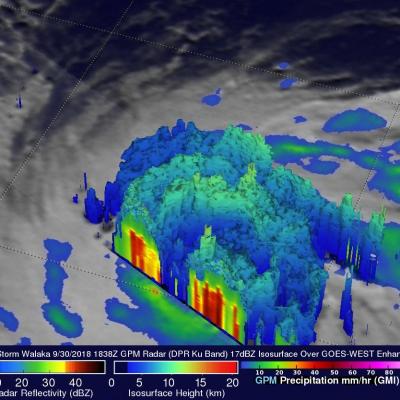
The GPM core observatory recently had a couple good looks at tropical storm Walaka as it was intensifying into a powerful hurricane. GPM passed directly over tropical storm Walaka when it was located south of the Hawaiian islands on September 30, 2018 at 8:38 AM HST (1838 UTC). Data collected by GPM's Microwave Imager (GMI) and Dual-Frequency Precipitation Radar (DPR) instruments showed that Walaka was well organized and very close to hurricane intensity. GPM's Radar (DPR Ku Band) data revealed intense convective storms in a large feeder band that was wrapping around the tropical storm's

Super Typhoon Trami's Rainfall Examined By GPM

The GPM core observatory satellite probed super typhoon TRAMI when it traveled above the northwestern Pacific Ocean on September 24, 2018 at 1203 UTC. At that time TRAMI had maximum sustained winds estimated at 130 kts (150 mph). This image shows rainfall measurements that were made using data collected by GPM's Microwave Imager (GMI) and Dual-Frequency Precipitation Radar (DPR) instruments. GPM's GMI showed the locations of extremely heavy rainfall in the super typhoon's well defined circular eye. GPM's radar (DPR Ku Band) coverage was limited because it's swath only included storms on the

GPM Probes Tropical Storm Isaac

Hurricane Florence, tropical storm ISAAC and hurricane Helene are currently active in the Atlantic Ocean. Tropical storm ISAAC is the next tropical cyclone to affect the western Atlantic. It is moving westward toward the Leeward and Windward Islands. The National Hurricane Center (NHC) predicts that ISAAC will pass through the Leeward and Windward Islands and move into the Caribbean Sea over the next few days. The NHC predicts that ISAAC will weaken as it encounters moderate vertical shear and nearby dry air. The GPM core observatory satellite had an excellent view of tropical storm ISAAC on

GPM Views Super Typhoon Mangkhut Moving Towards the Coast of China

View Fullscreen in STORM Event Viewer A day after rolling through the southern Mariana Islands, causing wind and water damage to Guam and other nearby islands, Mangkhut has intensified into a Category 4 Super Typhoon with winds of 135 knots. With favorable conditions and the warm waters of the Philippine Sea, it is expected to maintain much of this intensity as it continues to track west-northwestward. Currently models anticipate Mangkhut to pass between the Phillipines and Taiwan, weakening slightly due to interaction with the two islands, before continuing toward the Southeastern Chinese

GPM Sees Hurricane Florence Swirling In The Central Atlantic

Hurricane FLORENCE became more powerful over the past few days while moving through the central Atlantic Ocean. Wind speeds increased from tropical storm force to hurricane force on Tuesday. FLORENCE's maximum sustained winds were about 85 kts (98 mph) early today making it a category two hurricane on the Saffir-Simpson Hurricane wind scale. Hurricane FLORENCE is being steered toward the northwest by the Atlantic subtropical ridge. Early next week the National Hurricane Center (NHC) predicts that hurricane FLORENCE will have moved to a location southeast of Bermuda. The GPM core observatory

GPM Sees Tropical Cyclone Jebi Threaten Japan

Japan has been afflicted by several tropical cyclones and other extreme weather this summer. The Joint Typhoon Warning Center (JTWC) predicts that yet another typhoon called JEBI will be approaching the main islands of Japan early next week. Warm ocean temperatures and low vertical wind shear are providing a favorable environment for JEBI's intensification. The JTWC predicts that the typhoon will have peak sustained winds of 115 kts (132 mph) as it moves over the northern Pacific Ocean toward Japan next week. The GPM core observatory satellite passed above on August 28, 2018 at 1816 UTC when

Tropical Storm Miriam's Formation Observed by GPM

Tropical cyclone's continue to regularly develop in the eastern Pacific Ocean. Tropical Depression Fifteen-E formed in the eastern Pacific Ocean about 1000 nautical miles (1852 km) southwest of the Baja California peninsula early on Sunday August 26, 2018. TD15E became better organized with increased banding later in the day and was upgraded by the National Hurricane Center (NHC) to tropical storm MIRIAM. The GPM core observatory satellite saw the forming tropical storm earlier on August 26, 2018 at 0223 UTC. Heavy rainfall near the center of the forming tropical cyclone was examined with the

GPM Sees Hurricane Lane Threatening Hawaiian Islands With Heavy Rainfall

The GPM core observatory satellite flew over hurricane LANE on August 21, 2018 at 7:48 PM PST (August 22, 2018 at 0548 UTC). At that time LANE was located about 316 nautical miles (585.2 km) from Hilo, Hawaii. Hurricane LANE is one of the strongest tropical cyclones to move into the Hawaiian Islands. At the time of this GPM pass LANE was a category five on the Saffir-Simpson hurricane wind scale with winds of about 140 kts (161 mph). This analysis shows precipitation derived from data collected by the GPM satellite's Microwave Imager (GMI) and Dual-Frequency Precipitation Radar (DPR)

Powerful Hurricane Lane Probed By GPM Satellite

Hurricane LANE had moved westward into the central Pacific Ocean far southeast of the Hawaiian islands when the GPM core observatory satellite passed above on August 19, 2018 at 1643 UTC. LANE had intensified and had maximum sustained winds reaching about 105 kts (~ 121 mph) at that time. This made it a category three on the Saffir-Simpson hurricane wind scale. The GPM satellite's Microwave Imager (GMI) and Dual-Frequency Precipitation Radar (DPR) instruments provided highly accurate information about precipitation within the hurricane. GPM's GMI revealed rainfall coverage and GPM's radar (DPR

Intensifying Hurricane Lane Examined by GPM Satellite

View fullscreen in STORM Event Viewer Heavy rainfall and towering cloud heights were the findings when Hurricane Lane was scanned by the Global Precipitation Measurement mission or GPM core observatory satellite on Aug. 17. Lane strengthened to a Category 2 hurricane on the Saffir-Simpson Hurricane Wind Scale. GPM passed above Lane in the Eastern Pacific Ocean on Aug. 17, 2018, at 1:26 a.m. EDT (0526 UTC). Lane was intensifying and data collected by GPM's Microwave Imager (GMI) and Dual-Frequency Precipitation Radar (DPR) instruments revealed the location of its forming eye wall. Very heavy