Images and caption by Hal Pierce (SSAI/NASA GSFC)

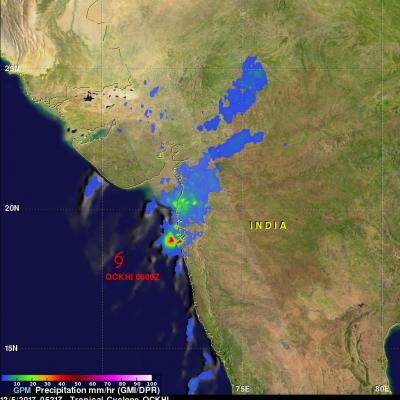
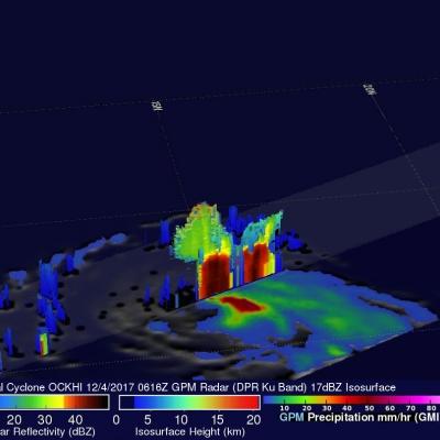
Tropical Cyclone Ava Viewed By GPM

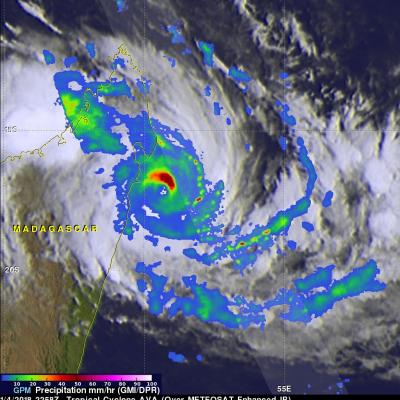
Tropical cyclone AVA formed in the southeast Indian Ocean northeast of Madagascar on January 2, 2018. AVA became increasingly powerful and approached the eastern coast of Madagascar with maximum sustained winds estimated to be greater than 90 kts (103.5 mph). AVA has been interacting with land and wind speeds near Tamatave, Madagascar have been reported to be 70 kts (80.5 mph). The Joint Typhoon Warning Center (JTWC) predicts that tropical cyclone AVA will move to the south along Madagascar's eastern coast for a day or so and then return to the Indian Ocean. Very heavy rainfall is expected to

GPM Finds Heavy Rain In Short Lived Tropical Cyclone Hilda

Tropical cyclone HILDA formed very close to Australia's northwestern coast on December 27, 2017 at 1800 UTC and dissipated quickly as it crossed over land. The GPM core observatory satellite had a good view of the short lived tropical cyclone on December 27, 2017 at 2031 UTC. A red tropical storm symbol shows HILDA's approximate location when GPM passed above. The center of GPM's coverage was mainly east of HILDA's center of circulation. The intensity of rainfall in a large intense band of storms wrapping around the northeastern side of the tropical cyclone was measured by the satellite's

GPM Views Potential Australian Tropical Cyclone

On December 26, 2017 at 0806 UTC The GPM core observatory satellite satellite flew above northwestern Australia. GPM traveled over an area of convective thunderstorms in the Indian Ocean north of Australia's coast where a tropical cyclone is expected to develop. GPM's Microwave Imager (GMI) and Dual-Frequency Precipitation Radar (DPR) instruments collected data that showed heavy precipitation in storms off the Australian coast. GPM's radar (DPR Ku Band) showed that a few extremely powerful convective storms northwest of the Dampier Land coast were dropping precipitation at a rate of greater

Tropical Storm Tembin Rainfall Added To IMERG Analysis

Tropical storm Tembin moved over the Philippine island of Mindanao on Friday December 22, 2017. Tembin added to the death and destruction already caused by tropical storm Kai-Tak that hit the central Philippines less than a week ago. Tembin brought heavy rainfall that resulted in more deadly flooding and landslides. At least eight deaths in the Philippines have been blamed on tropical storm Tembin. Rainfall totals in this accumulation analysis were updated to include IMERG data from both tropical storms Kai-Tak and Tembin. This rainfall analysis shows rainfall accumulation estimates from IMERG

Deadly Tropical Storm Kai-tak Examined With IMERG And GPM Satellite

Tropical storm KAI-TAK was nearly stationary at times as it drenched the Philippines during the past five days. The storm caused major flooding and landslides. Many homes, roads and bridges were reported destroyed by landslides. Over 30 deaths were caused by the slow-moving tropical storm. A rainfall accumulation analysis of tropical cyclone KAI-TAK was derived from NASA's Integrated Multi-satellitE Retrievals data (IMERG) for the period from December 13-18, 2017. Tropical cylone KAI-TAK's approximate locations and positions are shown overlaid in white on this analysis. IMERG data were used to

GPM Sees Ockhi's Rain Reaching India's Western Coast

NASA's GPM Core Observatory satellite passed over western India on December 5, 2017 at 0521 UTC. GPM's Microwave Imager (GMI) and Dual-Frequency Precipitation Radar (DPR) instruments showed precipitation from dissipating tropical cyclone OCKHI reaching India's western coast. GPM's radar (DPR Ku band) indicated that rain was falling at a rate of over 101.6 mm (4 inches) per hour in a few storms near India's coast. OCKHI's low level center of circulation, shown with a red tropical cyclone symbol, was located well to the southwest of the storms that were moving onto India's western coast. This 3

Tropical Cyclone Ockhi's Rainfall Examined By GPM

On December 2, 1027 OCKHI became the first tropical cyclone of the year to form in the Arabian Sea. Fortunately for India the tropical cyclone remained off India's southwestern coast. OCKHI intensified to the equivalent of a category 3 hurricane on the Saffir-Simpson hurricane wind scale before it started to weaken. Vertical wind shear caused OCKHI to weaken as the tropical cyclone started moving north-northeastward toward India's Gulf of Khambhat. NASA's GPM Core Observatory satellite passed over tropical cyclone OCKHI on December 4, 2017 at 0616 UTC. The rainfall coverage shown here was

GPM Observes Tropical Cyclone Dahlia In Southwest Indian Ocean

Yesterday tropical Cyclone Dahlia became the first tropical cyclone of the 2017-2018 Southwest Indian Ocean season. Today, Dahlia was moving toward the southeast and was passing to the south of the Indonesian islands of Java and Sumatra with wind speeds of about 35 kts (40.3 mph). Tropical cyclone Dahlia was passing over the warm ocean waters (28-29 degrees Celsius) of the Indian Ocean. On November 29, 2017 at 1731 UTC NASA's GPM Core Observatory satellite passed above forming tropical cyclone Dahlia. Data collected by GPM's Microwave Imager (GMI) and Dual-Frequency Precipitation Radar (DPR)

GPM Views Severe Rain Storms Over Western Saudi Arabia

Intense rain storms have moved into Jeddah, Saudi Arabia today. Heavy downpours caused schools and universities to close. The General Authority of Meteorology and Environment Protection predicts that Heavy rain will continue for a couple days. NASA's GPM Core Observatory satellite measures precipitation from space with the first space-borne Ku/Ka-band Dual-frequency Precipitation Radar (DPR) and a multi-channel GPM Microwave Imager (GMI). The satellite passed over western Saudi Arabia on November 21, 2017 at 0123Z. GPM's Microwave Imager (GMI) and Dual-Frequency Precipitation Radar (DPR)

GPM Sees Remnants Of Tropical Storm Haikui Affecting Vietnam

The GPM core observatory satellite provided information about rainfall associated with the remnants of tropical storm Haikui on November 2017 at 0929 UTC. Earlier this month, typhoon Damrey caused widespread destruction when it hit Vienam on November 4, 2017. Fortunately tropical storm Haikui dissipated over the South China Sea before it reached Vietnam. Rainfall data collected by GPM's Microwave Imager (GMI) and Dual Frequency Precipitation Radar (DPR) instruments revealed that some storms with tropical storm Haikui's remnants contained light to moderate precipitation. A small cluster of