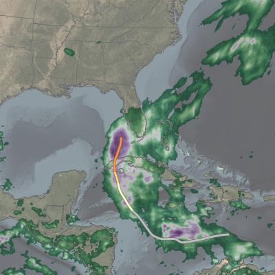
Applications

Photo of Odina Echeta
Overview: This project works to validate the GPM dual-frequency precipitation radar (DPR) merged scan product against a quality-controlled ground reference data (GV-MRMS) in the continental US. Knowledge from this concept study will be applied to validating/ evaluating and selecting remotely-sensed satellite rainfall products that could be useful for rainfall estimation in data-scarce regions such as West Africa. Mentors: Yagmur Derin , Pierre Kirstetter
Photo of Chuntao Liu
Affiliation: Texas A&M University – Corpus Christi, Corpus Christi, Texas, USA Project Mentees: Eva Yamamoto , June Choi ; Nimisha Wagle
Photo of Mircea Grecu
Affiliation: Goddard Earth Sciences Technology and Research, Morgan State University, and NASA Goddard Space Flight Center, USA Project Mentees: Charlene Gaba , Idelbert Behanzin
Photo of June Choi
Overview: Understanding how the behavior of large-scale precipitating systems is impacted by atmospheric variables can yield important insights about subseasonal variability and predictability across different regions. For this project, we explored the relationship between atmospheric variables and the characteristics of large precipitating systems, such as their size, geographic distribution, volume of rain, and maximum height of the system. Mentor: Chuntao Liu
Photo of Idelbert Behanzin
Overview: This project uses IMERG to characterize the spatial and temporal extreme precipitation events over West Africa. Mentor: Mircea Grecu
Photo of Simon Ageet
Overview: Hydrometeorological natural hazards are on the rise globally, yet in Africa, rainfall data which is crucial in mitigation efforts is lacking. Understanding the amount and distribution of rainfall and how it plays a role in causing these natural hazards is critical to improve disaster response and mitigation efforts. This project uses GPM IMERG data together with resources like NASA's Landslide Viewer to determine a precipitation threshold for landslides in the Mt. Elgon region of Uganda. Mentors: Vasco Mantas , Zhong Liu , Andrea Portier , Dorian Janney
Screenshot of the High-Impact Weather Assessment Toolkit (HIWAT),
Bangladesh has a long history of deadly and costly storms. Because these storms are so localized, they can be notoriously difficult to forecast, especially without access to the most advanced weather prediction technology. Researchers have created a new tool to boost the country’s ability to forecast severe weather. The SERVIR program - a joint initiative of NASA, USAID, and leading geospatial organizations in Asia, Africa, and Latin America - and the Bangladesh Meteorological Department ( BMD ) recently launched the High-Impact Weather Assessment Toolkit ( HIWAT ), a web-based tool that
IMERG totals from twin cyclones in the Indian Ocean
Over the past several days, a relatively rare event occurred in the eastern Indian Ocean: the formation of “twin” tropical cyclones. Tropical Cylones Karim and Asani formed at nearly the exact same time (06:00 UTC and 06:30 UTC, 12:00 pm and 12:30 pm local time) on May 7 on opposite sides of the Equator. Karim officially formed first in the southern hemisphere (SH) followed immediately by Asani in the northern hemisphere (NH). At first glance, the cyclones appear to be mirror images of one another with Asani rotating counterclockwise in the NH and Karim rotating clockwise in the SH roughly
IMERG rainfall totals in South Africa, April 5 - 18, 2022.
An upper-level area of low pressure tapped into the warm waters of the South Indian Ocean to bring heavy rains and flooding to parts of South Africa during the second week of April. The event unfolded when an upper-level trough of low pressure embedded within the midlatitude westerlies traversed the southern part of Africa from west to east. As the trough approached the east coast of South Africa, an area of low pressure became detached from the main flow, this “cut off” low then drifted over the warm waters of the Agulhas Current, which channels warmer waters from the tropical Indian Ocean
IMERG Rainfall Totals from Australian :"Rain Bomb" in March 2022
The below animation shows surface rainfall estimates from NASA’s IMERG multi-satellite precipitation product for the week starting on Feb. 22, 2022 at 0000 UTC and ending on Feb. 28, 2022 at 2330 UTC. Areas shaded in blue and yellow show three-hour average snapshots of IMERG rain rates every half-hour overlaid on cloudiness (shown in white/gray) based on geosynchronous satellite infrared observations. Below the rain rates and cloudiness data, IMERG rainfall accumulations are shown in green and purple. Tropical Cyclone Anika’s track is shown with a gray line based on data from the U.S. Navy-Air