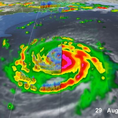
Applications

IMERG Precipitation Anomalies
Rain gauges are plentiful around the United States, but that’s not the case elsewhere in the world – particularly over oceans and sparsely populated areas. That means scientists and other data users have to rely on satellite measurements – such as those provided by NASA’s Global Precipitation Measurement (GPM) mission – to fill in the gaps. The list of data users now includes the U.S. Air Force’s 557th Weather Wing. For the first time, the Air Force meteorology unit has integrated the Integrated Multi-satellite Retrievals for GPM (IMERG) algorithm into its operational weather forecasts and
GPM overpass of tropical storm Nicole
Hurricane Nicole hit the East Coast of Florida early yesterday morning, November 10 th, 2022, at 3:00 am (EST) just south of Vero Beach at North Hutchinson Island. But, unlike Hurricane Ian which came ashore in late September as a powerful Category 4 storm that devasted parts of southwest Florida, Nicole made landfall as minimal Category 1 storm. Though far less intense, Nicole has still brought some heavy rain and gusty winds to the region. Nicole originated from a non-tropical low pressure system over the southwestern Atlantic. As a result, when the National Hurricane Center (NHC) was first
Screenshot of mentors and participants (mentees) during the last session of the 2022 Mentorship Program.
The GPM Applications Team in collaboration with the University of Coimbra created the GPM Mentorship Program to support new and existing user communities and provide tailored hands-on learning experiences in using GPM data for applications. The goal of the program is to provide an overview of using state-of-the-art satellite-based precipitation estimates, and to provide users their first experience of applying GPM data to support real-world problems. The 2022 initiative is the first edition of the mentorship program.
IMERG analysis of Hurricane Ian
On Sept. 30, 2022, Hurricane Ian was approaching South Carolina, which was one day after Ian finished its west-to-east crossing of Florida. NASA has been estimating Hurricane Ian's precipitation over land and ocean, which complements the array of detailed observations collected by NOAA and other agencies of Ian's impact over land.
GPM overpass of Hurricane Ian on Sept. 26, 2022
Hurricane Ian became one of the strongest hurricanes on record to strike Florida when it made landfall Wednesday, Sept. 28th, 2022, around 3:10 pm (EDT) as a Category 4 storm near Cayo Costa, FL, about 20 miles west-southwest of Punta Gorda on Florida’s southwest coast. This same area was hit hard by Hurricane Charley in 2004, which also made landfall as a strong Category 4 storm. Both storms passed over and were intensified by the deep, warm waters of the southeastern Gulf of Mexico. Ian originated from a tropical easterly wave that propagated westward off the coast of Africa across the
Photo of Joe Turk
Affiliation: NASA Jet Propulsion Laboratory, California Institute of Technology, USA Project Mentee: María Paula Hobouchian
Photo of Jackson Tan
Affiliation: University of Maryland Baltimore County and NASA Goddard Space Flight Center, Greenbelt, MD, USA Role: GPM Mentorship Session Facilitator
Photo of Courtney Schumacher
Affiliation: Texas A&M University, College Station, USA Project Mentees: Armand Kablan, Ayuna Santika
Photo of Andrea Portier
Affiliation: Science Systems and Applications, Inc. and NASA Goddard Space Flight Center, Greenbelt, MD, USA Project Mentees: Simon Ageet
Photo of Zhong Liu
Affiliation: NASA Goddard Earth Sciences (GES) Data and Information Services Center (DISC) and George Mason University, Greenbelt, Maryland Project Mentee: Simon Ageet