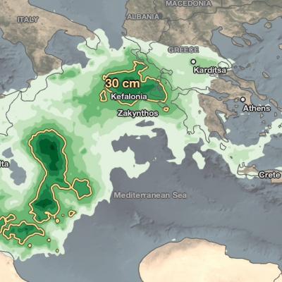
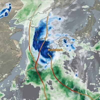
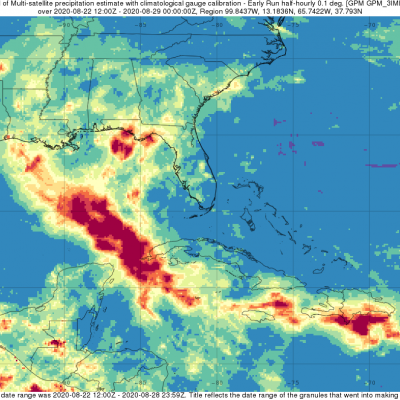
Logo for GPM Applications showing ecology, water and agriculture, energy, disasters, health, and weather.

Applications Articles

Field in Pakistan
Download this video from the NASA Goddard Scientific Visualization Studio Today, India is among the world’s most water-scarce countries. This means that it does not have enough freshwater resources to meet the needs of all the people who live there. Mismanagement of water resources have largely contributed to the country’s limited water supplies. A growing competition over finite water resources will have serious implications for Indian farmers, as well as India’s food security. More than 70% of India’s population rely on agriculture as a source of livelihood. Even more so, an estimated 82% of...
GPM Overpass of Cyclone Harold from April 6th, 2020
Video credit: Greg Shirah, Kel Elkins, Alex Kekesi (NASA Goddard Scientific Visualization Studio). For more information or to download this public domain video, go to: https://svs.gsfc.nasa.gov/4812#29226 A Category 4 cyclone, the most powerful yet of 2020, made landfall on the South Pacific nation of Vanuatu on Monday, not long before this GPM overpass from April 6th, 2020 at 1:41 UTC. Tropical Cyclone Harold developed from a low pressure system that was observed to the east of Papua New Guinea last week, and has tracked to the southeast, where it has already caused flooding and loss of life...
IMERG rainfall totals from Australia in November 2019
Droughts and dry, arid conditions are naturally occurring phenomena in Australia. Such an environment is conducive to wild fires, which are started mainly by lightning and can occur throughout the year, but typically emerge between October and April and are most prevalent during the Southern Hemisphere summer; they are part of the seasonal cycle in Australia. However, some years are worse than others, and the 2019-2020 wild fire season was especially bad. It has been estimated that upwards of 46 million acres were burned, or roughly the size of the entire state of Washington. In terms of area...
Extratropical Storm Dennis, February 15, 2020
Storm Dennis is an extratropical cyclone that developed over the continental United States before undergoing explosive intensification as it crossed into the North Atlantic. On February 15 shortly after this GPM overpass, Dennis reached its minimum central pressure of 920 mb, which is reported to be the second-lowest on record for a North Atlantic winter storm. The eye can be seen south of Iceland, while rain bands to the south caused severe flooding across the British Isles. Text & Visualization by Jason West (NASA / KBR)
Landslide Risk in High Mountain Asia
More frequent and intense rainfall events due to climate change could cause more landslides in the High Mountain Asia region of China, Tibet and Nepal, according to the first quantitative study of the link between precipitation and landslides in the region. The model shows landslide risk for High Mountain Asia increasing in the summer months in the years 2061-2100, thanks to increasingly frequent and intense rainfall events. Summer monsoon rains can destabilize steep mountainsides, triggering landslides. Credits: NASA's Earth Observatory/Joshua Stevens High Mountain Asia stores more fresh...
Rain Brought Brief Relief to Australia
For much of the 2019-2020 austral summer, plumes of bushfire smoke have billowed from southeastern Australia in such large amounts that the ground was barely visible in satellite images. In mid-January, some of those plumes were finally quelled by a few days of much-needed rainfall.
Banner for the GPM Disease Initiative
Vector-borne diseases are responsible for over 17% of all the infectious diseases globally. Many of these diseases are preventable through protective measures, provided local authorities are aware of the potential outbreaks of the responsible vectors. Vectors are living organisms that are able to transmit diseases between humans or from animals to humans. These diseases include but are not limited to cholera, malaria, dengue fever, Zika, schistosomiasis, and West Nile fever.
Typhoon Kammuri Hits the Central Phiippines
While the Atlantic hurricane season officially ended on November 30th, Typhoon Kammuri (known as Tisoy in the Philippines), which recently struck the central Philippines as a powerful Category 4 typhoon, is a reminder that the Pacific typhoon season is not yet over. In fact, while typhoon season does peak from around June through November, similar to the Atlantic, typhoons can occur throughout the year in the Pacific. Kammuri first formed into a tropical depression from an area of low pressure on the 25th of November north of Micronesia in the west central Pacific about 500 miles southeast of Guam.
GPM Data Mitigates Landslide Risks in Bangladesh
Camp managers and other local officials overseeing Rohingya refugee camps in Bangladesh are now incorporating NASA satellite observations into their decision making in order to reduce the risk to refugees from landslides and other natural hazards. Information like daily rain totals can help inform how to lay out refugee camps and store supplies. More than 740,000 Rohingya refugees have fled to Bangladesh since August 2017. Many of them have sought shelter in camps located in the hilly countryside, where landslide risk may be the greatest. Increasing this danger is Bangladesh’s intense monsoon season. Approximately 80 percent of Bangladesh's yearly rain falls in just five months, from June to October, bringing with it an increased risk of flash flooding and landslides.
Typhoon Hagibis Brings Heavy Rains to Japan
Typhoon Hagibis, a once powerful super typhoon, struck the main Japanese island of Honshu over the weekend, bringing very heavy rains and widespread flooding. Hagibis formed into a tropical storm on the 5th of October from a tropical depression that originated from a westward moving tropical wave north of the Marshall Islands. At first, Hagibis strengthened steadily becoming a typhoon about 24 hours after becoming a tropical storm. But, then on the 7th, Hagibis underwent a remarkable rapid intensification cycle and quickly intensified into a super typhoon with sustained winds estimated at 160 mph by the Joint Typhoon Warning Center (JTWC) less than 24 hours after becoming a minimal typhoon.

Hide Date