TRMM News

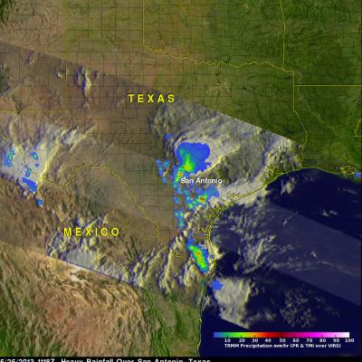
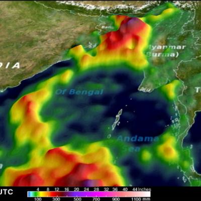
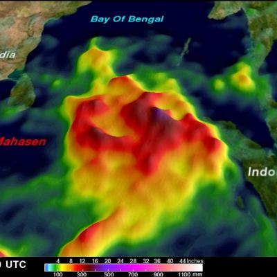
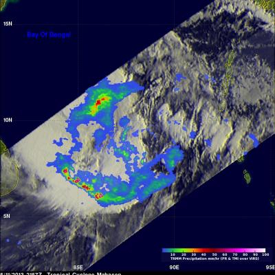
Hurricane Barbara Comes Ashore in Southern Mexico

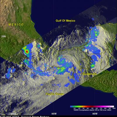
Hurricane Barbara recently made landfall along the southern Pacific coast of Mexico. According to the National Hurricane Center (NHC), the center of the storm came ashore around 19:50 UTC (12:50 pm PDT) Wednesday May 29th about 35 km (~20 miles) west of Tonala, Mexico as a minimal Category 1 hurricane with maximum sustained winds of 75 mph. TRMM captured the first image of Barbara several hours after it made landfall. The image was taken at 6:46 pm PDT 29 May (01:46 UTC 30 May) 2013 and shows the horizontal distribution of rain intensity within the storm. Rain rates in the center of the swath

TRMM Sees Powerful Storm Over San Antonio

Three people died this past weekend from flooding in San Antonio, Texas. The TRMM satellite flew above Texas early Saturday morning at 1118 UTC (6:18 AM CDT) when powerful thunderstorms were drenching San Antonio. Data captured with this orbit by TRMM's Microwave Imager (TMI) and Precipitation Radar (PR) were used in this rainfall analysis. TRMM's Precipitation Radar (PR) instrument found rain falling at a rate of over 66 mm/hr (~2.5 inches) in one violent thunderstorm shown near the center of this image. This 3-D image shows a TRMM Precipitation Radar (PR) slice through storms over Texas. One

Deadly Tropical Cyclone Mahasen Comes Ashore

Tropical cylone Mahasen hit southern Bangladesh causing the reported deaths of at least 12 people and the destruction of many homes. Mahasen had heavy rains accompanied with tropical storm force winds when it came ashore. The TRMM satellite had two very informative views as deadly tropical Cyclone Mahasen was moving toward and then over Bangladesh. TRMM passed above Mahasen on May 15, 2013 at 2133 UTC and saw Mahasen again on May 16, 2013 at 0406 UTC after the tropical cyclone's center passed over Bengladesh's Ganges Delta. Red tropical cyclone symbols mark Mahasen's locations with both TRMM

Tropical Cyclone Mahasen Rain Moving Into Bay Of Bengal

Tropical cyclone Mahasen is moving through the Bay of Bengal and is predicted by the Joint Typhoon Warning Center to impact southeastern Bangladesh and northwestern Myanmar (Burma) in about 4 days. This analysis shows a TRMM Multisatellite Precipitation Analysis (TMPA) of rainfall that occurred with tropical cyclone Mahasen during the past week. So far rainfall from Mahasen has fallen mainly over the open waters of the northern Indian Ocean and the Bay Of Bengal. Rainfall totals of about 500mm (~19.7 inches) are shown east of Indonesia in this analysis. Click here to see a rainfall total

Tropical Cyclone Mahasen Moving Into The bay Of Bengal

The TRMM satellite again flew almost directly above intensifying tropical cyclone Mahasen (01B) on May 11, 2013 at 2157 UTC. Rainfall data from TRMM's Microwave Imager (TMI) and Precipitation Radar (PR) instruments are shown overlaid on an infrared image from the Visible and InfraRed Scanner (VIRS). TRMM PR data found that the heaviest rainfall was falling at a rate of over 142 mm/hr (~5.6 inches) in a band of powerful storms well to the southwest of Mahasen's center. At the time of this TRMM pass Mahasen's winds were estimated to be about 50kts (~58 mph). Mahasen's winds are predicted to

TRMM Sees Tropical Cyclone 01B

The TRMM satellite passed above a developing tropical cyclone in the northern Indian Ocean west of Indonesia on May 9, 2013 at 2211 UTC. This image shows that tropical cyclone 01B was already fairly well organized. TRMM's Precipitation Radar (PR) instrument indicated that rainfall was falling at a rate over 178 mm/hr (~5.8 inches) in an area of strong convection in the middle of the forming tropical cyclone. The tropical cyclone is a little unusual because it formed only 4.8 degrees north of the equator. Coriolis force, an artifact of the earth's rotation, is weaker near the equator so

Zane Heading Towards Queensland Australia

Cyclone Zane, which as of 12:00 UTC (10:00 pm Australian Eastern Standard Time or AEST) 1 May 2013, was located about 215 km (~133 miles) due east of the coast of Queensland, Australia. TRMM captured this recent image of Cyclone Zane at 11:48 UTC (9:48 pm AEST) 1 May 2013. At the time, the center of circulation was located about 215 km (~133 miles) due east of the coast of Queensland, Australia and was heading west-northwest. TRMM reveals that Zane is still not very well organized with no eye visible and very little evidence of banding (curvature) in the rain area. At the time of this image

Heavy Weekend Rainfall Causes Flooding In Texas

Warm moist air from the Gulf of Mexico collided with a cold front resulting in extremely heavy rainfall in eastern Texas over the weekend. Rapid flooding resulted from reported rainfall of up to seven inches near Houston, Texas. The rainfall analysis was derived from the TRMM-based, near-real time Multi-satellite Precipitation Analysis (TMPA) at the NASA Goddard Space Flight Center. These rainfall data are derived from a TRMM-calibrated merger of various other satellite rainfall data. TMPA rainfall totals are shown here for the 3-day period from April 26-29, 2013. This analysis shows that

Recent Flooding in the Midwest, 5 Year Anniversary of 2008 Flood

An advancing frontal system extending from the Great Lakes region all the way down to the Gulf Coast supported a line of widespread storms and thunderstorms that brought heavy rain to parts of Iowa, Illinois, Missouri, and Indiana. The hardest hit area was northern Illinois where flooding was reported in and around Chicago. The scenario was set up by a deep upper-level trough that moved out of the Rockies and into the Plains. Strong southerly winds ahead of the trough allowed warm, moist air from the Gulf of Mexico to stream northwards all the way up to Lake Michigan. The TRMM-based, near-real

TRMM Sees Tropical Cyclone Imelda

The TRMM satellite flew directly over an intensifying tropical cyclone called Imelda in the South Indian Ocean on April 8, 2013 at 0447 UTC. This rainfall analysis used data collected with TRMM's Microwave Imager (TMI) and Precipitation Radar (PR) instruments. This analysis shows a large area of rainfall on the western side of the developing tropical cyclone. TRMM PR found that some powerful convective storms in this area were dropping rain a rate of over 86mm/hr (~3.4 inches).