TRMM News

Debby's Remnants Will Slightly Affect Bermuda

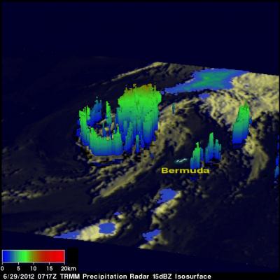
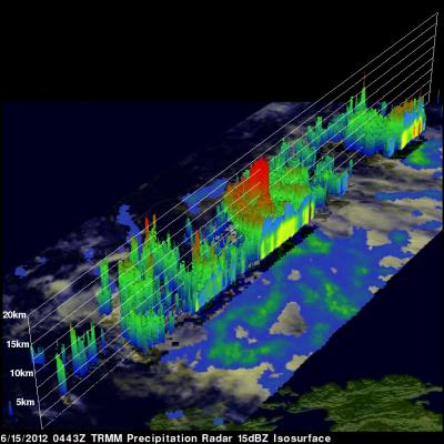
The remnant low pressure center from tropical storm Debby is predicted to kick up winds to gale force and cause a few showers today as it passes to the northwest of Bermuda. The TRMM satellite passed over the low early this morning at 0717 (4:17 AM ADT). TRMM Microwave Imager (TMI) and Precipitation Radar (PR) data show that Debby's remnant low contained a few light to moderate showers. A 3-D view using TRMM PR data shows that the most powerful of these storms were only reaching heights of about 10km (~6.2 miles).

Tropical Storm Debby Drenches Florida

Even though it never became more than a tropical storm, the residents of northern and central Florida will remember Debby. Debby, which formed as a tropical storm on the 23rd of June 2012 in the central Gulf of Mexico, took three full days to reach the Big Bend of Florida just 350 miles away. Although the center didn't make landfall until around 5 pm on the afternoon of the 26th when it crossed the coast near Steinhatchee, Florida, Debby's effects were felt well away from the center. Most of the rain and weather associated with Debby were well to the north and east of the center over Florida

Tropical Storm Debby Threatens Florida Gulf Coast

Tropical Storm Debby formed on the 23rd of June 2012 in the central Gulf of Mexico, becoming the earliest 4th named storm on record. Debby began as an area of low pressure that moved out of the northwestern Caribbean and into the Gulf. After forming on the afternoon of the 23rd, Debby has moved very slowly under the influence of weak steering currents. Debby drifted ever so slowly northward on the night of the 23rd before turning northeast later on the morning of the 24th towards the northeast Gulf Coast of Florida. Despite its slow forward progress and lack of intensification, Debby has

Tropical Storm Debby

The TRMM satellite traveled directly above tropical storm Debby's location early this morning at 0656 UTC ( 2:56 AM EDT). TRMM Microwave Imager (TMI) and Precipitation Radar (PR) data from that pass shows that Debby was dropping heavy rainfall in a large area on the eastern side of the Gulf Of Mexico. Most of the powerful convective storms producing this rainfall are shown by TRMM to be located well to the northeast of Debby's center of circulation. A forecast track from the National Hurricane Center (NHC) was overlaid on the image above. It shows that Debby is expected to stengthen and travel

Strong Storms Bring Heavy Rain, Flooding to Upper Midwest

An upper-level trough of low-pressure dropping down out of the Canadian Rockies in combination with a persistent frontal boundary and high pressure over the Southeast, combined to bring about strong storms and flooding over the Upper Midwest. The storms brought the worst flooding on record to Duluth, Minnesota where as much as 10 inches of rain were reported over a 2-day period from 19th to the 20th of June, resulting in flash flooding and many washed out roads. Even the zoo was flooded. Washed out roads were blamed for 3 fatalities in nearby Wisconsin. Counter-clockwise flow around high

Tropical Storm Talim Weakens, Moves Over Japan

Both Taiwan and Southern Japan have had extreme amounts of rainfall contributed by tropical cyclones during the past week. Tropical storm Talim weakened to a tropical depression on June 18, 2012 after passing over the northern tip of Taiwan. Flooding, landslides and at least one death in Taiwan were reportedly caused by Talim. The weakening tropical depression is now affecting Japan in areas that were just drenched by Typhoon Guchol's passage. This image shows rainfall from data collected with two TRMM satellite orbits as it passed over that area. TRMM passed over on June 20, 2012 at 2308 UTC

Tropical Storm Talim's Heavy Rainfall Over Taiwan

Tropical storm Talim has produced torrential rainfall over southern Taiwan as it pumped warm moist air from the South China Sea over mountainous terrain. The TRMM satellite flew over tropical storm Talim in the Taiwan Strait on 20 June 2012 at 0140 UTC. TRMM Precipitation Radar (PR) data from this orbit shows that tropical storm Talim was dropping rainfall at a rate of almost 50mm/hr over Taiwan. TRMM data captured with that orbit shows that the most intense rainfall of over 50mm/hr (~2 inches) was located over the Strait Of Taiwan. Flash flooding and landslides are probable in southern Taiwan

Guchol's Rainfall Drenching Japan

The TRMM satellite passed above weakening typhoon Guchol on 18 June 2012 at 2322 UTC as it moved toward Japan's main island of Honshu. Guchol's past and predicted locations are shown overlaid in white. A precipitation analysis from TRMM's Microwave Imager (TMI) and Precipitation Radar (PR) instruments show that the Japanese islands of Kyushu and Shikoku were getting rainfall from Guchol at the time of that orbit. Guchol was shown by TRMM to be enhancing rainfall in parts of Japan over 500 km (~310.7 miles) from the typhoon's center.

Hurricane Carlotta Moves Toward Mexican Coast

The TRMM satellite flew over hurricane Carlotta again on Friday June 15, 2012 at 1018 UTC. TRMM's Microwave Imager (TMI) showed that Carlotta was much better organized and revealed a developing eye. Heavy rainfall in bands spiraling into the center of Carlotta are shown by TRMM's Precipitation Radar (PR). Past positions and the National Hurricane Center's forecast positions are shown overlaid in white. Carlotta is forecast to become a category two hurricane tomorrow with sustained wind speeds increasing to 85kts (~98 mph) as it nears the Mexican coast.

Intensifying Typhoon Guchol Viewed By TRMM

Typhoon Guchol in the western Pacific Ocean is becoming increasingly more powerful and was seen by the TRMM satellite on Friday June 15, 2012 at 0443 UTC. The center of the intensifying typhoon was covered very well by TRMM's Precipitation Radar (PR) data. TRMM PR showed that very heavy rainfall was occurring in the eastern side of Guchol's eye wall. This 3-D image (looking toward the east) from TRMM PR data reveals that towering storms in the eastern side of Guchol's eye were reaching the amazing height of almost 17km (~10.56 miles). Intense rainfall in Guchol's eye wall was returning values