TRMM News

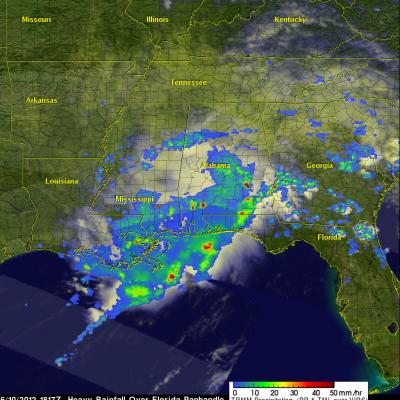
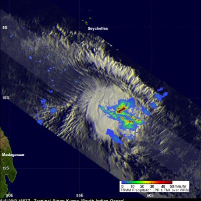
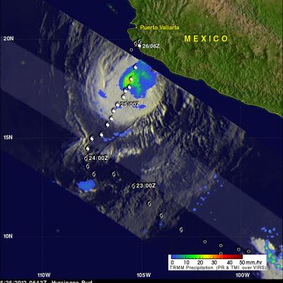
Tropical Storm Guchol Slowly Strengthens

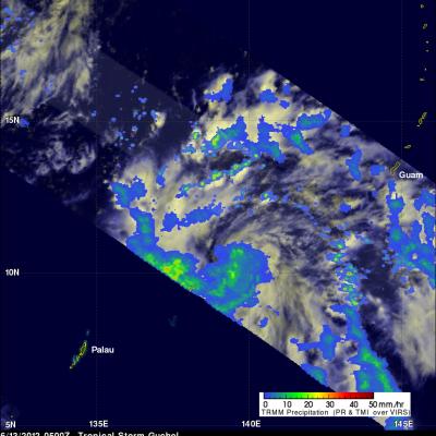
The tropical depression (05W) that became tropical storm Guchol yesterday formed southeast of Guam on June 11, 2012. TRMM had a fairly good daytime look at Guchol on June 13, 2012 at 0500 UTC. TRMM's Microwave Imager (TMI) data revealed that Guchol contained a large area of moderate to heavy rainfall. Guchol is expected to continue moving toward the northwest, slowly intensify and reach minimal typhoon strength on June 14, 2012.

TRMM Sees Flooding Rainfall Along Gulf

The states along the coast of the Gulf of Mexico experienced very heavy rainfall on Saturday June 9,2012 and Sunday June 10, 2012. The images above use TRMM satellite data collected when it flew over on Sunday June 10, 2012. Unusually heavy rainfall was occurring in states near the Gulf coast. Due to the path of TRMM's orbits it had good coverage with more than one orbit. The first orbit occurred at 1501 UTC (11:01 AM EDT). The second image shows a combination of more than one orbit with the later data being collected at about 1817 UTC (2:17 PM EDT). TRMM rainfall analyses from these orbits

Late Season Tropical Storm Kuena Forms

A tropical storm called Kuena formed in the southwest Indian Ocean east of Madagascar on June 6, 2012. This is a little unusual because the tropical cyclone season in that area normally ends on May 15. The TRMM satellite had an excellent view of Kuena when it flew directly above the newly formed storm on June 6, 2012 at 1607 UTC. A rainfall analysis that used data from TRMM's Microwave Imager (TMI) and Precipitation Radar (PR) instruments is shown overlaid on an enhanced infrared image from TRMM's Visible and InfraRed Scanner (VIRS) instrument. This analysis shows that heavy convective storms

Tropical Storm Beryl Brings Some Much Needed Drought Relief to Southeast US

Tropical Storm Beryl was actually a welcome sight in parts of the Southeast. Tropical cyclones are not always bad news. Sometimes they can be quite beneficial, especially when it comes to relieving drought conditions. Tropical Storm Beryl made landfall just after midnight (local time) on the night of 27 May 2012 near Jacksonville Beach, Florida as a strong tropical storm with sustained winds of 70 mph, making it the strongest tropical cyclone to make landfall in the US before the official June 1st start of the Atlantic hurricane season. Prior to the arrival of Beryl, many parts of the

Tropical Depression Beryl Drenches Florida And Georgia

At times Tropical storm beryl has been producing intense rainfall over the southeastern United States since coming ashore early on Monday May 28, 2012. The TRMM satellite had good views of Beryl's rainfall on Monday May 28, 2012 at 2033 UTC (4:33 PM EDT) and on Tuesday May 29, 2012 at 0127 UTC (Monday May, 28 2012 at 9:27 PM EDT). Data from TRMM's Microwave Imager (TMI) and Precipitation Radar (PR) are shown in two images from those orbits. These TRMM images show that bands of rainfall rotating around Beryl were mainly affecting only northern Florida and southeastern Georgia. A few areas of

Hurricane Bud Threatens Western Mexico's Coast

The TRMM satellite passed above hurricane Bud early this morning at 0429 UTC (9:30 PM PDT May 24, 2012). A large area of moderate to heavy rainfall with rates of over 30mm/hr (~1.2 inches) was revealed in Bud by TRMM's Microwave Imager (TMI) instrument. The rainfall analysis was overlaid on an enhanced infrared image derived from TRMM's Visible and InfraRed Scanner (VIRS). Bud's past and predicted locations are shown overlaid in white. Heavy rainfall from hurricane Bud's slow movement may result in severe flooding and dangerous landslides as it moves over Mexico's rugged coastal terrain.

Tropical Cyclone Season Gets Started in the Northern Hemisphere

Summer has not yet arrived, and yet there are currently 3 active tropical systems in the Northern Hemisphere spread across three different ocean basins. Perhaps, the most unusual of the three is Tropical Storm Alberto in the Atlantic. Alberto formed in the western Atlantic from a stationary low pressure system off of the coast of South Carolina on the 19th of May 2012, two weeks before the official June 1st start of the Atlantic hurricane season. Alberto is the first tropical storm to form this early in the season since Tropical Storm Ana in 2003, which formed on the 20th of April west of

TRMM Sees First Atlantic Tropical Storm Forming

The TRMM satellite flew above tropical storm Alberto when it was forming off the coast of South Carolina today. TRMM Microwave Imager (TMI) and Precipitation Radar (PR) data captured at (12 minutes after midnight EDT) were used in the rainfall analysis shown above. It shows a large area of moderate to heavy rainfall with a small area of heavy rainfall located near the center of the forming tropical cyclone.

Another Tropical Cyclone Developing

While Tropical storm Aletta is forecast to weaken and dissipate another tropical cyclone appears to be forming in the eastern Pacific south of Acapulco, Mexico. The TRMM satellite passed above this tropical disturbance (92E) on 18 May 2012 at 0957 UTC. Data captured with this pass by TRMM's Microwave Imager (TMI) and Precipitation Radar (PR) instruments were used in the rainfall analysis shown. This analysis indicates that this area contained very heavy rainfall in the northeastern quadrant of the disturbance. Some storms were producing rainfall at a rate of over 50 mm/hr (~2 inches). A 3-D