TRMM News

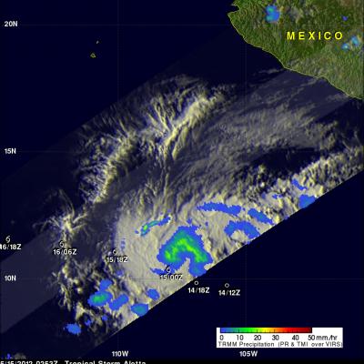
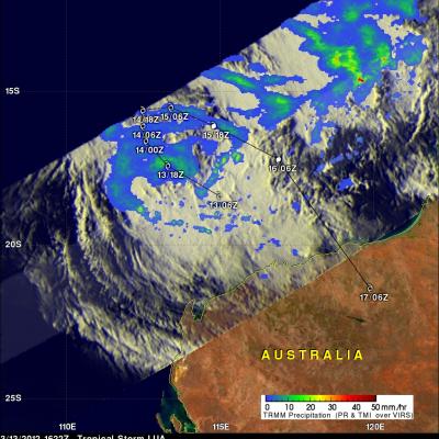
TRMM Sees Disorganized Aletta

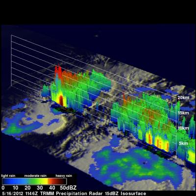
The TRMM satellite passed almost directly above tropical storm Aletta in the eastern Pacific Ocean on 16 March 2012 at 1146 UTC. Data from TRMM's Microwave Imager (TMI) and Precipitation Radar (PR) instruments were used in the rainfall analysis shown above. Aletta's past and future positions are shown overlaid in white. Aletta looks disorganized in this orbit but some very heavy thunderstorms, producing rainfall at a rate greater than 50mm/hr (~2 inches), were located near the storm's center. TRMM's Precipitation Radar (PR) found that some thunderstorms contained very heavy rainfall with a

Tropical Storm Aletta Forms

The eastern Pacific hurricane season starts today. Just slightly ahead of schedule tropical storm Aletta formed yesterday well to the southwest of the Mexican coast. The image above uses data captured when the TRMM satellite passed above Aletta on 15 May 2012 at 0253 UTC. TRMM's Microwave Imager (TMI) instrument had a good look at the newly formed storm and showed that Aletta had a large area of light to moderate rainfall north of the storm's center of circulation. The TMI rainfall analysis is shown overlaid on an enhanced infrared image from TRMM's Visible and InfraRed Scanner (VIRS)

TRMM Sees Tropical Cyclone 19S

Tropical cyclones are more likely to form in the northern hemisphere in May so tropical cyclone 19S is a little unusual. Tropical cyclone 19S attained tropical storm intensity in the Banda Sea on 7 May 2012. 19S is expected to quickly weaken to tropical depression intensity with wind speeds of about 25 kts (~29 mph) as it moves southward into the Timor Sea north of Australia. The TRMM satellite has been useful for monitoring the development of tropical cyclones over the global tropics. TRMM flew above tropical cyclone 19S during the daylight on 8 May 2012 at 0213 UTC. A rainfall analysis from

Dominican Republic And Haiti Hit By Deadly Floods

It has been reported that spring floods with mudslides have resulted in the death of at least 9 people and forced 11,000 people to flee their homes in the Dominican Republic. Data from the TRMM satellite are used to calibrate rainfall data merged from various satellite sources. TRMM-based, near-real time Multi-satellite Precipitation Analyses (TMPA) at the NASA Goddard Space Flight Center are used to monitor rainfall over the global Tropics. TMPA rainfall estimates are shown above for the week from April 19 to April 26, 2012. This analysis shows that extreme rainfall (shown in dark red)

Tornadoes Devastate Parts of the Great Plains

It's springtime in the Plains, which means the increased likelihood that severe weather, including tornadoes, will occur somewhere across the region. After a week of relative quiet, a strong storm system moved out of the southern Rockies and out into the Central Plains. In association with this system, strong southerly winds at low levels drew Gulf moisture up across Texas and into Oklahoma and Kansas while strong jet-stream winds aloft raced northeastward around the base of an upper-level trough over the four-corners region and out over the Plains, setting the stage for a potential severe

NASA's TRMM Satellite Sees Tornadic Texas Storms in 3-D

NASA's Tropical Rainfall Measuring Mission (TRMM) satellite provides a look at thunderstorms in three dimensions and shows scientists the heights of the thunderclouds and the rainfall rates coming from them, both of which indicate severity. Powerful thunderstorms that created severe weather were more than 8 miles high. The TRMM satellite passed above northeastern Texas on April 3, 8:33 p.m. CDT and gathered rainfall and cloud height data from a line of thunderstorms moving through the area. The rainfall image above shows a distinct line of tornadic thunderstorms extending from Arkansas through

Pakhar Becomes a Typhoon

Tropical storm Pakhar was upgraded to typhoon intensity shortly after the TRMM satellite passed over head again on 29 March 2012 at 2114 UTC. An analysis of TRMM Microwave Imager (TMI) and Precipitation Radar (PR) rainfall are shown overlaid on an enhanced infrared image from the Visible and InfraRed Scanner (VIRS) instrument. TMI rainfall data indicated that the largest area of precipitation was located to the southwest of the storm's center. PR data shows that there were scattered powerful storms around Pakhar dropping rainfall at a rate of over 50mm/hr (~2 inches). Pakhar's is forecast to

Typhoon Pakhar Moving Toward Vietnam

The TRMM satellite flew almost directly over a newly formed tropical storm in the South China Sea on 29 March 2012 at 1122 UTC. Pakhar is the first typhoon to form in the northern hemisphere this year. The intensifying storm had wind speeds of about 45 kts (~52 mph) and was moving toward the west-northwest when viewed by this TRMM pass. Pakhar is predicted to be stronger with wind speeds of at least 60 kts (~69 mph) when it crosses into southeastern Vietnam on 31 March 2012. The rainfall analysis above used data from TRMM's Microwave Imager (TMI) and Precipitation Radar (PR) instruments. It

Record Rainfall Continues Over Australia

Over the past month northeastern Australia has continued to receive record rainfall from the monsoon trough that has been draped over that area. The Australian Bureau of Meteorology has indicated that some recorded rainfall rates are seen only once in 100 years. Flooding rainfall amounts have been especially extreme near the coasts of northeastern Australia. For increased coverage, TRMM data can be used to calibrate rainfall estimates from other satellites. The TRMM-based, near-real time Multi-satellite Precipitation Analysis (TMPA) at the NASA Goddard Space Flight Center is used to monitor

TRMM Sees Tropical Storm Lua's Formation

A tropical storm called LUA formed in the Indian Ocean off Australia's northwestern coast on 13 March 2012. This area of Australia is sparsely populated but LUA caused the shutdown of over one quarter of the country's crude oil production. The TRMM satellite flew over this area on 13 March 2012 at 1622 UTC. A Rainfall analysis using TRMM's Microwave Imager (TMI) and Precipitation Radar (PR) instruments is shown overlaid on an enhanced infrared image from TRMM's Visible and InfraRed Scanner (VIRS). This analysis indicates that rainfall intensity was mainly in the moderate range of 20 to 30 mm