TRMM News

Typhoon MA-ON Threatening Japan

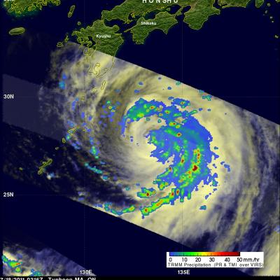
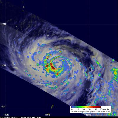
Typhoon MA-ON was a category 2 typhoon on the Saffir/Simpson scale with wind speeds of about 85 kts (~98 mph) when the TRMM satellite captured those data shown above on 18 July 2011 at 0316 UTC. MA-ON had weakened considerably from a very powerful category four typhoon with wind speeds of 115 kts (~132 mph) on 15 July 2011. TRMM's Microwave Imager (TMI) and Precipitation Radar (PR) data were used to produce the rainfall analysis shown above. This TRMM analysis shows that MA-ON still contained organized bands of very intense rainfall with the most intense precipitation located in the eastern

TRMM Sees Powerful Typhoon MA-ON

The TRMM satellite passed almost directly above powerful typhoon MA-ON on 14 July 2011 at 0525 UTC. This TRMM orbit revealed that MA-ON was extremely well organized with several bands of intense thunderstorms around a well defined eye. This rainfall analysis, using data from TRMM's Microwave Imager (TMI) and Precipitation Radar (PR), shows that the heaviest rainfall of over 50 mm/hr (~ 2 inches) was located in the southwestern quadrant of MA-ON's eye wall. MA-ON is predicted to become an even more dangerous super typhoon with wind speeds of 135 kts (155 mph) on 17 July 2011 while approaching

Tropical Storm 08W Becomes Stronger

Tropical storm MA-ON (08W), that developed east of the Marianas in the northern Pacific Ocean yesterday, has continued to become more powerful. MA-ON had wind speeds of about 35 kts (~40 mph) when the TRMM satellite saw the storm on 12 July 2011 at 0640 UTC and is predicted to gradually strengthen over the next five days. MA-ON is then expected to be a powerful typhoon with wind speeds of 95 kts (~109 mph) and be located in the open waters of the Pacific Ocean south of Japan. TRMM Microwave Imager (TMI) and Precipitation Radar (PR) data were used in the rainfall analysis being drawn on the

TRMM Sees Developing Western Pacific Tropical Cyclone

The TRMM satellite flew over newly designated tropical depression 08W in the western Pacific Ocean on 11 July 2011 at 0637 UTC. The rainfall analysis on the left above, derived from TRMM Microwave Imager (TMI) and Precipitation Radar (PR) data, shows that numerous convective thunderstorms were dropping moderate to heavy rainfall over a large area of the Pacific Ocean near 18.1N 157.3E. The Naval Maritime Forecast Center Pearl Harbor, HI (NMFC-PH) predicts that 08W will become a typhoon over the open waters of the Pacific with 65kt (~75 mph) winds by 13 July 2011. The 3-D display above uses PR

Tropical Depression Three Intensifying

Tropical depression Three was showing much better organization with more heavy rainfall when the TRMM satellite saw it again on 7 July 2011 at 1636 UTC. Data from TRMM's Microwave Imager (TMI) showed that heavy rainfall was present in a large area over the center of the intensifying depression and in a feeder band to the west of the center. There were also a few showers shown along the Mexican coast to the northwest of the storm.

TRMM Sees Tropical Depression Forming

The TRMM satellite passed over an area of low pressure in the eastern Pacific Ocean south of Mexico on 7 July 2011 at 0234 UTC. The National Hurricane Center (NHC) in Miami, Florida upgraded this area of low pressure to a tropical depression at 1500 UTC ( 08:00 AM PDT) making it the third tropical depression in the eastern Pacific this hurricane season. Conditions are expected to be favorable for the depression to become a tropical storm within the next couple days. The rainfall analysis from TRMM's Microwave Imager (TMI) and Precipitation Radar (PR) data was overlaid on an infrared image from

Arlene Brings Heavy Rains to Mexico

Arlene formed into a tropical storm on the evening of 28 June 2011 in the Bay of Campeche in the southwestern Gulf of Mexico from an area of low pressure that had formed the day before just west of the Yucatan Peninsula. Arlene did not have time to fully develop and came ashore as a strong tropical storm two days later on the morning of 30 June near Cabo Rojo along Mexico's east coast with sustained winds reported at 65 mph. Although wind damage from the storm was relatively minor, Arlene brings the threat of heavy rains and flash flooding to the region as it continues to move inland. The

Arlene Is First 2011 Atlantic Tropical Storm

The National Hurricane Center (NHC) named Tropical Storm Arlene the first tropical storm of the 2011 Atlantic hurricane season on 29 June 2011 at 0000 UTC (7 PM CDT). The TRMM satellite had a good look at Arlene when it passed above on 29 June 2011 at 0502 UTC (0:02 AM CDT). At that time Arlene's winds were estimated to be about 34 knots (~39 mph) indicating that it was barely a tropical storm. TRMM's Microwave Imager (TMI) and Precipitation Radar (PR) data were used in the analysis on the upper left and show that Arlene was getting better organized and contained scattered heavy thunderstorms

TRMM Sees Arlene Threatening Mexico

The TRMM satellite again flew over tropical storm Arlene on 30 June 2011 at 0408 UTC before the first tropical storm of the Atlantic hurricane season came ashore in Mexico. Arlene had become a strong tropical storm with sustained winds of about 55 kts (~63 mph). The rainfall analysis above is from TRMM's Microwave Imager (TMI) and Precipitation Radar (PR). It shows that Arlene contained areas of very heavy rainfall. A few rain showers from Arlene were starting to reach Mexico and extreme southern Texas but at that time the most intense storms were still located in the Gulf Of Mexico east of

TRMM Monitors Southern Mexico's Rainfall

The TRMM satellite flew over an area of disturbed weather labeled 95L affecting southern Mexico on 27 June 2011 at 2148 UTC (5:48 PM EDT). The TRMM rainfall analysis shown above used TRMM's Microwave Imager (TMI) and Precipitation Radar (PR) data. It shows that heavy rainfall of over 50mm (~2 inches) associated with 95L was occurring in southern Mexico northwest of Veracruz and over the Yucatan Peninsula. Some of this very heavy rainfall may result in flash flooding and mudslides. The National Hurricane Center (NHC) is watching this area and has indicated that there is a slight chance that a