Tropical Storm Gordon's Rainfall Measured With IMERG
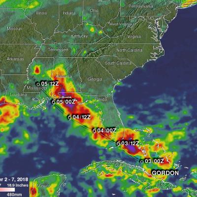
Tropical Storm Gordon became the seventh named system of the 2018 Atlantic hurricane season on Monday September 3, 2018. GORDON became more intense as it moved through the eastern Gulf Of Mexico but didn't quite make it to hurricane force before landfall. GORDON was a strong tropical storm with winds of about 70 mph (~ 61 kts) when it hit southeastern Mississippi on September 5, 2018. GORDON continued to produce rainfall as it moved inland. Weakening GORDON spawned a tornado near Picayune, Mississippi on Thursday September 6, 2018. Today, tropical depression GORDON is still responsible for