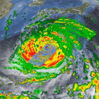
Extreme Weather News

Jump to a Year

2024 | 2023 | 2022 | 2021 | 2020

2019 | 2018 | 2017 | 2016 | 2015

2014 | 2013 | 2012 | 2011 | 2010

2009 | 2008 | 2007 | 2006 | 2005

2004 | 2003 | 2002

GPM Overpass of Typhoon Surigae
Although it was only the 2nd named storm of the 2021 Pacific typhoon season, Typhoon Surigae became not only the first super typhoon of the season, but also the strongest tropical cyclone of 2021 worldwide. The majority of storms in the Northwest Pacific region form between June and Nov., but the season runs yearlong, as storms can form in any month in this region, which stretches from 100 degrees East to 180 degrees East, north of the equator. Surigae originated from an area of low pressure about 700 miles south of Guam. Persistent thunderstorm activity resulted in the formation of a tropical
IMERG Rainfall Totals from Australian :"Rain Bomb" in March 2022
The below animation shows surface rainfall estimates from NASA’s IMERG multi-satellite precipitation product for the week starting on Feb. 22, 2022 at 0000 UTC and ending on Feb. 28, 2022 at 2330 UTC. Areas shaded in blue and yellow show three-hour average snapshots of IMERG rain rates every half-hour overlaid on cloudiness (shown in white/gray) based on geosynchronous satellite infrared observations. Below the rain rates and cloudiness data, IMERG rainfall accumulations are shown in green and purple. Tropical Cyclone Anika’s track is shown with a gray line based on data from the U.S. Navy-Air
IMERG rainfall totals from the Nov. 2021 atmospheric river.
The Pacific Northwest coast saw two atmospheric rivers (ARs) bring heavy rains from Nov. 10-16, 2021, resulting in severe flooding, landslides, and damage to infrastructure in the British Columbia province of Canada. ARs are long, narrow corridors of water vapor that travel vast distances above the ocean from warm, tropical regions to higher latitudes, where they often release their moisture as rainfall when they reach land areas. While ARs occur across the globe, this year has been notable for several strong events that have impacted the Pacific Northwest coast. The two atmospheric rivers in
IMERG rainfall totals from recent atmospheric river.
The Pacific Northwest experienced a memorable series of storms in late Oct. 2021 as several low-pressure systems rolled in from the northeast Pacific Ocean. One of the systems was classified by meteorologists as a “bomb cyclone”, meaning that its central pressure (an indication of storm strength) had dropped particularly rapidly in a short time period. At its minimum pressure (highest strength), the system was reported by the National Weather Service to have had the lowest pressure of a system over the northeastern Pacific Ocean since reliable observations began in 1974. The system was notable
IMERG Comparison of Typhoon Mindulle and Hurricane Sam
From late Sept. through early Oct. 2021, two powerful storms churned over the Pacific and Atlantic Oceans: Typhoon Mindulle, which peaked as a Category 5 storm, and Hurricane Sam, a Category 4 hurricane and one of the longest-lived hurricane-strength storms on record over the Atlantic Ocean. While neither storm posed a direct threat to land, Mindulle brushed by eastern Japan, leaving heavy rainfall accumulations in the area near Tokyo. Despite the fact that neither storm made landfall, the storms’ slow-motion tracks across warm ocean waters allows an opportunity to observe how the strong winds