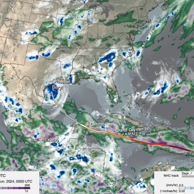
Extreme Weather News

Jump to a Year

2024 | 2023 | 2022 | 2021 | 2020

2019 | 2018 | 2017 | 2016 | 2015

2014 | 2013 | 2012 | 2011 | 2010

2009 | 2008 | 2007 | 2006 | 2005

2004 | 2003 | 2002

GPM Overpass of Cyclone Bolaven
Typhoon Bolaven began as a tropical depression over the West Pacific Ocean on Oct. 7, 2023. On Oct. 10, Bolaven became a Typhoon and passed over the Mariana Islands as it tracked to the northwest. Bolaven then rapidly intensified over 12 hours from a Category 1 to a Category 5 storm on the Saffir-Simpson scale, starting around 12 UTC on Oct. 10. Several factors contributed to the rapid intensification, including modest shear in the atmosphere and warm sea-surface temperatures. This animation shows precipitation within Typhoon Bolaven around the time that rapid intensification began. The global
Map of IMERG precipitation estimates from recent flooding rainfall in Greece.
On Sept. 4, 2023, a low-pressure system developed over southeastern Europe that would lead to devastating floods over Greece and other parts of the region. The system was given the name “Daniel” by local meteorological agencies. Daniel was dynamically driven by strong cyclonic flow in the upper-level winds over southeastern Europe. The upper-levels winds combined with low-level winds from the northeast which supplied moisture from the unusually warm waters of the Aegean and Black Seas to central Greece. According to satellite infrared and microwave estimates from NASA's MUR and NOAA’s OISST v2
GPM Overpass of Hurricane Idalia
After threatening much of Florida’s western coast, Hurricane Idalia made landfall Wednesday morning in the Big Bend region of Florida’s northwest coast near Keaton Beach at 7:45 a.m. EDT, Aug. 30, as a strong Category 3 storm with sustained winds reported at 125 mph by the National Hurricane Center. Idalia’s formation was somewhat unusual. Typically, when entering the heart of the hurricane season tropical storms and hurricanes form and expand eastward across the tropical Atlantic region towards Africa’s coast. However, storms occasionally still form in the western Caribbean, as was the case
GPM Overpass of Tropical Storm Franklin on Aug. 29 2023
After becoming a tropical storm in the east-central Caribbean on the afternoon of Aug. 20 and moving generally westward for two days, Tropical Storm Franklin took a northward track and struck the southern coast of the Dominican Republic south of Barahona on the morning of Aug. 23 as a moderate tropical storm with sustained winds reported at 50 mph by the National Hurricane Center (NHC). Franklin brought heavy rains and flooding to the area, resulting in landslides, power outages and at least 2 fatalities in the Dominican Republic according to media reports. After traversing the mountainous
IMERG rainfall totals from Hurricane Hilary.
Hurricane Hilary is being hailed as a historic storm after becoming the first tropical storm to hit California since Sept. 24, 1939. The storm has had a large impact on the region - in addition to gusty winds, Hilary’s rains have resulted in widespread flooding, landslides, washed out roads and numerous other closures. Like most East Pacific tropical cyclones, Hilary originated from a westward propagating tropical wave that crossed over Central America from the western Caribbean into the eastern Pacific. Known as “African easterly waves”, these are the same waves that emerge off the coast of