Extreme Weather News

Jump to a Year

2024 | 2023 | 2022 | 2021 | 2020

2019 | 2018 | 2017 | 2016 | 2015

2014 | 2013 | 2012 | 2011 | 2010

2009 | 2008 | 2007 | 2006 | 2005

2004 | 2003 | 2002

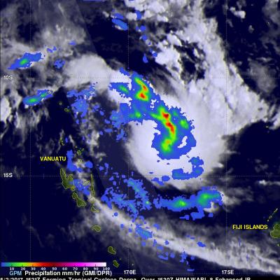
GPM Monitors Tropical Cyclone Donna

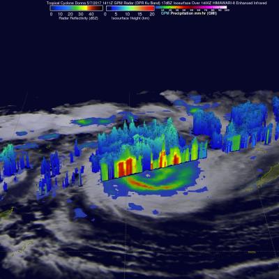
The above window displays an interactive visualization of GPM data collected from Tropical Cyclone Donna on 5/7/17. Over the weekend tropical cyclone Donna dropped very heavy rain over Vanuatu as it moved toward the west of the islands. Donna had intensified and had maximum sustained winds of 115 kts (132 mph) on Monday morning. This made it the equivalent of a category four on the Saffir-Simpson hurricane wind scale. The GPM core observatory satellite had two excellent views of the intensifying tropical cyclone Donna on succeeding days. When GPM flew over Donna on May 6, 2017 at 0146 UTC the

Tropical Cyclone Donna's Rain Unveiled By GPM

Tropical Cyclone Donna formed in the South Pacific Ocean northeast of Vanuatu On May 2, 2017 at 1800 UTC. A few hours earlier at 1521 UTC the GPM core observatory satellite passed above that area. GPM's Microwave Imager (GMI) instrument provided a clear view of the rainfall associated with the forming tropical cyclone. GMI revealed that an intense rain band was wrapping into the center of the forming tropical cyclone from the northern side. GMI data indicated that precipitation in one of these intense rain bands was falling at a rate of over 53 mm (~2 inches) per hour. GPM's Dual-Frequency

Extreme U.S. Rainfall Analyzed With IMERG Data

Tornadoes have accompanied severe weather over the United States almost daily during the past week. Severe storms spawned tornadoes from Texas and Oklahoma eastward through Mississippi. Upper Midwest states such Illinois, Indiana and Kentucky were also visited by tornadoes. Extreme rainfall caused deadly flooding in Missouri. More than a dozen people in the Midwest and South have been reported killed by tornadoes or flooding. The same weather system is spreading severe storms through East and Northeastern states today. NASA's Integrated Multi-satelliE Retrievals for GPM (IMERG) data were used

Intensifying Tropical Cyclone Francis Inspected By GPM

Tropical cyclone Francis formed north of Melville Island, Australia on April 27, 2017. Francis has been gradually intensifying while moving south-southwestward through the Timor Sea. Francis had maximum sustained winds estimated at 50 kts (57.5 mph) when the GPM core Observatory flew over on April 27, 2017 at 1936 UTC. The rainfall analysis shown here used data collected by GPM's Microwave Imager (GMI) and Dual-Frequency Precipitation Radar (DPR) instruments. DPR data indicated that strong convective storms near the center of the tropical storm were dropping rain at a rate of over 70 mm (2.8

Tropical Depression 03W In The Pacific Examined By GPM

Tropical Depression 03W formed in the Pacific Ocean west of Guam on April 24, 2017. The GPM core observatory satellite had an excellent view of TD03W when it flew over on April 14, 2017 at 1901 UTC. The GPM satellite found that the newly formed tropical depression contained some very powerful convective storms. Intense storms in the middle of the organizing convective cluster were dropping precipitation at extreme rates. GPM's Microwave Imager (GMI) and Dual-Frequency Precipitation Radar (DPR) instruments unveiled tall convective storm towers on the eastern side of this cluster of storms that