GPM Sees Powerful Storms With Advancing Monsoon
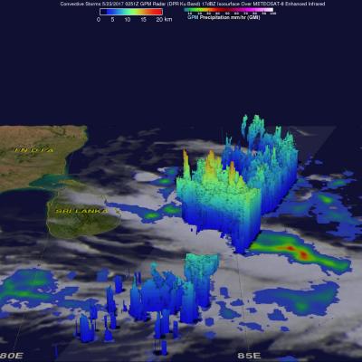
The GPM core observatory satellite passed over the Bay Of Bengal on May 23, 2017 at 0251 UTC. GPM flew almost directly above very strong convective storms that were located east of Sri Lanka. These powerful storms were associated with the approaching South-West monsoon. The amount and timing of monsoon rainfall is very important to the economy of India. GPM's Microwave Imager (GMI) and Dual-Frequency Precipitation Radar (DPR) instruments collected data that showed the location and intensity of rainfall in the southern Bay Of Bengal. Very heavy rainfall was detected within this cluster of