Extreme Weather News

Jump to a Year

2024 | 2023 | 2022 | 2021 | 2020

2019 | 2018 | 2017 | 2016 | 2015

2014 | 2013 | 2012 | 2011 | 2010

2009 | 2008 | 2007 | 2006 | 2005

2004 | 2003 | 2002

GPM Catches Nor'easter over New England
At the time of the Global Precipitation Measurement (GPM) Core Observatory overpass (April 1, 2017, 0550 UTC), the storm's center of low pressure was south of Long Island. At the mid-levels of the atmosphere, the circulation was centered over northeast Pennsylvania. This led to a classic overrunning, warm conveyor setup, which happened when the counterclockwise low level flow drew in cold air out of the north/northeast (hence "Nor'easter") from Canada. Higher up, warm and moist air from further south was lifted over this cold air and resulted in precipitation in the form of snow at the surface...

GPM Observes Tropical Cyclone Forming North of Australia

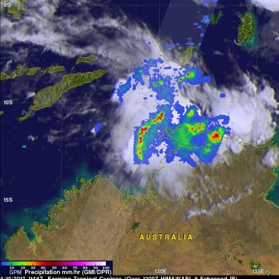
The GPM Core Observatory satellite flew directly above a forming tropical cyclone in the Timor Sea northeast of Darwin, Australia on April 10, 2017 at 1146 UTC. Data collected by GPM's Microwave Imager (GMI) and Dual-Frequency Precipitation Radar (DPR) instruments showed that convective storms within the tropical low contained very heavy rainfall. GPM's DPR (Ku Band) data revealed that a line of intense storms west of the Bathurst and Melville islands was dropping rain at a rate of over 161 mm (6.3 inches) per hour. A 3-D examination of the forming tropical cyclone's cloud tops showed that

Deadly Flooding Rains Near Mocoa, Colombia Measured By IMERG

Late Friday night and Saturday morning flash flooding and mudslides killed over 250 people in Mocoa, Colombia. Extremely intense storms added heavy rain to water logged terrain around Mocoa. Water from this heavy rainfall converged into a river that runs close to Mocoa causing it to overflow it's banks with deadly results. Integrated Multi-satellitE Retrievals (IMERG) data were used to estimate the amount of rain that fell near Mocoa, Colombia during the seven day period from March 26 to April 2, 2017. IMERG indicates that area rainfall totals during the week were frequently greater than 80 mm
GPM Measures Tropical Cyclone Debbie
Tropical cyclone Debbie formed in the Coral Sea northeast of Australia om March 24, 2017. Debbie intensified and had hurricane force wind speeds within a day of formation. While headed toward northeastern Australia Debbie reached it's maximum sustained wind speeds estimated at over 100 kts (115 mph) on March 27, 2017 (UTC). Tropical cyclone Debbie came ashore on March 28th and brought destructive winds and extremely heavy rain to northeastern Australia. It was reported that heavy rainfall caused flash flooding that cut off a coastal town and covered several roads in Queensland. The GPM...

Tropical Cyclone Caleb's Rainfall Revealed By GPM

Tropical cyclone Caleb formed today in the South Indian Ocean southwest of the Indonesian Island of Sumatra. The GPM core observatory satellite had a fairly good view of the the newly formed tropical cyclone when it flew over on March 23, 2017 at 0756 UTC. The satellite's Microwave Imager (GMI) revealed the locations of rainfall within the tropical cyclone. Rainfall measurements derived from the GMI showed that convective storms's were dropping rain at a rate of almost 84 mm (3.3 inches) per hour on Caleb's eastern side. The Joint Typhoon Warning Center (JTWC) predicts that tropical cyclone