Extreme Weather News

Jump to a Year

2024 | 2023 | 2022 | 2021 | 2020

2019 | 2018 | 2017 | 2016 | 2015

2014 | 2013 | 2012 | 2011 | 2010

2009 | 2008 | 2007 | 2006 | 2005

2004 | 2003 | 2002

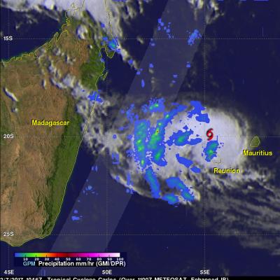
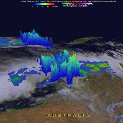
GPM Satellite Reveals Intensity Of Powerful Storms In The Timor Sea

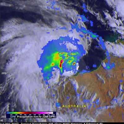
The GPM satellite flew over a stormy area of the Timor Sea northwest of Australia on February 7, 2017 at 1926Z. GPM found that this stormy area contained some extremely powerful convective storms. GPM's Dual-Frequency Precipitation Radar (DPR) found that the most intense storms were dropping rain at a rate of over 268 mm (10.6 inches) per hour. Data received by GPM's Radar (DPR Ku Band) also revealed the 3-D anatomy of precipitation hidden inside these unusually powerful storms. GPM's radar found that these storm tops were pushing to altitudes greater than 19 km (11.8 miles). GPM radar data

GPM Sees Carlos Moving Past Reunion Island

The GPM core observatory satellite flew above tropical cyclone Carlos on February 7, 2017 at 1056 UTC. Carlos was moving past Reunion Island with maximum sustained winds estimated at 45 kts (51.8 mph). GPM's Microwave Imager (GMI) and Dual-Frequency Precipitation Radar (DPR) data show that rain bands west of Carlos' center were producing heavy rainfall. GPM's DPR swath is shown in a lighter shade. DPR measured a few downpours in the bands west of the Carlos' center of circulation dropping rain at a rate of over 120 mm (4.7 inches) per hour. GPM's radar (DPR Ku Band) found that a few storm tops

Tropical Storm Carlos Forms

Tropical storm Carlos formed in the Southwest Indian Ocean north of the French Islands of Reunion and Mauritius on February 4, 2017 (UTC). This ended an unusual drought of tropical cyclone formation in that part of the Indian Ocean that began in July 2016. NASA's GPM core observatory satellite flew above tropical storm Carlos on February 5, 2017 at 1056 UTC when Carlos had maximum sustained winds of about 45 kts (51.8 mph). GPM collected data that showed the intensity and structure of precipitation within Carlos. GPM's Dual-Frequency Precipitation Radar (DPR) measured rain falling at a rate of

GPM Sees Possible Tropical Cyclone Developing Near Australia

So far this year no tropical cyclones have developed in the Southwest Indian Ocean. The Joint Typhoon Warning Center (JTWC) recently warned that a low moving westward over northwestern Australia may soon become a tropical cyclone. Warm Indian Ocean waters and low vertical wind shear are providing a good environment for tropical cyclone development. The GPM satellite flew over northwestern Australia on January 25, 2017 at 2351 UTC. GPM's Microwave Imager (GMI) and Dual-Frequency Precipitation Radar (DPR) measured precipitation within strong convection in the Indian Ocean northwest of the lows

Mudslides & Flooding Produced By Extreme Rainfall Over Southern California

It is sunny in southern California today but recent unusually heavy rainfall led to rock slides, mudslides and flooding in that part of the country. Rainfall of almost 4 inches (101.6 mm) in one day was reported in Long Beach, California. Some highways in the area were flooded due to intense downpours. Rainfall since the fall of 2016 has improved drought conditions over northern California but Southern California has been slower to improve because of the exceptional rainfall deficit in that area. NASA's Integrated Multi-satellitE Retrievals for GPM (IMERG) were used to estimate the total