Extreme Weather News

Jump to a Year

2024 | 2023 | 2022 | 2021 | 2020

2019 | 2018 | 2017 | 2016 | 2015

2014 | 2013 | 2012 | 2011 | 2010

2009 | 2008 | 2007 | 2006 | 2005

2004 | 2003 | 2002

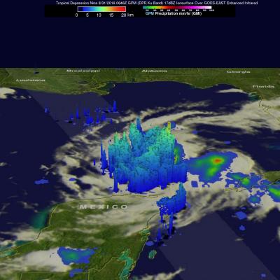
GPM Sees Increasingly Organized Tropical Storm Hermine

Tropical Depression Nine was upgraded to Tropical Storm Hermine on Wednesday August 31, 2016 at 2 PM EDT (1800 UTC). The GPM core observatory satellite passed directly above newly designated tropical storm Hermine on August 31, 2016 at 4:06 PM EDT (20:06 UTC). Rainfall data derived from GPM's Microwave (GMI) and Dual-Frequency Precipitation Radar (DPR) instruments showed that precipitation intensity had increased and moved into western Florida. Rainfall measured by GPM's DPR had increased to a rate of over 9.9 inches (251 mm) per hour in very powerful storms in the Gulf Of Mexico northwest of

Intensifying Tropical Depression Nine Checked By GPM

The National Hurricane Center (NHC) expects Tropical Depression Nine to intensify over the next day or so. Vertical wind shear is predicted to be low and the tropical depression is moving over warmer water. Both of these factors will provide fuel for intensification. The GPM core observatory satellite scanned the tropical depression on August 31, 2016 at 2:46 AM EDT (0646 UTC). GPM's Microwave Imager (GMI) and Dual-Frequency Precipitation Radar (DPR) instruments saw heavy rainfall in strong convective storms in the Gulf Of Mexico northwest of Cuba. GPM's DPR found that some of these intense

GPM Views Hurricane Gaston Eye Wall Replacement

Hurricane Gaston was located in the central Atlantic Ocean west of Bermuda when the GPM core observatory satellite passed over on August 30, 2016 at 00:31 AM EDT (0431 UTC). Gaston was a category two on the Saffir-Simpson hurricane wind scale with maximum sustained winds of about 103.5 mph (90 kts). GPM happened to fly over as Gaston was undergoing an eye wall replacement. Intense rainfall was clearly shown by GPM in rain bands of both the inner and the outer replacement eye walls. Precipitation was calculated from data collected by GPM's Microwave Imager (GMI) and Dual-Frequency Precipitation

Tropical Depression Nine Forms

The frequency of tropical cyclone formation has definitely increased in the Atlantic Ocean basin. A tropical wave that the National Hurricane Center (NHC) had been monitoring for development since it left the African coast almost two weeks ago was upgraded to Tropical Depression Nine (TD09L) on August 28, 2016. The low pressure became a little better organized after moving into the Florida Strait and that led to the upgrade. The GPM core observatory satellite passed above the still relatively poorly organized tropical depression on August 29, 2016 at 2:56 AM EDT (0656 UTC). Maximum sustained

GPM Examines Tropical Storm Lester

Lester became the 12rd named storm of the 2016 eastern Pacific Ocean hurricane today. Lester was far away from the Mexican coast early today and headed toward the west-northwest. Low vertical wind shear and warm sea surface temperatures are expected to assist Lester's intensification to hurricane status tomorrow. Tropical storm Lester had wind speeds of about 35 kts (40 mph) when the GPM core observatory satellite passed over on August 25, 2016 at 1026 UTC. Data from GPM satellite's Microwave Imager (GMI) and Dual-Frequency Precipitation Radar (DPR) instruments showed that Lester was getting