Extreme Weather News

Jump to a Year

2024 | 2023 | 2022 | 2021 | 2020

2019 | 2018 | 2017 | 2016 | 2015

2014 | 2013 | 2012 | 2011 | 2010

2009 | 2008 | 2007 | 2006 | 2005

2004 | 2003 | 2002

GPM Sights Another Forming Tropical Cyclone

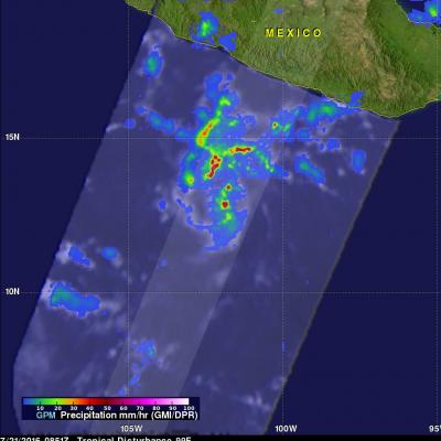
The eastern Pacific Ocean continues to spawn tropical cyclones. Seven named tropical cyclones have already formed in the Eastern Pacific ocean this year. The National Hurricane Center (NHC) has indicated that another tropical cyclone is likely to form in a broad area of low pressure southwest of Acapulco, Mexico. The GPM core observatory satellite flew directly above this increasingly organized stormy area on July 21, 2016 at 0851Z. GPM found that powerful thunderstorms in that area contained intense showers. Rain was measured by GPM's Dual-Frequency Precipitation Radar (DPR) instrument

GPM Used To Evaluate Tropical Storm Estelle

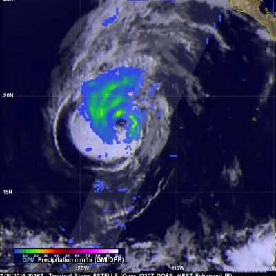
The GPM core observatory satellite traveled above tropical storm Estelle on July 19, 2016 at 1036 UTC. This pass showed that Estelle contained well organized convective bands that were producing precipitation within the storm. Precipitation within Estelle was analyzed using data collected by GPM's Microwave Imager (GMI) and Dual-Frequency Precipitation Radar (DPR) instruments. GPM's radar (DPR Ku band) data were used to perform a 3-D examination of the precipitation on the eastern side of tropical storm Estelle. Some rainfall was measured by DPR falling at a rate of over 65 mm (2.6 inches) per

Southern Hemisphere Tropical Cyclone Abela Viewed By GPM

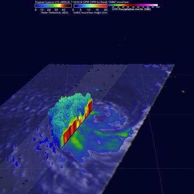
Tropical cyclone 01S (Abela) formed in the South Indian Ocean on July 16, 2016. Abela was the first tropical Cyclone to form in July over the South Indian Ocean since 2007 so it is a little unusual. The GPM core observatory satellite recently had two good views of Abela. GPM saw the newly formed tropical cyclone on Jul 16, 2016 at 2216 UTC. Precipitation data collected by GPM's Microwave Imager (GMI) and Dual-Frequency Precipitation Radar (DPR) instruments showed that ABELA contained a large area of rainfall on July 16, 2016. Then again on July 18, 2016 at 2206 the satellite passed above after

GPM Sees Tropical Depression SIX-E Forming

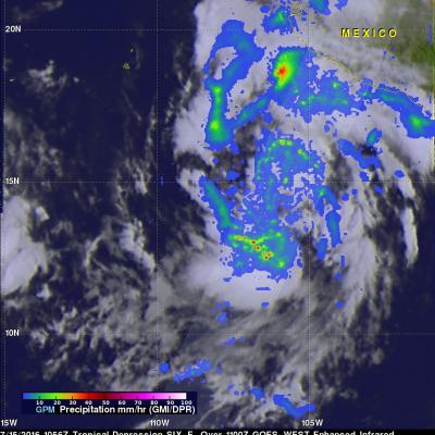
A large area of low pressure in the eastern Pacific Ocean was sufficiently organized and developed that the National Hurricane Center (NHC) designated it as tropical depression SIX-E on July 15, 2016 at 1500Z (9:00 AM MDT). With the development of tropical depression SIX-E there are currently three active tropical systems in the eastern Pacific Ocean. The GPM core observatory had a good view of forming tropical depression SIX-E when it flew over on July 15, 2016 at 1056 UTC (4:56 AM MDT). Precipitation data were calculated from data collected by GPM's Microwave Imager (GMI) and Dual-Frequency

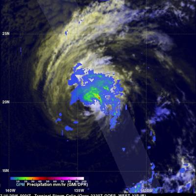
Rainfall Measured By GPM In Weakening Tropical Storm Celia

Celia was a powerful hurricane with winds of 85 kts (98 mph) a couple days ago but has recently been moving over cooler ocean waters that are contributing to a weakening trend. Hurricane Celia had weakened to a tropical storm with winds of about 45 kts (52 mph) when the GPM core observatory satellite flew over on July 14, 2016 at 0001 UTC. GPM found that convective storms were mainly located to the north and northeast of Celia's center of circulation. GPM's Microwave Imager (GMI) and Dual-Frequency Precipitation Radar (DPR) found that rain was falling at over 164 mm (6.4 inches) per hour