Extreme Weather News

Jump to a Year

2024 | 2023 | 2022 | 2021 | 2020

2019 | 2018 | 2017 | 2016 | 2015

2014 | 2013 | 2012 | 2011 | 2010

2009 | 2008 | 2007 | 2006 | 2005

2004 | 2003 | 2002

GPM Observes Tropical Storm Gaston's Development

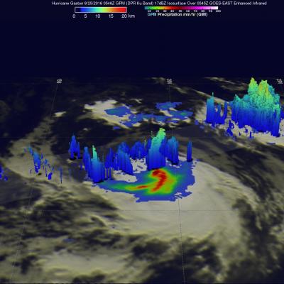
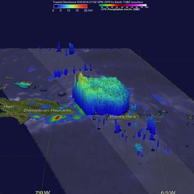
Tropical storm Gaston became the 7th named tropical storm in the Atlantic Ocean after forming southwest of the Cape Verde Islands on Monday evening August 22, 2016. Gaston's development followed closely behind tropical storm Fiona that formed in the same area southwest of the Cape Verde Islands on August 17, 2016. Fiona is now fading quickly in the Atlantic Ocean southwest of Bermuda. Tropical storm Gaston is predicted by the National Hurricane Center (NHC) to intensify and become a hurricane on August 24, 2016. Gaston is expected to move into the center of the Atlantic Ocean well east of

Increased Western Pacific Tropical Cyclone Activity Seen By GPM

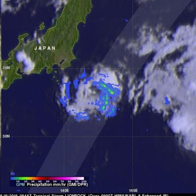
The first typhoon in the western Pacific Ocean (NEPARTAK) didn't form until July this year. Since then tropical cyclone activity has increased with four of the named tropical cyclones coming near Japan. Typhoon Chantu recently brought strong winds and heavy rain to northern Japan. Tropical storm Lionrock quickly followed Chantu and is predicted to strengthen little while moving past to the south of Japan. Another tropical storm called Mindulle formed today in the Pacific Ocean northwest of Guam. Mindulle is predicted to move northward, intensify and become a typhoon just before hitting

GPM Satellite Sees Forming Atlantic Tropical Depression

Tropical Depression Six (TD06L) formed in the Eastern Atlantic Ocean southwest of the Cape Verde Islands late Tuesday evening. TD06L has become better organized today. The National Hurricane Center (NHC) predicts that the tropical depression will intensify and become tropical storm Fiona later today. The tropical storm is predicted to become slightly more powerful while moving toward the northwest over the open waters of the central Atlantic. The GPM core observatory satellite collected data when TD06L was forming on August 16, 2016 at 2031 UTC. GPM data showed that the forming tropical

Deadly Flooding Gulf Coast Rainfall Measured By NASA's IMERG

An extremely severe rainfall event hit the states of Louisiana and southern Mississippi when a very slow moving low pressure system continuously pulled tropical moisture from the Gulf Of Mexico. Measurements by the GPM core observatory satellite showed that rainfall intensity within the low pressure system actually increased on August 12, 2016 as the low settled over southeastern Louisiana. At least 4 people have died in record flooding after the unusually heavy rainfall starting falling last week. More than 27 inches (686 mm) of rain have been reported in the area. This is the second time

Extreme Rainfall Along the Gulf Coast Measured by IMERG

For the better part of a week, a persistent, mid-level area of low pressure has been tapping into warm, moist air to produce stormy weather in the northeastern Gulf Of Mexico. The National Hurricane Center (NHC) monitored this stormy area for possible development but unfavorable upper-level winds and the close proximity to land prevented development into a tropical system. However, during the past week from as much as 4 to over 15 inches (254-381 mm) of rain fell along the Gulf Coast from Tampa northward through the Big Bend to as far west as central Louisiana. So far the highest rainfall