Rapidly Intensifying Typhoon Examined By GPM
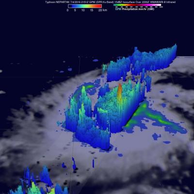
The first typhoon of 2016 called Nepartak developed in the western Pacific Ocean on July 3, 2016 south of Guam. Nepartak has moved to the west-northwest of Guam and has started to rapidly intensify. Warm water, low vertical wind shear and favorable outflow due an upper level trough are providing favorable environmental conditions for the typhoon. The GPM core observatory satellite flew above Nepartak on July 4, 2016 at 2151 UTC when the tropical cyclone was still classified as a tropical storm. GPM's Microwave Imager (GMI) and Dual-Frequency Precipitation Radar (DPR) data showed that Nepartak