Extreme Weather News

Jump to a Year

2024 | 2023 | 2022 | 2021 | 2020

2019 | 2018 | 2017 | 2016 | 2015

2014 | 2013 | 2012 | 2011 | 2010

2009 | 2008 | 2007 | 2006 | 2005

2004 | 2003 | 2002

Developing Tropical Storm Triggers Deadly Landslides in Sri Lanka

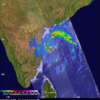
A storm does not have to be especially powerful in terms of its winds to be deadly. Such is the case with Tropical Cyclone 01B (TC 01B) in the Bay of Bengal. Despite only reaching minimal tropical storm intensity just this morning at 06 UTC 18 May 2016, the system has been responsible for dumping heavy rains in and around Sri Lanka and southern Indian over the past few days as it tried to organize itself in the southwestern Bay of Bengal. This set the stage for two massive landslides, which buried 3 villages in south central Sri Lanka. So far, although several hundred people have been rescued

GPM Measures Deadly Flooding Rainfall

Over the past week extreme rainfall caused flooding that resulted in the deaths of four in Haiti and the evacuation of over 2500 people in the Dominican Republic. The GPM core observatory satellite saw a line of heavy rainfall on the eastern side of the Dominican Republic when it flew over on May 8, 2016 at 0428 UTC. GPM's Microwave Imager (GMI) and Dual-Frequency Precipitation Radar (DPR) instruments collected data that were used to estimate rainfall. This precipitation is shown on a top-down satellite view. Powerful storms were measured dropping rain at a rate of almost 300 mm (11.8 inches)

Severe Weather In Tornado Alley And Eastward (May 2nd Update)

Severe spring thunderstorms frequently spawned tornadoes from the Gulf Coast north and eastward during the past seven days. From April 25 to May 2, 2016 there were over 67 tornadoes in the United States reported to the National Oceanic and Atmospheric Administration (NOAA). Many of these tornadoes were located in an area that includes the states of Texas, Oklahoma, Kansas, and Nebraska. This area of the Great Plains has been labeled Tornado Alley due to the many tornadoes that occur there this time of year. Gulf moisture clashing with frontal systems moving over the United States provided much

Severe Weather In Tornado Alley And Eastward

Severe spring thunderstorms frequently spawned tornadoes from the Gulf Coast north and eastward during the past week. Gulf moisture clashing with frontal systems moving over the United States provided much of the fuel for intense showers and severe thunderstorms. Flash flooding was often the result of the sudden onset of extremely heavy rainfall. Over 305 mm (12 inches) of rain was reported in southern Mississippi in a few hours one morning on April 28, 2016. NASA's Integrated Multi-satellitE Retrievals for GPM (IMERG) data were used to estimate the amount of rain that fell from April 22-29

Tropical Cyclone Fantala's Changes Observed By GPM

As expected, tropical cyclone Fantala reversed course and moved southeastward almost directly over it's earlier track. The tropical cyclone's intensity also fluctuated. Maximum winds dropped significantly as Fantala moved southeastward but have rebounded somewhat today. The GPM core observatory satellite flew over the tropical cyclone on April 19, 2016 at 1346Z when winds had dropped to about 95 kts (109 mph). At that time GPM's Microwave Imager (GMI) and Dual-Frequency Precipitation Radar (DPR) found that Fantala still contained extremely heavy rainfall in storms spiraling into the tropical