Extreme Weather News

Jump to a Year

2024 | 2023 | 2022 | 2021 | 2020

2019 | 2018 | 2017 | 2016 | 2015

2014 | 2013 | 2012 | 2011 | 2010

2009 | 2008 | 2007 | 2006 | 2005

2004 | 2003 | 2002

GPM See Potential Tropical Cyclone

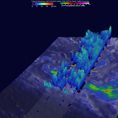
The GPM core observatory satellite flew over an area of disturbed weather in the South Pacific near Bora Bora early today where a tropical cyclone may be forming. On February 29, 2016 at 0456 UTC GPM's Microwave Imager (GMI) saw rain falling at an estimated rate of almost 48 mm (1.9 inches) per hour in an area of deep convection south of a tropical low. GPM's Dual-frequency Precipitation Radar (DPR) instrument measured cloud top heights at an altitude of over 10.5 km (6.5 miles) in rain showers between Bora Bora and Tahiti.

Tropical Cyclone Winston Hits Fiji

The GPM core observatory satellite flew directly above tropical cyclone Winston on February 20, 2016 at 0941 UTC. Tropical cyclone Winston had sustained winds estimated at 155 kts (178 mph) at that time. A rainfall analysis derived from data collected by GPM's Microwave Imager (GMI) and Dual-frequency Precipitation Radar (DPR) instruments found that in addition to powerful winds Winston was dropping rain at a rate of over 169 mm (6.7 inches) per hour in the western side of the eye. Tropical cyclone WINSTON is the most powerful storm to hit Fiji. At least one fatality has already occurred. The

GPM Again Examines Powerful Tropical Cyclone Uriah

Both yesterday and today the GPM core observatory satellite had excellent views of tropical cyclone Uriah in the South Indian Ocean. Uriah was intensifying with winds of about 115 kts (132 mph) on February 17, 2016 at 1651 UTC when the GPM satellite passed above. A rainfall analysis derived from GPM's Microwave Imager (GMI) and Dual-frequency Precipitation Radar (DPR) data collected with that pass revealed that Uriah had a well defined circular eye. Rain was measured by DPR falling at a rate of over 179 mm (7 inches) per hour on the southern side of Uriah's eye wall. GPM passed over again on

GPM Examines Tropical Cyclone Uriah

Over the past view days the GPM core observatory satellite has had good looks at tropical cyclone URIAH in the South Indian Ocean west of Australia. On February 15, 2016 at 1706 UTC GPM flew directly over the center of the tropical cyclone and measured rainfall in a well defined circulation. GPM's Dual-frequency Precipitation Radar (DPR) instrument discovered that rain was falling at a rate of over 127 mm (5 inches) per hour in a band of intense storms south of the cyclone's center. When GPM's Radar sliced through tropical storm URIAH on February 15, 2016 it also found that the intense

Intensifying South Pacific Tropical Cyclone Winston Viewed By GPM

Tropical cyclone activity has recently increased in the South Pacific Ocean. Four tropical cyclones have formed in this area in 2016. The GPM core observatory satellite had an excellent view of tropical cyclone Winston on February 11, 2016 at 1253 UTC. Winston was located east of Vanuatu with tropical storm force winds of about 55 kts when GPM passed over head. Winston's rainfall was measured by GPM's Microwave Imager (GMI) and Dual-frequency Precipitation Radar (DPR) instruments. GPM's radar data revealed that Winston was dropping rain at a rate of over 60 mm (2.4 inches) per hour on the