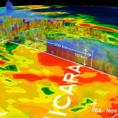
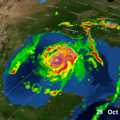
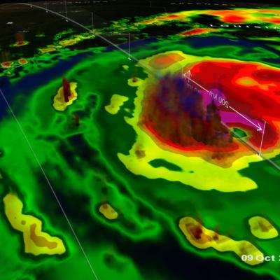
Typhoon IN-FA's Extreme Rainfall Measured By GPM

Typhoon IN-FA's peaked as a category four tropical cyclone on the Saffir-Simpson scale with maximum sustained winds of about 115 kts (132 mph) on November 21, 2015. IN-FA's winds had decreased to about 90 kts (103.5 mph) when the GPM core observatory satellite flew over on November 23, 2015 at 1555 UTC. Measurements by GPM's Dual-Frequency Precipitation Radar (DPR) instrument indicated that IN-FA was dropping rain at an extreme rate of over 266 mm (10.5 inches) per hour in storms just to the northwest of the typhoon's eye. GPM's radar (DPR Ku Band) were used to show the 3-D structure of

Tropical Storm Rick Examined By GPM

Tropical storm Rick is the latest tropical cyclone to form in the 2015 Eastern Pacific Ocean hurricane season which has spawned a record number of dangerous hurricanes. Tropical storm Rick was moving over the eastern Pacific Ocean well off the Mexican coast when the GPM core Observatory satellite flew over on November 19, 2015 at 1956 UTC. Data captured by GPM's Microwave Imager (GMI) and Dual-Frequency Precipitation Radar (DPR) show that tropical storm Rick had a couple areas near the center of circulation that were dropping rain at a rate of over 41.6 mm (1.6 inches) per hour. GPM's radar

GPM Sees Better Organized Typhoon IN-FA

The GPM core observatory satellite had another excellent view of typhoon IN-FA on November 19, 2015 at 0305 UTC. This GPM pass revealed the location of typhoon IN-FA's eye beneath dense overcast. Rainfall derived from data collected by GPM's Microwave Imager (GMI) and Dual-Frequency Precipitation Radar (DPR) instruments show that feeder bands around IN-FA were getting better organized. The most intense precipitation was measured in IN-FA's eye wall by DPR where it was falling at a rate of almost 55 mm (2.16 inches) per hour. Most rainfall in feeder bands was shown by GPM to be only light to

Positional Algorithm Issue with GMI 85GHz

One of our scientists noticed that the 85GHz H and V channels have missing values in ascending passes just south of 20 deg S. In that region it appears consistently since 10:45UTC which is the earliest we checked. The other channels seem fine. The counts for the 85GHz channels appear to be fine as is the geolocation. However both the 1B and 1 Base files have the missing values in that area. We are checking what is causing the algorithm to list the values as missing. Please keep this in mind when using those channels.