Weather

Earth’s climate is changing. The accumulation of greenhouse gases has affected the oceans and ice systems as well as the atmosphere, which in turn impacts the water cycle. To predict future changes in weather and climate and estimate environmental variables, scientists use sophisticated computer models. These models rely on available global data to describe the conditions that exist today to project how conditions may change in the future. GPM’s Weather, Climate, and Land Surface Modeling Applications area promotes the use of precipitation measurements from GPM satellites to help model future behavior of precipitation patterns and climate. 

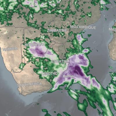
IMERG rainfall totals in South Africa, April 5 - 18, 2022.
An upper-level area of low pressure tapped into the warm waters of the South Indian Ocean to bring heavy rains and flooding to parts of South Africa during the second week of April. The event unfolded when an upper-level trough of low pressure embedded within the midlatitude westerlies traversed the southern part of Africa from west to east. As the trough approached the east coast of South Africa, an area of low pressure became detached from the main flow, this “cut off” low then drifted over the warm waters of the Agulhas Current, which channels warmer waters from the tropical Indian Ocean
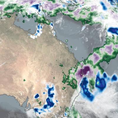
IMERG Rainfall Totals from Australian :"Rain Bomb" in March 2022
The below animation shows surface rainfall estimates from NASA’s IMERG multi-satellite precipitation product for the week starting on Feb. 22, 2022 at 0000 UTC and ending on Feb. 28, 2022 at 2330 UTC. Areas shaded in blue and yellow show three-hour average snapshots of IMERG rain rates every half-hour overlaid on cloudiness (shown in white/gray) based on geosynchronous satellite infrared observations. Below the rain rates and cloudiness data, IMERG rainfall accumulations are shown in green and purple. Tropical Cyclone Anika’s track is shown with a gray line based on data from the U.S. Navy-Air
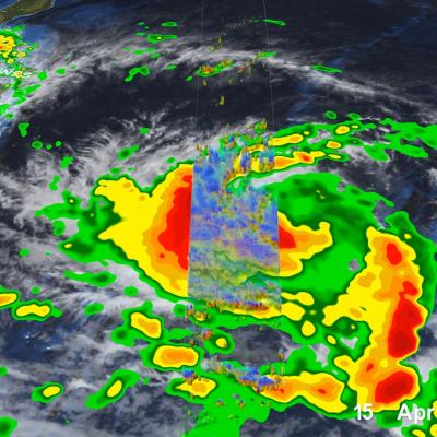
GPM Overpass of Typhoon Surigae
Although it was only the 2nd named storm of the 2021 Pacific typhoon season, Typhoon Surigae became not only the first super typhoon of the season, but also the strongest tropical cyclone of 2021 worldwide. The majority of storms in the Northwest Pacific region form between June and Nov., but the season runs yearlong, as storms can form in any month in this region, which stretches from 100 degrees East to 180 degrees East, north of the equator. Surigae originated from an area of low pressure about 700 miles south of Guam. Persistent thunderstorm activity resulted in the formation of a tropical
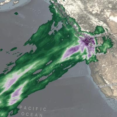
IMERG rainfall totals from the Nov. 2021 atmospheric river.
The Pacific Northwest coast saw two atmospheric rivers (ARs) bring heavy rains from Nov. 10-16, 2021, resulting in severe flooding, landslides, and damage to infrastructure in the British Columbia province of Canada. ARs are long, narrow corridors of water vapor that travel vast distances above the ocean from warm, tropical regions to higher latitudes, where they often release their moisture as rainfall when they reach land areas. While ARs occur across the globe, this year has been notable for several strong events that have impacted the Pacific Northwest coast. The two atmospheric rivers in
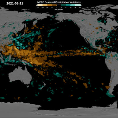
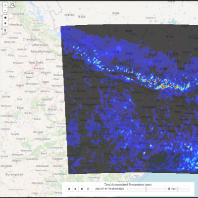
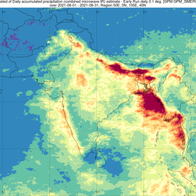
2021 average daily rainfall June, July August.
The Indian summer monsoon, also known as the southwest monsoon, falls within the South Asian monsoon and is the strongest and perhaps best-known of the world’s monsoons. During summer months when the Asian landmass heats up, warm, moist air flows northward from the Indian Ocean towards the Himalayas, bringing abundant showers and thundershowers to India. The summer monsoon is a regular event that occurs every year and is responsible for roughly 80% of India’s annual rainfall. The summer monsoon typically starts in early June, peaks in July and August and winds down during September and early
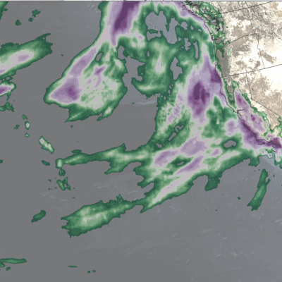
IMERG rainfall totals from recent atmospheric river.
The Pacific Northwest experienced a memorable series of storms in late Oct. 2021 as several low-pressure systems rolled in from the northeast Pacific Ocean. One of the systems was classified by meteorologists as a “bomb cyclone”, meaning that its central pressure (an indication of storm strength) had dropped particularly rapidly in a short time period. At its minimum pressure (highest strength), the system was reported by the National Weather Service to have had the lowest pressure of a system over the northeastern Pacific Ocean since reliable observations began in 1974. The system was notable
Hurricane Ida IMERG Totals
All eyes were on Hurricane Ida as it made landfall in Louisiana on Aug. 29, 2021, but many people were taken by surprise by the power of Hurricane Ida's remnants when they reached Virginia during the day on Sept.1 and New York City late at night on Sept. 1 into early morning on Sept. 2. The below animation shows the precipitation that fell during the entire lifecycle of Ida from before landfall in Louisiana through the impacts on New York City. Download this video (right-click -> "Save As") This animation uses data from the near real-time version of NASA's IMERG algorithm, a data product that
IMERG Precipitation Anomalies
Climate change impacts all of us in various ways. Changes in soil moisture have a pronounced effect on agricultural production, which in turn impacts the food we grow to eat. Changes in precipitation patterns are leading to increases in drought in certain regions and causing flooding in others. All of these impacts are influenced by interactions among processes within the Earth system involving the atmosphere, ocean, land, ice, and life. These natural interactions, combined with human influences such as the release of greenhouse gases, serve to drive the climate system resulting in distinct
GOES Model of Earth's Climate
Climate researchers around the world are taking advantage of NASA satellite observations to help inform, improve, and enhance climate models. NASA data helps to predict the future of Earth's climate and improve the predictive capability of models. This gives decision-makers the tools they need to make better decisions on how we live, including understand the changing impacts of hurricanes and improving predictions of fire seasons. But how exactly does NASA data support climate modeling activities, and how does the data improve these models? We’re here to explain the inner workings of how NASA
GPM Overpass of Tropical Cyclone Fred on August 16, 2021.
Tropical Storm Fred, the 6th named storm of the 2021 Atlantic hurricane season, began as a westward moving disturbance in the central Atlantic east of the Lesser Antilles. The system passed through the southern Leeward Islands during the early morning hours of August 10 but still lacked a well-defined center of circulation. Despite significant thunderstorm activity within the system, it wasn’t until late that evening, when the system was passing just south of Puerto Rico, that the National Hurricane Center (NHC) identified a well-defined circulation and upgraded the system to Tropical Storm