Weather

Earth’s climate is changing. The accumulation of greenhouse gases has affected the oceans and ice systems as well as the atmosphere, which in turn impacts the water cycle. To predict future changes in weather and climate and estimate environmental variables, scientists use sophisticated computer models. These models rely on available global data to describe the conditions that exist today to project how conditions may change in the future. GPM’s Weather, Climate, and Land Surface Modeling Applications area promotes the use of precipitation measurements from GPM satellites to help model future behavior of precipitation patterns and climate. 

IMERG Rainfall Totals from Medicane Ianos
From September 14th - 20th, 2020, NASA’s IMERG algorithm estimated the rainfall from a Mediterranean cyclone with tropical-like characteristics, commonly known as a “Medicane”, which flooded parts of Greece. Medicanes typically appear once or twice a year and are similar to tropical storms in that both have a symmetric structure, a warm core, a clearly visible eye, and winds of at least tropical-storm strength. This particular storm system, dubbed "Ianos" by the National Observatory of Athens, led to media reports of flooding throughout the islands of Kefalonia and Zakynthos off the western
IMERG totals from hurricane sally
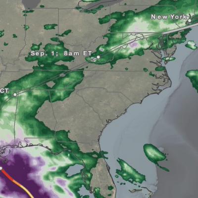
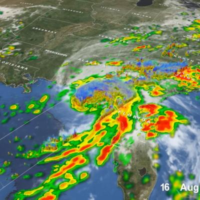
The northern Gulf Coast has seen its share of storms this busy hurricane season. At the end of August, then Tropical Storm Marco brought heavy rains to parts of the Florida Panhandle while western Louisiana took a direct hit from the much more powerful Category 4 Hurricane Laura. Now, just over 3 weeks since Laura made landfall, the northern Gulf Coast was struck again, this time by Hurricane Sally. Though not as powerful as Laura, the still rather strong Sally behaved more like Marco. But, while Marco was largely sheared apart with most of the rain well northeast of the center as it slowed
IMERG Rainfall from Typhoons Bavi, Maysak and Haishen
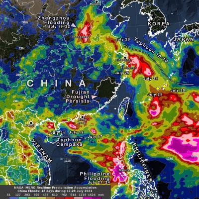
From August 22 through September 7, 2020, NASA’s IMERG algorithm estimated rainfall from three typhoons as they passed over the Pacific Ocean, Japan, and Korea. According to NOAA's records, this was the only time since records have been kept starting in 1945 that the Korean peninsula saw three landfalling typhoons in a single year, let alone in two weeks. Each of the three typhoons--Bavi, Maysak, and Haishen--reached the equivalent of “major hurricane” status, meaning Category 3 or above on the Saffir-Simpson hurricane-intensity scale (shown here as a red in the hurricane track) along their
IMERG rainfall from the Pakistan Floods 2020
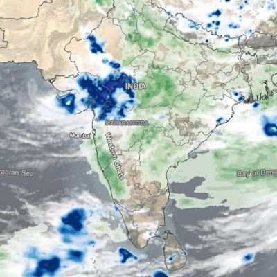
In the last week of August 2020, Pakistan's largest city, Karachi, received over 8 inches of rainfall according to NASA's IMERG dataset, causing destructive flooding in the region. The amount of rain that fell that week is roughly equivalent to the amount that Karachi typically receives in an entire year, based on IMERG's 19-year global climatology. In a typical year, most of Karachi's rain will fall in July and August, but the rainfall during the week of August 23rd was unusually heavy. The top panel of the three panels in this image shows the depth of the 7-day rainfall accumulation in
IMERG Rainfall Totals from Hurricanes Marco and Laura
The northern Gulf Coast, specifically Louisiana, saw two tropical cyclones make landfall in the same week just days apart. The two systems, however, could not have been more different when they arrived. Despite forming a day later, Marco was the first system to make landfall on the Gulf Coast. Marco originated from a tropical easterly wave that was moving from the central to the western Caribbean. After becoming a tropical depression (TD) on the 20th of August, TD #14 turned northwestward the following day as it approached the coast of Central America and moved into the northwest Caribbean
GPM Overpass of Hurricane Laura 8/27/20
After crossing western Cuba, Tropical Storm Laura emerged into the Gulf of Mexico where warm water, low wind shear and a moist environment made conditions ideal for intensification. As it made its way through the Gulf of Mexico Laura strengthened - from a category 1 hurricane with sustained winds of 75 mph on the morning of Tuesday August 25th, to a powerful category 4 storm, with sustained winds of 150 mph on the evening of Wednesday August 26th - an increase of 75 mph in just 36 hours. At this point Laura was nearing the coast of western Louisiana, and made landfall near Cameron, Louisiana
GPM Overpass of Hurricane Laura 8/26/20 10:00pm CT
Hurricane Laura began as a tropical depression on August 21st near the U.S. Virgin Islands, and over the next several days rapidly intensified to a dangerous category 4 hurricane at it moved towards the U.S. Gulf Coast. Laura made landfall as strong category 4 hurricane near Cameron, Louisiana shortly after midnight on August 27, 2020, bringing extreme rainfall, storm surge, and winds up to 150 mph. The NASA / JAXA GPM Core Observatory satellite flew over Hurricane Laura shortly before it made landfall at 10:00pm CT on Wednesday, August 26th, then again at 7:42am CT on Thursday, August 27th
Hurricane Laura on August 27, 2020
Update on August 28, 2020: During its approach to Louisiana, Hurricane Laura dramatically intensified from Category 2 to 4 (105 mph to 150 mph) between at 1AM and 7PM Central Time (CDT) on August 26, 2020. In the updated movie below, the precipitation falling from Laura is shown through 10:30PM CDT, August 27, as estimated by NASA's IMERG algorithm. To open the animation in a separate window, click here . On August 26, Laura became the first North Atlantic hurricane to reach "major hurricane" status this year, meaning that it reached category 3 on the Saffir-Simpson hurricane-intensity scale
Hurricane Isaias Impacts the US East Coast
From July 29 to August 5, 2020, NASA’s IMERG algorithm observed tropical storm Isaias’ rainfall over the Caribbean and large parts of the Eastern US. This animation shows the IMERG rain rates in green shading as Isaias tracked from the tropical Atlantic into the Caribbean, then northward along the Atlantic coast and into New England. The yellow line shows the location of Isaias' low-pressure center, as tracked by the National Hurricane Center and smoothed in time here for the animation.
IMERG Hurricane Hanna 7-27-20 cropped
Hanna formed from a westward propagating tropical easterly wave that entered the southeast corner of the Gulf of Mexico on Tuesday July 21st. The wave provided a focus for shower and thunderstorm activity, which then led to the formation of an area of low pressure over the central Gulf of Mexico. The National Hurricane Center (NHC) found that this low had developed a closed circulation by the evening of Wednesday July 22nd, making it Tropical Depression #8. Over the next 24 hours, the depression slowly organized and intensified over the central Gulf before reaching tropical storm intensity on