Extreme Weather News

Jump to a Year

2024 | 2023 | 2022 | 2021 | 2020

2019 | 2018 | 2017 | 2016 | 2015

2014 | 2013 | 2012 | 2011 | 2010

2009 | 2008 | 2007 | 2006 | 2005

2004 | 2003 | 2002

GPM Sees New Tropical Storm Harvey

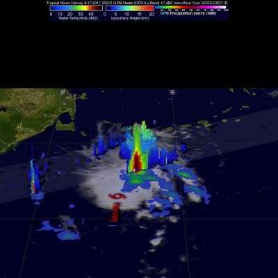
The National Hurricane Center (NHC) upgraded a tropical disturbance that they were monitoring east of the Lesser Antilles to Tropical storm Harvey on August 17, 2017 at 5:00 PM EDT (2100 UTC). The GPM core observatory satellite flew over newly designated tropical storm Harvey on August 17, 2017 at 6:21 PM EDT (2221 UTC). Easterly vertical wind shear was causing the strongest convection to be pushed to the west of the tropical storm's center of circulation. GPM's Microwave Imager and Dual-Frequency Precipitation Radar (DPR) found that some of these strong convective storms were dropping very

Potential Tropical Cyclone Nine Viewed By GPM

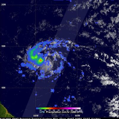
On Thursday August 17, 2017 at 1100 AM AST (1500 UTC) the National Hurricane Center (NHC) called a stormy area of low pressure east of the Antilles "Potential Tropical Cyclone Nine". The GPM core observatory satellite flew above this area of disturbed weather earlier at 6:58 AM AST (1058 UTC). GPM's Microwave Imager (GMI) and Dual-Frequency Precipitation Radar (DPR) data were used to examine the coverage and intensity of rainfall around the potential tropical cyclone. The center of the heaviest rainfall was located in GPM's GMI swath. Rain in that area was found by GMI to be falling at a rate

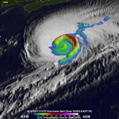
GPM Examines Hurricane Gert's Rainfall

The GPM core observatory satellite provided rainfall information about hurricane Gert on August 16, 2017 at 5:37 PM EDT (2137 UTC). At that time Gert was a strong category two hurricane with maximum sustained winds of about 93.5 mph (85 kts). Data from GPM's Microwave Imager (GMI) instrument showed that rain was still falling at a rate of more than 2.94 inches (74.7 mm) per hour in a powerful band of storms spiraling around Gert's eastern side. With that pass GPM's Dual-Frequency Precipitation Radar (DPR) had a limited encounter with hurricane Gert. DPR did find that rain in storms on the

Deadly Southern Asia Flooding Rainfall Measured By NASA's IMERG

Deaths of over 250 people have resulted from extremely heavy monsoon rainfall in parts of northern India, Bangladesh and Nepal. The death toll from flooding and landslides is expected to continue increasing. Heavy monsoon rainfall is normal in southern Asia this time of year but precipitation totals this year are higher than expected. Recent heavy rainfall is also causing the Brahmaputra and Ganges Rivers rivers to continue rising. This rainfall analysis over southern Asia was created using IMERG real time data covering the period from August 10-16, 2017. Total rainfall IMERG estimates of over

GPM Sees Gert Approaching Hurricane Intensity

Tropical storm Gert was upgraded to a Hurricane on 1100 PM EDT Monday August 14, 2017 at 11:00 PM (August 15, 2017 0300 UTC). The GPM core observatory satellite flew over the intensifying tropical storm on August 14, 2017 at 7:21 PM EDT (2321 UTC). With winds of about 69 mph (60 kts) Gert was getting close to hurricane intensity. Data collected by GPM's Microwave Imager (GMI) and Dual-Frequency Precipitation Radar (DPR) instruments showed heavy rainfall south of Gert's partial eye. GMI showed that rain was falling at a rate of over 1.6 inches (40 mm) in that area. GPM's Radar scanned through