Extreme Weather News

Jump to a Year

2024 | 2023 | 2022 | 2021 | 2020

2019 | 2018 | 2017 | 2016 | 2015

2014 | 2013 | 2012 | 2011 | 2010

2009 | 2008 | 2007 | 2006 | 2005

2004 | 2003 | 2002

Rainfall In Southeast Asia Analyzed By GPM

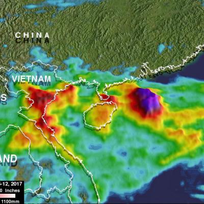
Tropical storm Khanun formed northeast of the Philippines on October 12, 2017. The GPM core observatory satellite passed above Khanun on October 13, 2017 (0656 UTC) when maximum sustained wind speeds had reached about 45 kts (~52 mph). Khanun had passed over the northern Philippines and was moving into the South China Sea. The approximate location of Khanun's center of circulation is shown with a red tropical storm symbol. The intensifying tropical storm's rainfall is shown in this image courtesy of data collected by GPM's Microwave Imager (GMI) and Dual-Frequency Precipitation Radar (DPR)

Strengthening Tropical Storm Ophelia Observed By GPM

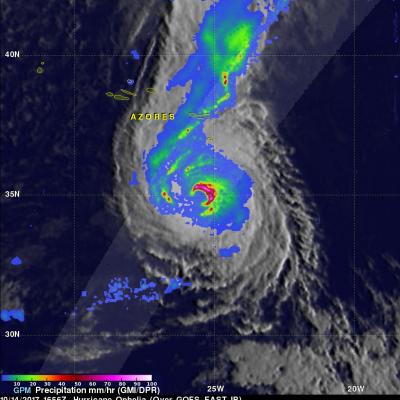
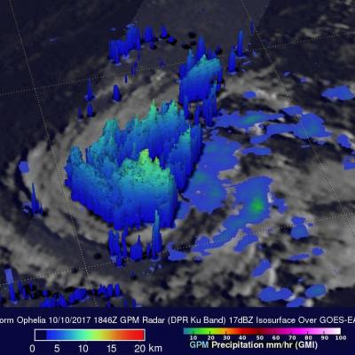
On Monday October 9, 2017 at 1100 AM AST (1500 UTC) tropical depression seventeen (TD17) was upgraded to tropical storm Ophelia. The tropical storm is located over the open waters of the the eastern Atlantic southwest of the Azores. The GPM core observatory satellite had a good view of tropical storm Ophelia on October 10, 2017 at 2:46 PM AST (1846 UTC). GPM's Microwave Imager (GMI) and Dual-Frequency Precipitation Radar (DPR) revealed that the storm was organized but most of the rainfall in the storm was only of light to moderate intensity. The area covered by GPM's 151.9 mile wide (245 km)

GPM Sees Powerful Thunderstorms In Landfalling Hurricane Nate

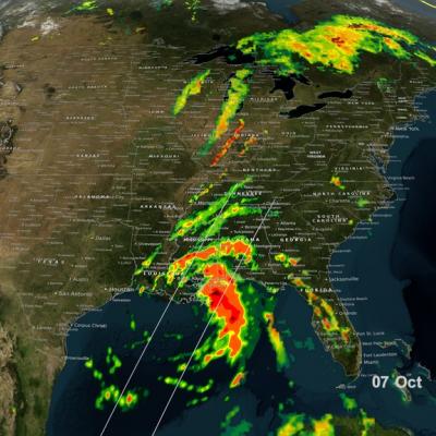
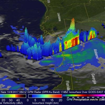
The GPM core observatory satellite passed above powerful thunderstorms within land falling hurricane Nate on October 8, 2017 at 4:41 AM EDT (0841 UTC). GPM's Dual-Frequency Precipitation Radar (DPR) found that a few storms over southwestern Alabama were dropping rain at the extreme rate of greater than 4 inches (102 mm) per hour. This 3-D slice by GPM's radar (DPR Ku Band) shows the structure of precipitation within the powerful thunderstorms near the center of hurricane Nate. A few thunderstorms over Alabama were found by GPM's radar to have tops reaching heights above 10.5 miles (17 km).

GPM Examines Forming Tropical Storm Nate (TD16)

The GPM core observatory satellite passed above forming tropical storm Nate (TD16) on October 5, 2017 at 5:46 AM EDT (0946 UTC). TD16 was located in the western Caribbean near the coast of Nicaragua with winds of about 34.5 mph (30 kts). Data received by GPM's Microwave Imager (GMI) and Dual-Frequency Precipitation Radar (DPR) shows bands of rain producing heavy rainfall East of TD16's center of circulation. Downpours in the Caribbean Sea East of Nicaragua were measured by GPM's Radar (DPR Ku Band) dropping rain at a rate of over 6.4 inches (162 mm) per hour. This close-up 3-d cross section

GPM Views Weakening Hurricane Maria

Hurricane Maria has significantly weakened from the powerful category four hurricane that devastated Puerto Rico. The GPM core observatory satellite flew over Maria on September 25, 2017 at 9:28 PM EDT (September 26, 2017 at 0128 UTC). This informative GPM pass showed that the western side of the hurricane was drier and contained much less precipitation than the eastern side. GPM's Dual-Frequency Precipitation Radar (DPR) scanned directly through the center of Maria's eye and showed that there were only light to moderate rain showers around the hurricane's center. DPR found a few convective