GPM Measures The Altitudes of Hawaii's Rain And Snow
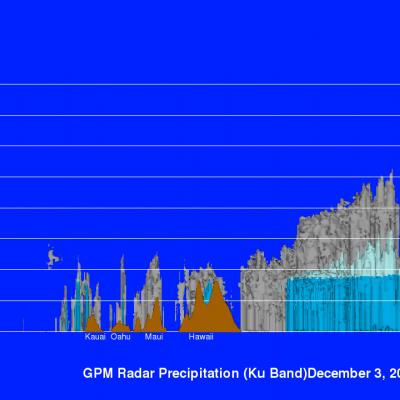
The mountains of Mauna Kea and Mauna Loa in the Hawaiian Islands have recently received heavy snowfall. Hawaii's balmy temperatures normally reach above 80 degrees Fahrenheit (27 C) at sea level on beaches such as Oahu's Waikiki but temperatures fall below freezing at the altitudes of tall mountain peaks on the Big Island. At 13,802 feet (4.2 km) Mauna Kea is Hawaii's tallest mountain. Snowfall is frequently seen on Mauna Kea's peak. The nature of precipitation in the Hawaiian Islands was recently examined using data collected by the GPM core observatory satellite. GPM flew over the Hawaiian